
By Amanda Castro
Associate News Editor
0
Share
Newsweek is a Trust Project member
See more of our trusted coverage when you search.Prefer Newsweek on Googleto see more of our trusted coverage when you search.
In the West, a series of storms is set to bring heavy snow and rain through the weekend. A storm already affecting California's Sierra Nevada mountains has dumped up to half a foot of snow, causing accidents and traffic backups on I-80. A new, stronger storm is expected to hit later Friday, bringing heavy rain and mountain snow from Washington to California. Winter Storm Warnings have been issued for the California mountains, where up to 4 feet of snow is possible. Northern California could also see up to 5 inches of rain, with a Flood Watch in effect for the region. The eastern half of the U.S. is facing an intense arctic blast, stretching from Minnesota to northern Florida and up to New England. The cold front brought lake-effect snow, dumping 3.5 feet of snow in western New York and up to 20 inches in northern Lower Michigan. Winds gusted to nearly 40 mph, creating dangerous whiteout conditions. A Lake-Effect Snow Warning remained in effect Friday morning for Ohio, Pennsylvania, and western New York, where an additional 6 to 12 inches of snow is possible. Wind chills early Friday were below zero in Minneapolis, near zero in Chicago, and in the teens in the Northeast. In the Southeast, temperatures were near freezing, with a Frost Advisory in place for northern Florida and southern Georgia. Meanwhile, a new storm system is moving into the Plains and Midwest, bringing freezing rain and icy conditions. Ice Storm Warnings have been issued for Iowa, while Icy Alerts stretch from Kansas to Minnesota. The icy conditions, expected to last through Saturday morning, could glaze roads, creating hazardous driving conditions. Des Moines, Minneapolis, and Omaha are among the cities under alerts, and travel is strongly discouraged.
This live blog is now closed.
Dec 13, 2024 at 04:16 PM EST
Hawaii faces expanding drought conditions
Hawaii has experienced drier-than-normal conditions, resulting in growing precipitation deficits and declining streamflow across the state, the National Weather Service has reported. Drought conditions have worsened, particularly on the Big Island and in the windward areas of Oahu, Molokai, and Maui.
These regions are seeing significant dryness, which has further contributed to the expansion of drought. As the situation intensifies, concerns over water availability and environmental impact continue to rise.
Dec 13, 2024 at 03:19 PM EST
Warmer air and clear skies expected through the weekend in Tuscon
After a cooler Friday, Tucson is set to experience clearer skies and warmer temperatures heading into the weekend. Highs for both Saturday and Sunday will be in the low to mid-70s, while overnight lows remain in the lower 40s due to the dry conditions.
Looking ahead, a series of low-pressure systems will move through the U.S. in the coming week, which could cause some uncertainty in temperature forecasts. However, no significant changes to the warm afternoons are expected at this time.
Rain chances will remain minimal, with no significant precipitation expected through the week of Christmas.
Dec 13, 2024 at 02:13 PM EST
Winter weather advisory issued for parts of Minnesota and South Dakota
The National Weather Service in Aberdeen has issued a Winter Weather Advisory, effective from 9 PM this evening to 10 AM CST Saturday. The advisory covers areas of west central Minnesota and northeast South Dakota, including Sisseton, Clark, Ortonville, Watertown, Milbank, Webster, Clear Lake, Hayti, Britton, and Wheaton.
Residents should expect a wintry mix of light freezing drizzle and snow, with ice accumulation expected to form a light glaze and snow amounts likely to be minimal. These conditions are expected to create hazardous driving conditions, particularly on untreated roads, bridges, and overpasses.
Motorists are urged to slow down and exercise caution. For up-to-date road conditions, Minnesota residents can visit 511mn.org or call 511, while South Dakota residents can check road conditions by calling 511.
Dec 13, 2024 at 12:58 PM EST
Sacramento, CA weather report: Above-average temperatures with showers and gusty winds expected
Sacramento is experiencing warmer-than-usual temperatures today, with a high of 51.5°F, which is 4.2°F above the 5-year historical average of 47.3°F. There is an 82% chance of precipitation, with showers expected to begin after 5 a.m. and continue through the morning. Patchy fog is also expected throughout the day, with temperatures reaching a high of 54°F before dropping to a low of 48°F.
A wind advisory is in effect for the Sacramento area, with winds from the southeast gusting up to 50 mph, potentially leading to power outages and hazardous conditions for travelers. The forecast for the next few days calls for continued showers on the 14th, with a high of 56°F, followed by partly cloudy skies and a low of 38°F. The weather will clear on the 15th with mostly sunny skies and a high of 52°F.
The temperature today marks a significant deviation from the historical average, and residents can expect a wet and windy few days ahead.
Dec 13, 2024 at 12:38 PM EST
Ice storm warning issued for central Iowa as freezing rain expected Friday night
Iowa is experiencing cold and quiet weather Friday morning, with temperatures in the single digits and wind chills near zero. While the day will remain mostly calm, an ice storm warning has been issued for central Iowa starting tonight.
Expect cloudy conditions throughout the day with temperatures slowly warming to the low 20s. The morning commute should be uneventful, though some sunshine may break through the clouds.
However, by early evening, light freezing drizzle and freezing rain are expected to move in, beginning in western Iowa around 5 p.m. and spreading eastward into the Des Moines metro by 7-9 p.m.
The freezing rain will likely intensify between 3 and 6 a.m. Saturday, leading to significant ice accumulation in areas from Ottumwa to Marshalltown, with up to a quarter-inch of ice expected. This could create hazardous travel conditions and potential power outages or minor tree damage.
Dec 13, 2024 at 12:14 PM EST
Wintry mix and freezing rain expected to impact Midwest Saturday
A potentially disruptive wintry mix, including freezing rain, is forecast for the Middle Missouri Valley and Upper Midwest on Saturday, The National Weather Service reported. An Ice Storm Warning has been issued for affected areas, with power outages and tree damage likely due to the ice buildup.
Travel could become nearly impossible, posing significant risks to motorists. Authorities are urging residents in these areas to plan ahead and take precautions to keep themselves and their families safe as the storm moves in.
Dec 13, 2024 at 12:00 PM EST
Christmas weather forecasts: What map says about travel conditions
...
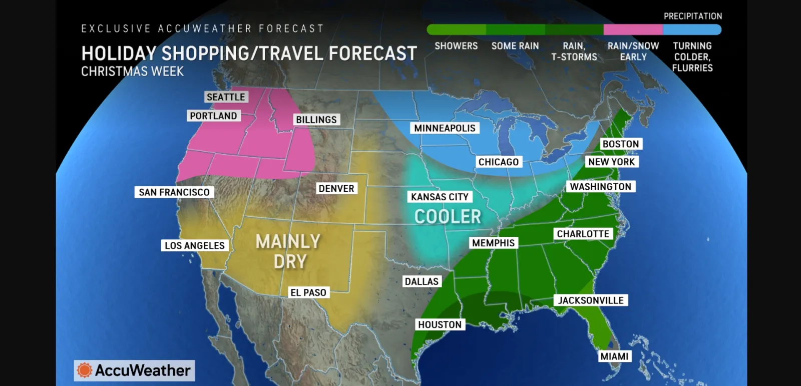
Early weather forecasts from AccuWeather imply that some holiday travelers and last-minute shoppers could have rain or snow to contend with during Christmas week.
The forecasts come after tumultuous Thanksgiving travel for many people in the Northeast, particularly those on their way home from family gatherings on Black Friday as heavy lake-effect snow hit Ohio, Pennsylvania and New York. The storm was strong enough to prompt some officials to urge people to delay travel home as snowplows would have a difficult time keeping roads clear during heavier bouts of snow.
With just under two weeks to go until Christmas, the forecasts could still change. However, as of this week, AccuWeather meteorologists are anticipating that rain, snow and winter storms could hit much of the United States during Christmas week.
A colder pattern will take hold in the Northeast and Midwest during Christmas week, AccuWeather reported, along with the chance of a winter storm.
According to a map included in the forecast, the chance at rain could extend from Maine through eastern Texas, with the greatest chance of thunderstorms possible in far eastern Texas, southern Louisiana, southern Alabama, southern Mississippi and the far western panhandle of Florida.
The Northwest could have rain and snow to contend with, the map showed, though the Southwest and much of the central U.S. are expecting "mainly dry" weather, AccuWeather reported.
Read the full story by Anna Skinner on Newsweek.
Dec 13, 2024 at 11:48 AM EST
Ohio Weather Update: Lake-effect snow winds down, milder temperatures ahead
Lake-effect snow in parts of Lake and Geauga counties will weaken by late to mid-morning, with snowfall reports from Thursday afternoon and evening marking the end of the heavier snow. The rest of Ohio will experience mostly sunny skies, with temperatures ranging from the mid-20s to around 30°F. Lingering flurries will continue in the snowbelt, but the afternoon will remain quiet.
Temperatures are expected to rebound this weekend, with milder conditions on the horizon. However, rain is set to develop by Sunday morning, spreading across the region. Looking ahead, Ohio will experience four weather systems next week, with light snow possible late next week into the weekend before Christmas.
As we approach the holiday season, a milder trend is expected around Christmas, followed by a return to colder conditions toward the end of the month and into early January. This shift in weather is expected to be gradual, as several global factors must align to bring prolonged cold temperatures.
Dec 13, 2024 at 11:36 AM EST
What classifies as a blizzard?
The National Weather Service (NWS) has shared information on what classifies as a blizzard, which are deadly winter storms that combine blowing snow and wind, resulting in extremely limited visibility. Blizzards are frequently accompanied by massive snowfalls and extreme cold. Strong winds can take up previously fallen snow, resulting in a ground blizzard.
The NWS defines a blizzard as a storm with huge volumes of snow OR blowing snow, winds greater than 35 mph, and visibility less than 1/4 mile for at least 3 hours. Blizzard conditions are often encountered on the northwest side of a severe storm system. The difference between the storm's lower pressure and the higher pressure to the west generates a tight pressure gradient, or pressure differential between the two sites, resulting in extremely powerful winds. These high winds take up available snow from the ground or blow any snow that falls, resulting in extremely limited visibility and the possibility of substantial snow drifting.
Dec 13, 2024 at 11:27 AM EST
Why early snowfall forecasts often miss the mark

...
The Weather Channel reports that each winter, there's a rush to predict snowfall, but early forecasts can often be highly inaccurate. While the excitement of knowing when and where snow will fall is understandable, patience is key, as snowfall details often can't be reliably predicted until one to three days before the storm.
Snowfall maps shared on social media, often featuring colorful contours in blue, pink, and purple, are frequently based on computer models that can change drastically from one run to the next. While meteorologists might spot early signs of a storm five to seven days in advance, specific details, such as exact snow amounts, are hard to pin down. This is due to the uncertainty of weather disturbances that could be thousands of miles away and the lack of detailed data from those regions.
Instead of rushing to conclusions, forecasters typically issue broad warnings within a general timeframe, advising that more specific details will follow as the storm's development becomes clearer. It's important to avoid spreading unverified snowfall forecasts, as early predictions often change and can create unnecessary confusion.
Dec 13, 2024 at 11:17 AM EST
Areas with the best chance of snow this holiday
AccuWeather has revealed the cities across the U.S. with the highest chances of getting hit with a "white Christmas" this year.
"It's been a cold start to December for much of the eastern half of the nation. Don't expect the cold to stick around too much longer. We expect a pattern shift in mid-December with a change from a cold Polar air mass to a milder Pacific air mass, especially for the central and eastern United States," AccuWeather Lead Long-Range Expert Paul Pastelok said. "This can lead to snow melt for many areas that received snow at the start of the winter season, not leaving too much snow around just before Christmas."
On the list are:
- Denver, Colorado
- Chicago, Illinois
- Indianapolis, Indiana
- Boston, Massachussetts
- Columbus, Ohio
- New York City, New York
Dec 13, 2024 at 10:55 AM EST
Washington, DC Weather Report: Cooler-than-average temperatures with a dry forecast
Washington, DC, is experiencing cooler-than-average temperatures on December 13, 2024, with a high of 41°F, which is 7.9°F below the 5-year historical average of 42.4°F. The low tonight is expected to drop to around 29°F, indicating a chilly evening. The 1% chance of precipitation suggests dry conditions throughout the day.
Looking ahead, the weather will remain mostly sunny over the next few days, with highs near 39°F on December 14th and 43°F on December 15th. While precipitation is unlikely on December 13th and 14th, the chance of rain increases on December 15th, especially after 1 p.m., as temperatures remain below average. With a significant temperature deviation and a dry start, the weather in DC will remain cool but stable for the next few days.
Dec 13, 2024 at 10:42 AM EST
Satellite imagery reveals lake-effect snowstorm sweeping the Great Lakes
Stunning satellite imagery has captured the ongoing lake-effect snowstorm blanketing the Great Lakes region. The National Weather Service (NWS) shared these visuals, which were taken by the Geostationary Operational Environmental Satellites (GOES), on X (formerly Twitter).
"Impressive @NOAASatellites loop of lake-effect snow bands across the Great Lakes," the NWS wrote. "The heavy snow forms when cold air from the interior of Canada moves over the relatively warmer lakes. Numerous counties in Michigan and New York remain under warnings due to this snow."
Dec 13, 2024 at 10:35 AM EST
Short days, snowy conditions, and wind in Adirondack High Peaks
The Adirondack High Peaks region has been experiencing strong winds, so hikers and travelers should be prepared for blowdowns along trails. Additionally, blowing and drifting lake-effect snow has been affecting the Western and Northern Adirondacks, and is expected to move south.
More widespread snow is also forecast for early next week, bringing additional winter conditions to the area.
Dec 13, 2024 at 10:26 AM EST
Gainesville, FL Weather Report: Cooler-than-average temperatures and sunny conditions
Gainesville, Florida is experiencing cooler-than-usual temperatures on December 13, with the current temperature at 54°F, 3.9°F below the 5-year historical average of 57.9°F. Despite the cooler start, today's weather is mostly sunny, with a high near 70°F and a low around 54°F. The chance of precipitation is minimal, with only a 6% probability in the next 24 hours.
Looking ahead, the forecast calls for mostly sunny conditions with temperatures gradually warming. On December 14th, expect a high near 75°F and a low around 59°F, followed by another sunny day on the 15th with a high near 76°F and a low around 57°F.
Historically, Gainesville sees very little precipitation on December 13th, with an average of just 0.01 inches over the past five years. The dry and stable conditions are expected to continue, making for pleasant weather over the next few days.
Dec 13, 2024 at 10:18 AM EST
Polar vortex may change America’s ‘winter’

...
A late-season polar vortex could extend America's winter-like temperatures into early spring, according to AccuWeather.
So far in December, temperatures across the nation have trended above average. The National Weather Service (NWS) Climate Prediction Center expects above-average temperatures to affect more than half the U.S. over the next two weeks, according to its most recent temperature outlooks. Alaska has been among the states with the strongest above-average temperatures.
However, the warmer temperatures aren't likely to stick around for the entire winter. The seasonal outlook from the NWS Climate Prediction Center shows below-normal temperatures across the Northern and Northwestern U.S., and AccuWeather meteorologists anticipate a possible polar vortex to descend into the U.S. in February.
Read the full story by Anna Skinner on Newsweek.
Dec 13, 2024 at 10:06 AM EST
Winter weather advisory issued for Chippewa County

...
The National Weather Service issued a winter weather advisory for Chippewa County, Wisconsin on Friday, in effect from 9:41 a.m. EST until 4 p.m. EST. The advisory warns of snow, with total daytime accumulations of up to 4 inches, particularly over northern Sugar Island.
The weather service advises travelers to expect slippery road conditions and urges motorists to slow down and exercise caution while traveling.
Dec 13, 2024 at 10:01 AM EST
How dry period impacted California’s biggest reservoir’s water levels
Water level increases at Lake Shasta have leveled off this month after a dry start to December for northern California.
Multiple atmospheric rivers hit California in late November. During that time, the water level at Lake Shasta, California's biggest reservoir, rose by 12 feet. The state's second-largest reservoir, Lake Oroville, also saw water level increases during the same period. A California Department of Water Resources (DWR) spokesperson attributed the lake's performance to atmospheric rivers.
However, the lakes have both leveled off during the first two weeks of November. NWS lead meteorologist Eric Kurth told Newsweek that no significant or long-duration storms have hit northern California during the weeks-long dry break.
On Thursday afternoon, Lake Shasta was at 998 feet elevation, just shy of 69 feet below full capacity. Lake Oroville was at 784 feet in elevation, 115 feet below capacity.
Before the atmospheric rivers in November, water levels at both lakes had undergone a months-long decline. Both lakes are lower than they were during this time last year, although significantly higher than in December 2022.
During 2022, both reservoirs reached very low levels after battling years of drought, though much of California has since recovered.
Water levels could rise again this month as multiple storms take aim at California.
Read the full story by Anna Skinner on Newsweek.
Dec 13, 2024 at 09:41 AM EST
Winter weather advisory issued for parts of Kansas and Missouri
A winter weather advisory has been issued for northeast Kansas and northwest Missouri due to the potential for freezing drizzle. The advisory, which starts at 2 p.m. and runs until 9 p.m. for Atchison and Doniphan counties in Kansas and Buchanan County in Missouri, extends until midnight for counties further north.
The National Weather Service warns of slippery sidewalks, roads, and bridges, which could impact the Friday evening commute. Drivers are advised to slow down and exercise caution, especially those traveling to Nebraska or Iowa. While ice accumulation is expected to be minimal, even small amounts can cause hazardous conditions.
The freezing precipitation is expected to transition to rain and drizzle early Saturday.
Dec 13, 2024 at 09:31 AM EST
Kansas City braces for potential freezing drizzle ahead of Friday rain
Kansas City is closely watching its temperatures to determine whether rain will arrive as freezing drizzle or plain rain on Friday. The morning started with frigid temperatures, dipping to 17 degrees at Kansas City International Airport, with wind chills making it feel as cold as 4 degrees.
The National Weather Service forecasts rain to spread from south to north across the region in the afternoon and evening. However, parts of northeastern Kansas and northern Missouri will still be below freezing when the rain arrives. Freezing drizzle is possible in those areas, especially north of U.S. Highway 36 in northern Missouri. While the chance of freezing drizzle affecting the northern side of the Kansas City metro is under 10%, it remains a possibility.
Temperatures are expected to rise to 42 degrees by the afternoon, bringing the city to near-average levels for this time of year.
Dec 13, 2024 at 09:20 AM EST
National Weather Service shares wintry images from Michigan
The National Weather Service in Gaylord, Michigan has shared images of a wintry sunrise in the area.
Dec 13, 2024 at 09:06 AM EST
Winter weather warnings in 11 states as 3 feet of snow to hit
Millions of Americans can expect a barrage of snow today and Saturday, the National Weather Service (NWS) has said.
A slew of warnings and advisories have been issued across 10 states, primarily concentrated in the Midwest region, with the Western states of California and Washington also expecting snowy conditions. Two snowstorms coming in from the Pacific Ocean are forecast to hit Western states on Friday, while chilly conditions in the Midwest will bring snow and ice throughout today and into the weekend.
Read the full story by Aliss Higham on Newsweek.
Dec 13, 2024 at 08:50 AM EST
Staying safe on winter roads: Tips for navigating hazardous weather conditions

...
Traveling in winter conditions requires vigilance, as weather-related crashes are a significant risk. According to the Department of Transportation, 24% of vehicle crashes each year are caused by snowy, slushy, or icy pavements, and 15% happen during snowfall or sleet. These accidents result in over 1,300 fatalities and 116,800 injuries annually. Fast-changing weather, such as snow squalls, can also lead to severe crashes. Last year, whiteout conditions caused by rapid snow squalls resulted in more than 140 accidents and 3 fatalities in states like Indiana, Pennsylvania, and New Hampshire, Weather.gov reported.
To stay safe, travelers should take several precautions. First, check local weather forecasts from the National Weather Service (NWS) to stay updated on rapidly changing conditions. Road conditions can vary, so it's important to monitor alerts and advisories for your route. Utilize mobile weather apps, such as mobile.weather.gov, to keep track of real-time updates.
Additionally, winterizing your vehicle can prevent problems in harsh conditions. The National Highway Traffic Safety Administration offers a checklist for ensuring your car is prepared. Finally, packing a winter weather emergency kit, with essential items like blankets, a flashlight, and extra food, can help you stay prepared for unexpected situations. Being proactive and informed is key to staying safe on winter roads.
Dec 13, 2024 at 08:39 AM EST
Travel ‘strongly discouraged’ during ice storm warning
Hundreds of thousands of people across Iowa are braced for extremely icy weather as temperatures plummet.
An "Ice Storm Warning" has been issued by the National Weather Service (NWS) for 12 counties across Iowa, with residents being warned not to travel due to "significant icing."
This warning affects Benton, Black Hawk, Buchanan, Cedar, Grundy, Iowa, Jasper, Johnson, Linn, Marshall, Poweshiek, and Tama counties.
The warning comes into effect this evening, and will last into Saturday afternoon. The NWS Quad Cities office notes that this is the first Ice Storm Warning they have issued in 658 days.
Read the full story by Jess Thomson on Newsweek.
Dec 13, 2024 at 08:32 AM EST
Winter storms bring heavy snow, rain, and hazardous conditions to the West Coast
A series of storms in the West is expected to bring heavy snow and rain through the weekend. One storm has already dumped up to half a foot of snow in California's Sierra Nevada mountains, causing accidents and traffic delays on I-80. A stronger storm is set to arrive Friday, bringing heavy rain and mountain snow from Washington to California.
Winter Storm Warnings are in effect for the California mountains, where up to 4 feet of snow is possible, while northern California could see up to 5 inches of rain, triggering a Flood Watch for the area.
Dec 13, 2024 at 08:23 AM EST
Atmospheric river set to ‘wallop’ western US: What we know
A pair of storms and accompanying atmospheric river are set to deliver heavy rain, mountain snow and strong winds to the Western United States from Friday into Saturday.
This weather system, described by meteorologists as a "river in the sky," will bring significant impacts to California, Oregon and Washington.
The National Weather Service (NWS) and AccuWeather have issued warnings for potential flooding, power outages and hazardous travel conditions as the storms "wallop" the coast.
Atmospheric rivers are narrow bands of concentrated water vapor that carry immense amounts of moisture from tropical regions to higher latitudes. According to the NWS, these systems can transport as much as 15 times the water vapor as the Mississippi River carries in liquid form.
Read the full story by Tom Howarth on Newsweek.
View 0 Comments
Submit Correction
View Editorial & AI Guidelines