
...

By Anna Skinner
Associate News Editor
0
Share
Newsweek is a Trust Project member
See more of our trusted coverage when you search.Prefer Newsweek on Googleto see more of our trusted coverage when you search.
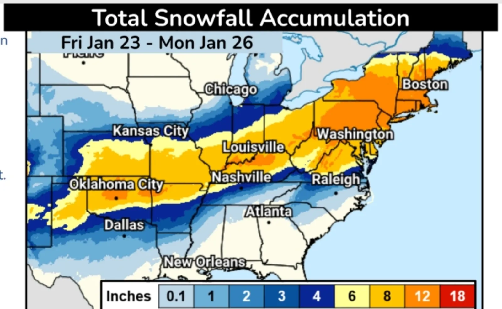
A new winter storm map from the National Weather Service (NWS) Weather Prediction Center reveals how much snowfall states are expecting as Winter Storm Fern begins to unleash its impacts on Friday night.
The latest key messages from the Weather Prediction Center were issued on Friday afternoon, just hours after winter storm warnings went into effect in the Southern Plains states. The storm is set to hit Texas and Oklahoma first, then creep eastward across the Gulf Coast and the South, and then up into the Mid-Atlantic and Northeast by the end of the weekend. It will be a long-lasting storm with widespread impacts; snowfall is expected from Michigan south through central Louisiana, with ice expected along the southern track of the storm.
According to the most recent map from the NWS, the heaviest snowfall is expected in central Oklahoma, northwestern Arkansas, southern Indiana, northern Kentucky, southeastern Ohio, Pennsylvania, New Jersey, Massachusetts, New York, Connecticut, Rhode Island, Vermont, New Hampshire, and southern Maine, as well as parts of Virginia and West Virginia. These states are expecting up to 12 inches of snow.
Read More on U.S.
A much more widespread swath of 8 inches of snow is expected to fall from northern Texas up through Maine.
...
"A significant winter storm is expected to threaten nearly 180 million Americans with widespread heavy snow, sleet, and freezing rain from the Southern Rockies to New England through Monday," the key message said. "Extremely cold air will follow, prolonging dangerous travel and infrastructure impacts into next week."
School Closures, Mail Delivery Affected
The storm has already prompted dozens of schools to close on Friday, with more planning to close on Monday as long-lasting impacts are likely.
Meanwhile, the U.S. Postal Service said mail delivery across the eastern half of the U.S. could be delayed because of the storm. Airports are also likely to endure delays and cancellations until after the storm passes.
People were advised to make preparations to prevent pipes from freezing and to prepare to have clean water on hand in case of long-term power outages, such as filling their bathtubs with water ahead of the storm.
Ice Storm Warnings Issued for Millions
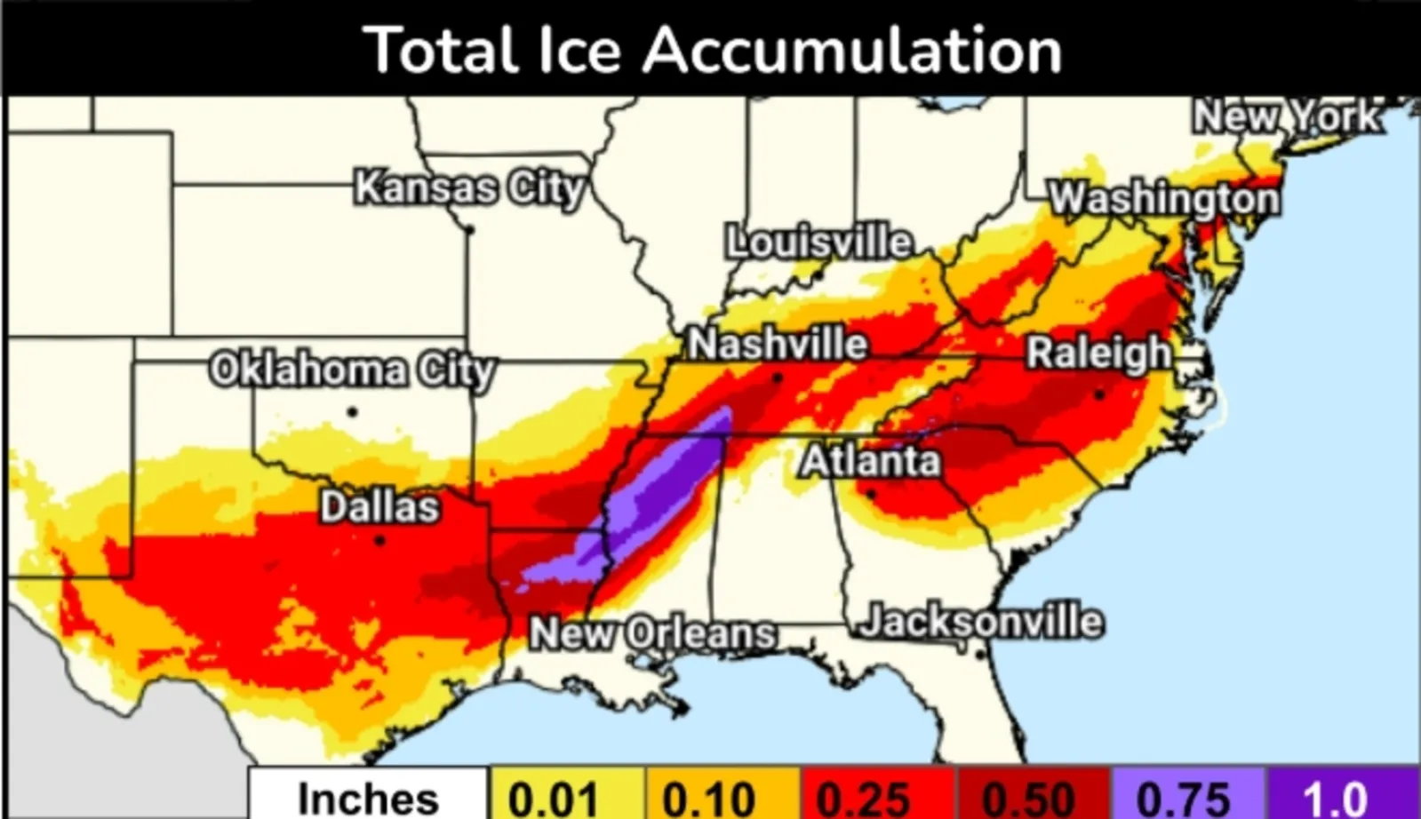
Further south, ice accumulation will be of most concern. Up to an inch of ice is expected to accumulate from northeastern Louisiana through Mississippi and into southwestern Tennessee. More widespread amounts of half an inch to three-quarters of an inch will be from Texas up through Virginia.
The Weather Prediction Center warned that "catastrophic" impacts would occur for any areas that saw over a half-inch of ice accumulation.
At this amount, ice can snap tree branches and power lines, leading to widespread power outages that could last days. As long as temperatures remain below freezing, AccuWeather senior meteorologist Tom Kines told Newsweek, power outages could last for days, as power companies can't remedy the issue until the ice melts.
In Alabama, the incoming storm prompted the NWS office in Huntsville to issue its first ice storm warning in five years, a spokesperson from the office told Newsweek.
...
Extreme Cold Warnings
NWS meteorologists have issued extreme cold warnings across the Northern Plains, Upper Midwest, Northeast, and as far south as Texas.
"Dangerously cold wind chills as low as 5 degrees could result in hypothermia or frostbite on exposed skin if precautions are not taken. Extreme cold will become life threatening and likely damage unprotected pipes and put livestock at risk," an extreme cold warning issued by the NWS office in Austin, Texas, said.
People in affected areas are urged to prepare if there's still time before the storm arrives. Meteorologists encouraged people to "dress in layers including a hat, face mask, and gloves if you must go outside," keep pets indoors, ensure outdoor animals have warm, dry shelter, food and unfrozen water; and check up on neighbors and family. During heavy snowfall or when roads are icy, people are urged to delay all travel.
View 0 Comments
Submit Correction
View Editorial & AI Guidelines