
...

By Anna Skinner
Associate News Editor
0
Share
Newsweek is a Trust Project member
See more of our trusted coverage when you search.Prefer Newsweek on Googleto see more of our trusted coverage when you search.
Winter storm maps are highlighting a turbulent week ahead as a powerful system already hammering the U.S. West begins its push eastward, with heavy snow, strong winds and hazardous travel expected to expand into the Great Lakes and Northeast by mid‑ to late week.
A winter storm currently walloping the western U.S. has prompted numerous "life-threatening" weather alerts across the region. Forecasters say the same Pacific‑driven energy producing heavy Sierra Nevada snowfall and renewed rainfall along the West Coast will help fuel the cross‑country system. The storm is forecast to develop in the Northern Rockies before sweeping across the Northern Plains and into the Great Lakes, where accumulating snow is expected to spread into upstate New York and northern New England. During this same timeframe, severe thunderstorms will affect parts of the Midwest and U.S. South.
"If this pans out the way we are concerned for severe weather on Thursday, it could be a nasty spring snap back in an area that was adversely affected by snow and ice in recent weeks," AccuWeather Chief Meteorologist Jonathan Porter told Newsweek in an email.
Read More on Weather
...
New forecast maps from AccuWeather show the extent of the winter storms across the U.S. this week.
Winter Storm Impacts on Tuesday
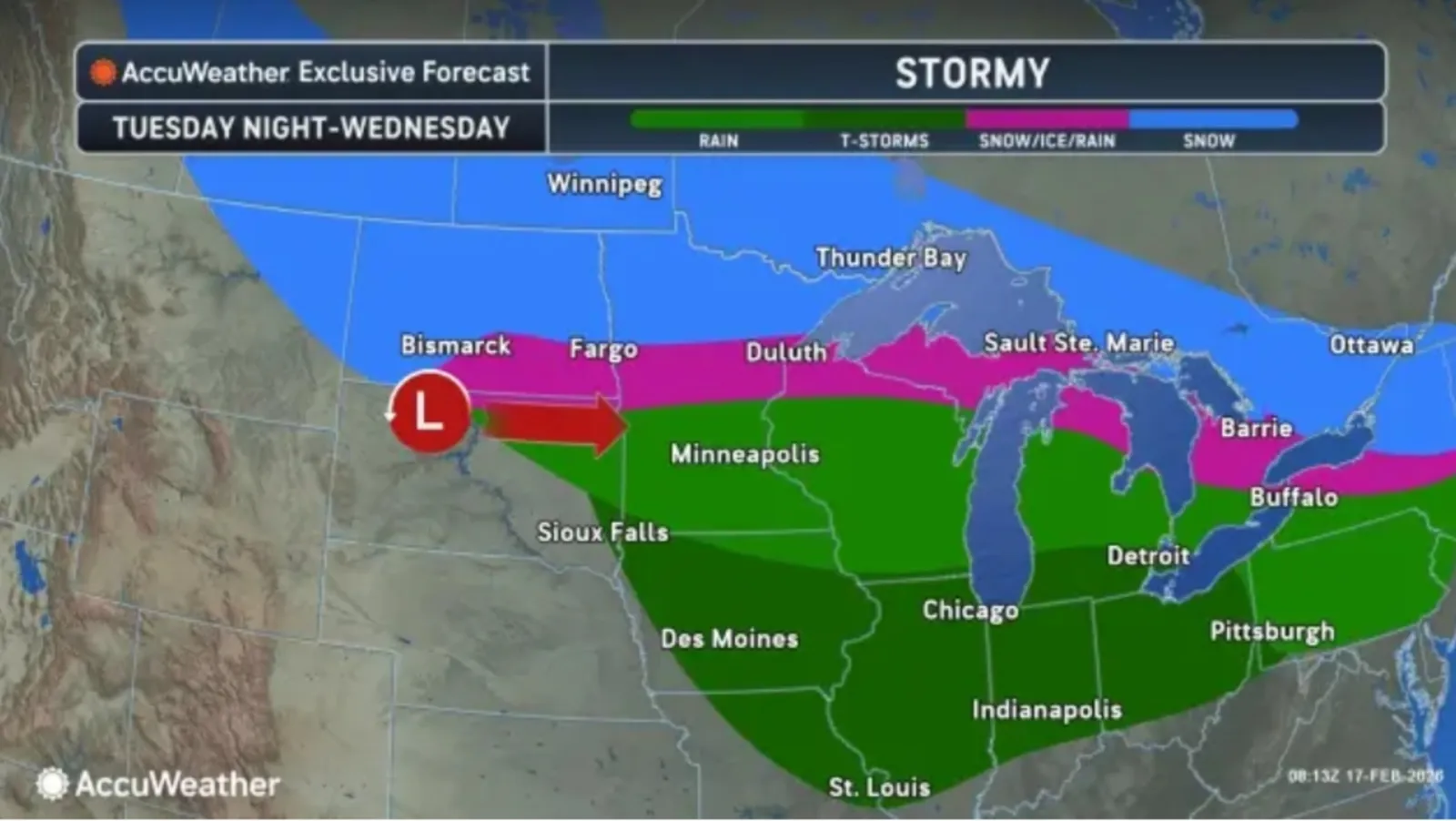
By Tuesday night, impacts from the storm will stretch into the Upper Midwest and Great Lakes regions. Much of this area is expecting rain, according to an AccuWeather map, but a narrow band through southern North Dakota, central Minnesota, northern Wisconsin, northern Michigan and central New York could see snow and ice mixed in. Snow is expected north of this band.
...
Winter Storm Impacts on Wednesday
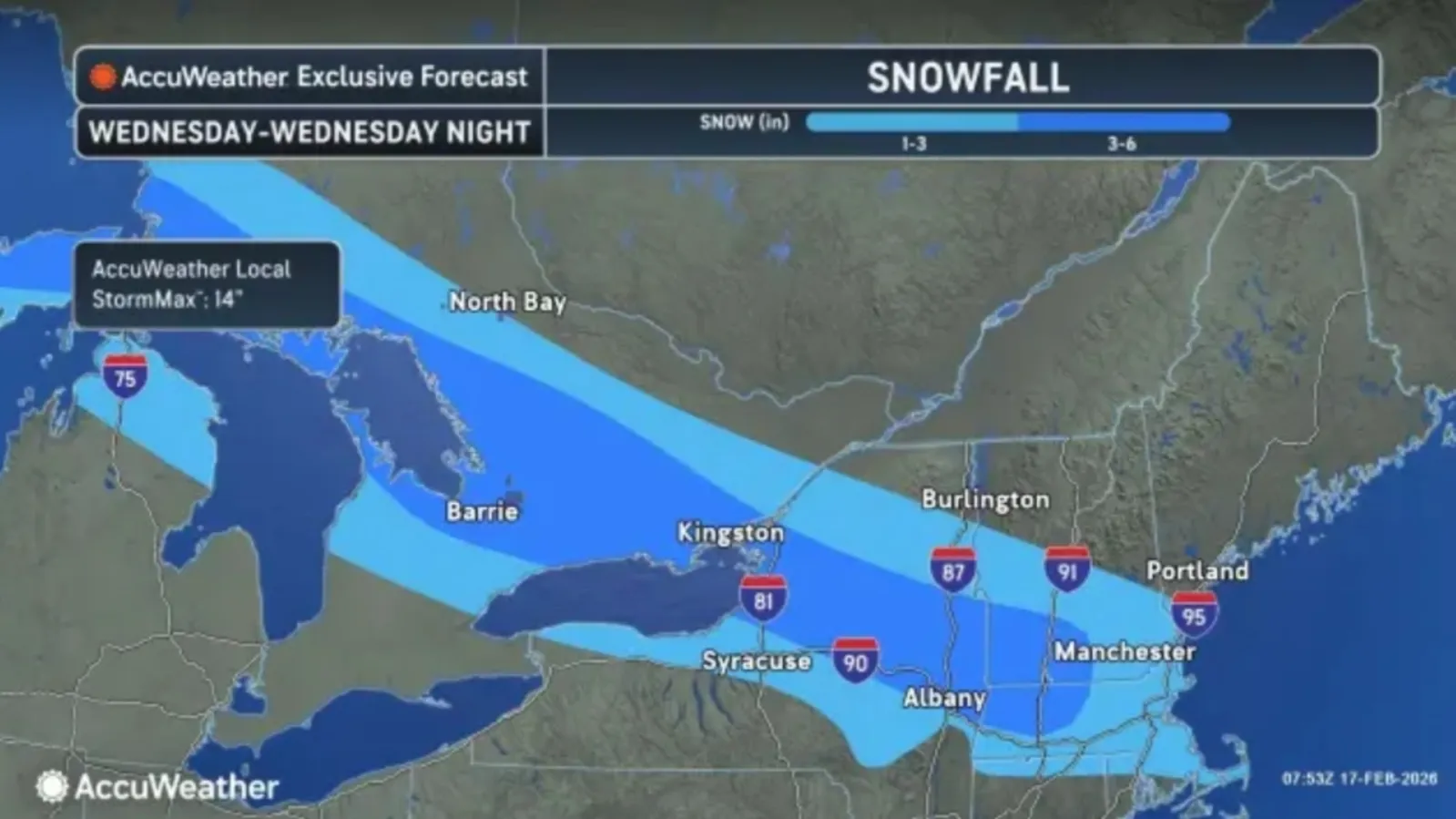
By Wednesday, more widespread snowfall will hit the Northeastern U.S. Much of New York, Vermont, southern New Hampshire, Massachusetts, northern Connecticut, and Rhode Island will see amounts between 1 and 3 inches, but central New York, southern Vermont, southwestern New Hampshire, and northwestern Massachusetts will see amounts up to 6 inches, according to the forecast.
...
Winter Storm Impacts Later This Week
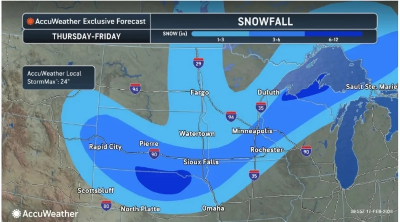
After the first storm has exited the region, a second storm will bring more winter impacts to parts of the Midwest and Plains on Thursday and Friday, the AccuWeather forecast said.
"A wide strip of 3-6 inches of snow can accumulate from South Dakota and Nebraska to the Upper Peninsula of Michigan," the forecast said. "Pockets of 6-12 inches of snow, with the AccuWeather Local StormMax™ of 24 inches, could occur in northern Nebraska and off of Lake Superior in Michigan."
...
The National Weather Service (NWS) has also started issuing forecasts regarding the incoming impacts to the Plains, Midwest, and Northeast.
"Over the Plains into the Midwest, frontal boundaries and moisture return will support chances for rain and snow Tuesday evening. On Wednesday, the low pressure system will accumulate higher amounts of mixed precipitation over the Upper Midwest/Great Lakes as it continues to move eastward into Mississippi/Ohio Valley," a Tuesday forecast said. "The surface low will slowly move into the Northeast by Wednesday into Thursday with a elongated trough that extends into the Mid-Atlantic. This will bringing chances for rain and high-elevation snow across the Mid-Atlantic and Northeast through Thursday."
As of Tuesday morning, there are no winter storm warnings or watches in place across the Northeast, although some warnings are in effect in the Northern Plains. People living in the impacted region are encouraged to monitor local weather forecasts and be prepared once the winter storm arrives.
View 0 Comments
Submit Correction
View Editorial & AI Guidelines