NWS Weather Prediction Center

By Anna Skinner
Associate News Editor
0
Share
Newsweek is a Trust Project member
See more of our trusted coverage when you search.Prefer Newsweek on Googleto see more of our trusted coverage when you search.
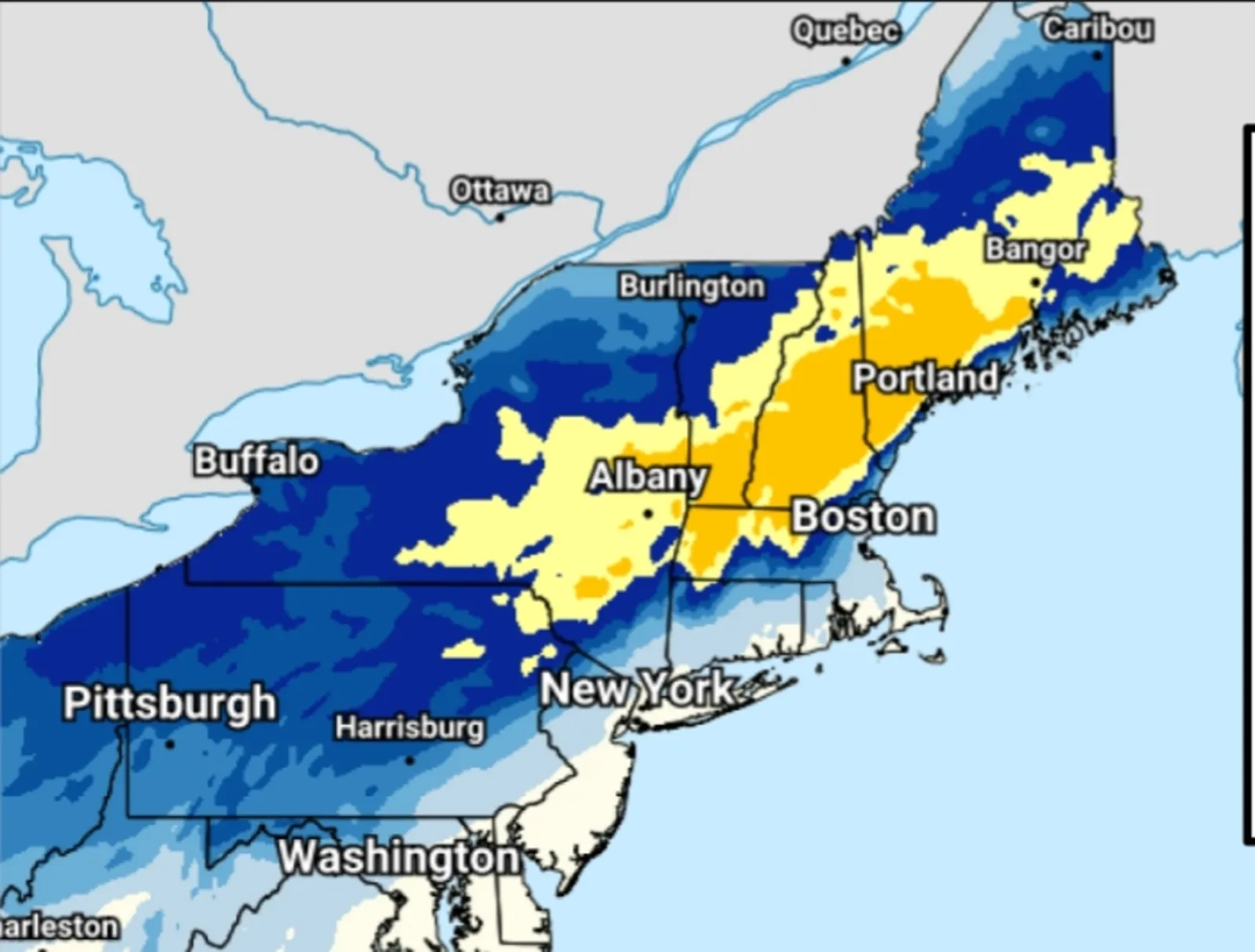
A map shared by the National Weather Service (NWS) Weather Prediction Center shows which parts of the Northeast and Mid-Atlantic will see the heaviest snowfall on Tuesday as a winter storm continues to rage.
The updated snowfall totals come as hundreds of schools closed across the region on Tuesday. Most winter storm warnings and winter weather advisories issued for the region will remain in place through the early mornings hours on Wednesday, with as much as 12 inches of snow falling in New England through Wednesday morning.
The heavy snow is currently on track with forecasts, NWS meteorologist Jon Palmer told Newsweek, though the worst is yet to come, with most of the snow to fall this afternoon.
Read More on U.S.
According to the new snowfall total map, the hardest hit areas will be northern and western Massachusetts, southern Vermont, most of New Hampshire and southeastern Maine, where between 8 and 12 inches of snow will be possible. Slightly lesser amounts, between 6 and 8 inches are more widespread, stretching into much of New York, far northern Connecticut and northeastern Pennsylvania.
...
However, several inches of snow will be possible for the entire region from Ohio east through Maryland and up through the furthest north parts of Maine.
"Heavy snow (5-10" expected) in the Interior Northeast & disruptive ice (up to 0.2" accretion) in the Central Appalachians will make today's commutes HAZARDOUS. The storm exits by Wednesday morning," NWS Weather Prediction Center posted with the map on Facebook on Tuesday.
There is a high chance that snowfall rates will exceed 1 inch per hour, making it difficult to keep roads clear as the snow continues to fall heavily. Further south, the southern and central Appalachians will face the threat of freezing rain, which will make for hazardous travel.
"Travelers should anticipate extensive disruptions," the post added.
The Tuesday evening commute will likely be affected.
Many NWS offices in the region warned people against traveling unless absolutely necessary.
"Travel could be very difficult. The hazardous conditions will impact the evening commute," NWS Boston said in a winter storm warning.
Other NWS offices urged motorists to keep a survival kit in their car that included blankets, a flashlight, food and water in case they became stranded.
"Persons should delay all travel if possible. If travel is absolutely necessary, drive with extreme caution and be prepared for sudden changes in visibility," NWS Gray, Maine, said in a winter storm warning, adding: "Leave plenty of room between you and the motorist ahead of you, and allow extra time to reach your destination. Avoid sudden braking or acceleration, and be especially cautious on hills or when making turns. Make sure your car is winterized and in good working order."
Most winter storm alerts will expire for the region by Wednesday morning, but below-average temperatures will likely persist.
Meanwhile, light snow is expected to accumulate in Texas and Oklahoma overnight Wednesday into Thursday morning, with NWS meteorologists still considering whether or not they will issue official alerts for the winter weather.
View 0 Comments
Submit Correction
View Editorial & AI Guidelines