

By Amanda Castro and Hannah Parry
0
Share
Newsweek is a Trust Project member
See more of our trusted coverage when you search.Prefer Newsweek on Googleto see more of our trusted coverage when you search.
Oregon's Cram Fire has rapidly grown to engulf nearly 30,000 acres, prompting evacuations across multiple counties on Tuesday.
The wildfire was first reported as a small bush fire on Sunday along U.S. Route 97 near Willowdale in Jefferson County. By Monday, the fire had expanded to cover 4,500 acres, prompting evacuations in Jefferson and Waco counties.
On Tuesday, the blaze exploded to over 28,000 acres as high temperatures, low humidity and strong winds created the ideal conditions for fires to spread.
What To Know
- The whole east side of Jefferson County is under a level three evacuation, meaning residents should leave immediately.
- Much of Hay Creek is under a level two warning, meaning residents must be prepared to leave at a moment's notice.
- The fire is at 0 percent containment.
- Multiple wildfires are also burning across western Colorado, prompting evacuations, road closures, and a statewide disaster declaration.
- Governor Jared Polis activated emergency response plans Sunday as crews battled five major blazes, all sparked by lightning strikes last week.
Newsweek's live blog is closed.
Jul 15, 2025 at 07:03 PM EDT
Arizona wildfires by the numbers
The wildfires in Arizona have burned through nearly 55,755 acres according to figures from the National Interagency Fire Center.
Billy Fire
- 752 acres
- 0 percent contained
- Located near Young
Dragon Bravo
- 5,717 acres
- 0 percent contained
- Located near North Rim
White Sage
- 49,286 acres
- 0 percent contained
- Located near Fredonia
Jul 15, 2025 at 06:52 PM EDT
Oregon wildfires by the numbers
The wildfires in Oregon have burned through nearly 25,554 acres according to figures from the National Interagency Fire Center.
Coyote Fire
- 395 acres
- 80 percent contained
- Located near Jordan Valley
Cram Fire
- 20,000 acres
- 0 percent contained
- Located near Madras
Elk Fire
- 2,699 acres
- 31 percent contained
- Located near Beatty
Grizzly Complex Fire
- 952 acres
- 47 percent contained
- Located near Medford
Highland Fire
- 719 acres
- 30 percent contained
- Located near Prineville
Long Point Fire
- 349 acres
- 86 percent contained
- Located near Spray
Jul 15, 2025 at 06:45 PM EDT
Colorado wildfires by the numbers
The wildfires in Colorado have burned through nearly 8,000 acres according to figures from the National Interagency Fire Center.
South Rim Fire
- 3,988 acres
- 0 percent contained
- Located near Montrose
Sowbelly Fire
- 2,274 acres
- 0 percent contained
- Located near Delta
Turner Gulch
- 1,495 acres
- 0 percent contained
- Located near Gateway
Jul 15, 2025 at 06:37 PM EDT
Multiple counties, cities report unhealthy air conditions as Cram Fire smokes driven southwest
Jefferson and Deschutes counties in Oregon have reported unhealthy air quality as smoke from Cram Fire is driven south westerly.
The city of Bend has reported an air quality of more than 200 particles, putting the air at "very unhealthy."
Residents who do not need to evacuated are urged to stay home.
Jul 15, 2025 at 06:29 PM EDT
Oregeon’s Highway 97 reopens with delays
Oregon's Highway 97 has reopened with delays amid multiple wildfires.
The highway was closed near Willowdale as Cram Fire moved westwards this morning, growing to engulf almost 30,000 acres.
The eastern half of Jefferson remains under level 3 evacuation orders, meaning residents were told to "go now."
The cause of the fire remains under investigation.
Jul 15, 2025 at 05:44 PM EDT
Map shows Cram Fire evacuation zones as blaze spreads to nearly 30,0000 acres
Jul 15, 2025 at 05:27 PM EDT
Nearly 500 firefighters are tackling the multiple wildfires in Colorado
Nearly 500 firefighters are tackling the multiple Colorado wildfires spreading across the state.
Teams of local, state and federal agencies are focusing on three large uncontained fires including Turner Gulch, Wright Draw and Sow Belly.
Both the Turner Gulch and Wright Draw blazes, which began after lighting strikes, are located in steep terrain which make them hard to reach by fire crews.
Jul 15, 2025 at 05:00 PM EDT
Evacuation order issued for areas near Colorado wildfires
Colorado's Mesa County Sheriff's Office has issued evacuation orders for an area near the Deer Creek Fire.
"Evacuations Ordered for All Areas of Highway 141 Between Mile Markers 131-134," the office said in a post on Facebook.
Residents are urged to go to their closest evacuation center, which would be at the Clifton Community Campus in Clifton.
"Please note, this is not an overnight shelter. Evacuees will be assessed for needs and provided resources, such as housing, by resource navigators at this location," the sheriff's office said, adding that anyone who needs help in securing shelter for their large animals should call 970-778-0161.
Jul 15, 2025 at 04:48 PM EDT
Air quality health advisory issued for wildfire smoke
An air quality health advisory has been issued for wildfire smoke in Colorado.
The Colorado Department of Public Health and Environment warning will remain in place until 9 a.m. MDT Wednesday.
"The heaviest smoke impacts will likely be in close proximity to the South Rim fire in eastern Montrose County, the Sowbelly Fire and Turner Gulch fires in southern Mesa County, and areas directly downwind of the Deer Creek fire in Montrose and San Miguel Counties," the health department said.
Affected areas include: Mesa, Delta, San Juan, Montrose, San Miguel, Ouray, Gunnison and Hinsdale Counties. Locations include, but are not limited to Grand Junction, Delta, Silverton, Montrose, Nucla, Telluride, Ouray, Gunnison and Lake City.
"If smoke is thick or becomes thick in your neighborhood you may want to remain indoors," the health department advised.
"This is especially true for those with heart disease, respiratory illnesses, the very young, and older adults. Consider limiting outdoor activity when moderate to heavy smoke is present. Consider relocating temporarily if smoke is present indoors and is making you ill. If visibility is less than 5 miles in smoke in your neighborhood, smoke has reached levels that are unhealthy."
Jul 15, 2025 at 04:33 PM EDT
Map shows where air quality has dipped amid wildfires

...
Jul 15, 2025 at 04:24 PM EDT
TABLE: Current Oregon wildfires than began this month
Jul 15, 2025 at 03:52 PM EDT
Canadian wildfire smoke triggers air quality alerts across North America
Smoke from hundreds of wildfires in Western Canada has drifted eastward, prompting hazardous air quality alerts in major cities like Toronto, Montreal, and Quebec City, as well as across the upper Midwest in the United States. Environment Canada issued warnings after haze settled over Toronto on Monday, with conditions improving slightly by Tuesday but remaining a concern due to lingering heat and smoke.
The fires, many sparked by lightning, have made Manitoba's 2025 wildfire season its worst in three decades. Premier Wab Kinew declared a second state of emergency last week, following deadly blazes that killed two and displaced over 30,000 residents.
In the U.S., states including Minnesota, Wisconsin, Illinois, and Michigan reported deteriorating air quality. Six Republican lawmakers blamed Canada's forest management practices for the smoke, escalating cross-border tensions already strained by trade disputes.
Meteorologists warn that smoke mixing down to surface levels poses significant health risks, particularly during prolonged heat waves. Officials continue to urge residents to limit outdoor activity and monitor air quality updates.
Jul 15, 2025 at 03:37 PM EDT
Wildfire smoke from Canada begins to impact Washington air quality
Wildfire smoke from British Columbia is drifting into Washington, prompting concerns about deteriorating air quality as temperatures rise across the state. The Placer Creek Fire is sending smoke into the Okanogan Valley, with visible haze reported near Aeneas Mountain west of Tonasket.
Active fires within Washington—including the Western Pines Fire in the east and the Hope Fire in the northeast—are also contributing to smoke levels. The Hope Fire has burned over 7,000 acres and triggered Level 3 evacuation orders.
While air quality remains in the "good" range statewide as of Tuesday, officials warn that northeasterly winds could push Canadian smoke into populated areas. By Wednesday, counties such as eastern Whatcom, eastern Skagit, and northern Snohomish may experience "moderate" air quality levels.
Jul 15, 2025 at 03:18 PM EDT
CAL FIRE launches burn severity viewer to track wildfire impact
CAL FIRE's Fire and Resource Assessment Program has unveiled the California Vegetation Burn Severity Online Viewer, a new public mapping tool designed to display the impact of wildfires on vegetation across the state, per a press release. The interactive platform supports transparency and resilience efforts outlined in Senate Bill 1101.
The viewer includes burn severity data for all wildfires exceeding 1,000 acres from 2015 to 2023, enabling landowners, planners, and scientists to assess post-fire conditions and plan for ecological recovery. Users can search fires by name, year, or size, and explore multiple data layers including fire perimeters and severity classifications.
Burn severity is measured using satellite imagery and remote sensing techniques, which are then translated into the Composite Burn Index for forested areas and a continuous scale for other vegetation types. The tool also aids in identifying restoration needs, planning prescribed burns, and managing wildlife habitats.
Phase 1 of the project focuses on the online viewer, with Phase 2 set to deliver downloadable datasets. The viewer is updated annually and developed in collaboration with experts from NASA, the U.S. Geological Survey, and other agencies. You can explore the tool on CAL FIRE's official data portal.
Jul 15, 2025 at 02:57 PM EDT
Utah fire crosses state lines into Colorado
The Deer Creek Fire, which started in Utah last week, crossed the state boundary into Colorado on Monday where it has spread to engulf a total of 12,900 acres as of Tuesday.
Deer Creek is one of several major blazes currently spread across the state thanks to a combination of heat, low humidity and wind gusts of up to 50 mph.
"Today, fire spread modestly across the landscape and slightly east, crossing into Colorado approximately one mile north of highway 46 in Utah, transitioning to highway 90 in Colorado," Utah Fire Info wrote on Facebook.
Jul 15, 2025 at 02:40 PM EDT
Arizona governor calls for investigation into federal response into state’s wildfires
Arizona Governor Katie Hobbs has demanded an investigation into the federal response to the Dragon Bravo Fire.
Dragon Bravo Fire has burned more than 8,500 acres since it began on July 4, according to the official federal tracking report on Tuesday.
Hobbs said that the blaze had begun as a lightning strike but federal authorities had chosen to manage the fire as a "controlled burn" during the "driest, hottest part of the Arizona summer."
"I am calling on the federal government for a comprehensive and independent investigation into the management of the Fire and a report detailing the decisions that led to this devastating outcome," she said in a post on X.
"Arizonans deserve answers for how this fire was allowed to decimate the Grand Canyon National Park."
Arizona's White Sage Fire is also still raging, consuming around 52,000 acres since it started Wednesday.
Jul 15, 2025 at 02:23 PM EDT
Five-state red flag warning issued amid multiple wildfires, critical weather
The National Weather Service has issued red flag warnings across five states amid critical fire weather and multiple wildfires across the West Coast.
Warnings have been issued for Utah, Nevada, Arizona, Wyoming, and Idaho as temperatures soar to the late 80s and early 90s, while humidity drops to single digits.
Combined with strong winds with gusts of 30 mph, it means that any fire is much more likely to catch and spread rapidly.
Jul 15, 2025 at 02:12 PM EDT
New map shows spread of wildfires across the West Coast
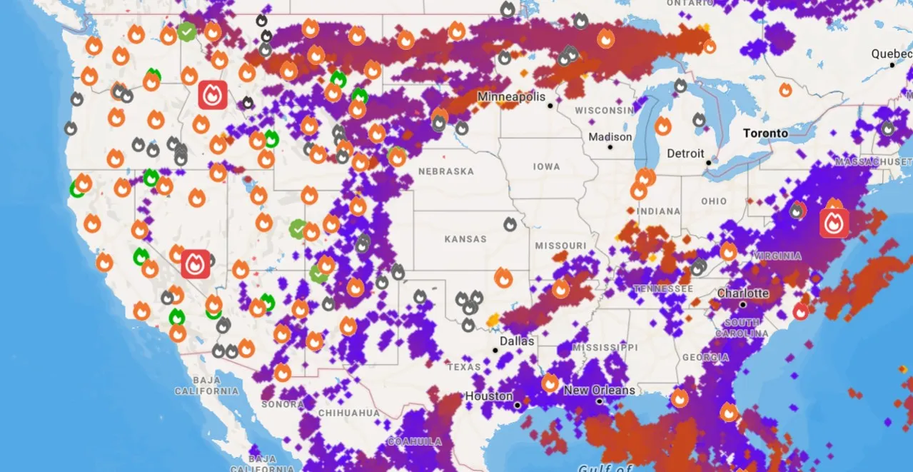
...
Jul 15, 2025 at 02:05 PM EDT
Historic Grand Canyon Lodge destroyed in wildfires
The Grand Canyon Lodge on the North Rim has been destroyed by a wildfire that swept through the area.
Superintendent Ed Keable said that 50 to 80 buildings on the North Rim were lost, including the historic lodge, built in 1937, as well as the visitor center, gas station, employee housing and more.
The Dragon Bravo Fire, began as a controlled burn but rapidly spread amid the extreme heat, low humidity and strong winds in the area. It has already engulfed 5,000 acres.
No injuries were reported.
View 0 Comments
Submit Correction
View Editorial & AI Guidelines