
...

By Anna Skinner
Associate News Editor
0
Share
Newsweek is a Trust Project member
See more of our trusted coverage when you search.Prefer Newsweek on Googleto see more of our trusted coverage when you search.
Numerous meteorologists are sounding the alarm that several Great Plains states within Tornado Alley are facing the risk of a tornado outbreak this weekend.
In Tornado Alley, the typical tornado season runs from spring into early summer, with peak activity most often between April and June, when warm, moist air from the Gulf of Mexico frequently clashes with cooler air from the north and west, creating favorable conditions for severe thunderstorms capable of producing tornadoes.
People living in the impacted areas are urged to begin reviewing their severe weather plans now, before the storms hit.
Read More on Weather
...
Where Is Tornado Alley?
Tornado Alley is not an officially defined region but a commonly used term for parts of the central U.S. where tornadoes occur most frequently, especially strong and long-lived ones. Most definitions place Tornado Alley across the Great Plains, from northern Texas through Oklahoma and Kansas, into Nebraska and parts of Iowa and South Dakota.
Those areas sit at the crossroads of warm, moist air from the Gulf; cold, dry air from Canada; and dry air descending from the Rocky Mountains. When those factors combine, it can create powerful, rotating thunderstorms.
Severe Weather Outbreak Forecast This Weekend: Tornadoes, Large Hail
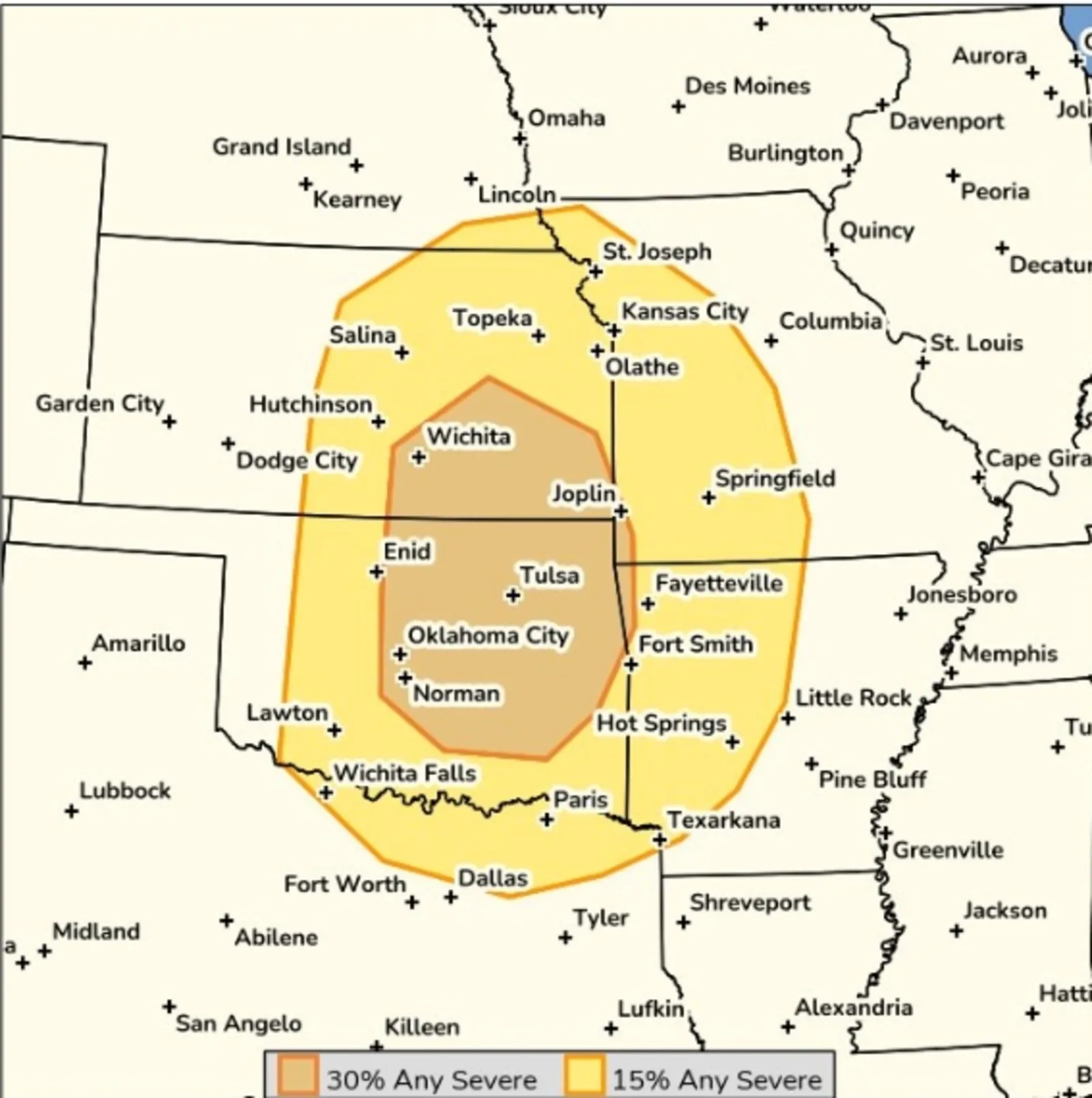
On Wednesday, the National Weather Service (NWS) Storm Prediction Center issued a forecast anticipating a 30 percent chance of severe storms forming on Sunday in parts of Oklahoma, Kansas, Missouri and Arkansas, with 15 percent chances expected in a much more widespread area, ranging from Texas into Nebraska and further into Missouri and Arkansas.
...
"Severe storms are possible Sunday afternoon and evening from eastern Kansas into eastern Oklahoma and adjacent areas of southwest Missouri and northwest Arkansas," a message for the forecast said. "Any sustained storms could become supercells capable of producing very large hail (well in excess of 2 inches in diameter) and strong tornadoes (EF2+)."
The message went on to stress that there was uncertainty around the forecast. While the environment is "very favorable for significant severe storms," the exact number, track and coverage of the storms is unclear.
Other meteorologists and stormchasers have drawn attention to the chance of significant storm outbreak.
"TORNADO OUTBREAK POSSIBLE THIS WEEKEND Southern Plains!" extreme stormchaser Reed Timmer posted on X. "A majority of forecast models are showing a classic dry line #tornado event across Oklahoma, Kansas, and North Texas on Saturday and Sunday, peaking on Sunday. Peak severe weather season is about to arrive to the Heart of Tornado Alley."
The greatest chance of a severe weather outbreak will be on Saturday and Sunday, MyRadar Weather posted on X.
"Given the exceptional amount of instability, or storm fuel, available, significant severe weather is expected," the post said. "The strongest storms will contain baseball-sized hail (or larger), straight line winds of 70+ mph and perhaps a few EF2+ tornadoes."
EF2 tornadoes are strong enough to rip the roofs off houses and uproot large trees.
How Are Tornadoes Rated?
The tornado rating scale used in the U.S. is called the Enhanced Fujita Scale, or EF Scale, and classifies tornadoes based on the damage they cause, not direct wind measurements. The scale has been in use since 2007, replacing the original Fujita Scale to better align estimated wind speeds with modern engineering standards.
- EF0 (65-85 mph): Light damage, such as broken tree branches or minor roof damage.
- EF1 (86-110 mph): Moderate damage, including overturned mobile homes and roof surfaces stripped off homes.
- EF2 (111-135 mph): Considerable damage, with roofs torn off houses and large trees uprooted.
- EF3 (136-165 mph): Severe damage, including entire floors of houses destroyed and heavy vehicles thrown.
- EF4 (166-200 mph): Devastating damage, with well‑built homes leveled and cars tossed long distances.
- EF5 (over 200 mph): Incredible damage, in which strong structures are swept from foundations and extreme destruction occurs.
Meteorologists stress that all tornadoes are dangerous, regardless of rating, and that EF classifications are determined after storms pass. During active weather, warnings do not include EF ratings because the damage has not yet been assessed.
Is Tornado Alley Moving?
Multiple peer‑reviewed studies and NOAA-supported analyses indicate that the highest tornado risk in the U.S. has moved eastward over the past several decades, away from the traditional Great Plains and toward the Midwest and Southeast.
Tornado Watch vs. Tornado Warning
It's possible local NWS offices will issue tornado watches or warnings this weekend, once the storms begin to take shape.
A tornado watch means atmospheric conditions are favorable for tornadoes to develop, but none have been confirmed yet. Watches are issued by the NWS Storm Prediction Center and typically cover large areas, sometimes spanning multiple counties or states. The alert is meant to signal heightened risk and prompt residents to stay weather‑aware, review safety plans and be ready to act if conditions worsen.
A tornado warning signals a much more immediate threat. Warnings are issued by local NWS offices when a tornado has been spotted by trained observers or indicated by radar. These alerts usually cover smaller areas, such as a city or part of a county, and mean there is imminent danger to life and property. When a warning is issued, residents are urged to take shelter immediately.
View 0 Comments
Submit Correction
View Editorial & AI Guidelines