...

By Anna Skinner
Associate News Editor
0
Share
Newsweek is a Trust Project member
See more of our trusted coverage when you search.Prefer Newsweek on Googleto see more of our trusted coverage when you search.
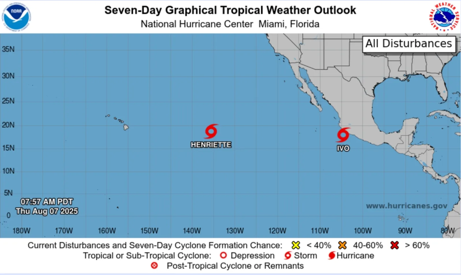
National Hurricane Center (NHC) meteorologists have issued a hurricane warning for the waters offshore of southwestern Mexico as Tropical Storm Ivo threatens to bring life-threatening impacts to the region in the coming days.
Why It Matters
Tropical Storm Ivo is the ninth named storm of the Eastern Pacific hurricane season. The Eastern Pacific season began on May 15, two weeks earlier than the Central Pacific and Atlantic hurricane seasons, and runs through November 30.
Read More on U.S.
Current forecasts show Ivo skirting the southwestern coast of Mexico before turning west out to sea. In addition to Ivo, the NHC also is monitoring Tropical Storm Henriette, about 1,280 miles east of Hawaii.
What to Know
Although Ivo, which is forecast to become a hurricane by Friday evening, is not expected to make landfall in Mexico, it will still cause weather hazards across the region.
...
Wind gusts
As of the most recent update from the NHC, Tropical Storm Ivo has maximum sustained wind speeds of 45 mph. Animated weather footage from windy.com shows that some gusts are higher than this, around 52 mph.
The strongest winds are gusting offshore.
Rain accumulation
NHC forecasts that Tropical Storm Ivo will produce widespread amounts of 2 to 4 inches of rain, with some locations seeing totals as high as 6 inches, across portions of the Mexican states of Guerrero, Michoacan de Ocampo and Colima through Friday.
Rain accumulation is expected to be highest offshore over the next three days, a windy.com map showed.
The NHC warned that the high rainfall totals will "result in an elevated risk for flash flooding."
Waves
Since the storm is not expected to make landfall, some of the most impactful hazards from Tropical Storm Ivo will be dangerous surf.
"Swells generated by Ivo will be affecting the southwestern coast of Mexico during the next couple of days," the NHC warned. "These swells are likely to cause life-threatening surf and rip current conditions. Please consult products from your local weather office."
Current wave heights off the southwestern coast of Mexico are around 11 feet, windy.com showed.
The National Oceanic and Atmospheric Administration (NOAA) has forecast a below normal hurricane season for the Eastern Pacific with 12 to 18 named storms. Of those, five to 10 will likely become hurricanes, and two to five could develop into major hurricanes.
Matthew Rosencrans, the lead for NOAA's seasonal hurricane outlook, told Newsweek that NOAA will not issue a revised update for the Eastern Pacific season, as storms usually peak from July to September.
Rosencrans added that the "early ramp-up" to the season was "a little surprising," but that the Eastern Pacific is performing below average in terms of total activity. Although there have been several storms, Rosencrans said most have been weak and short-lived.
What People Are Saying
AccuWeather Lead Hurricane Expert Alex DaSilva said in a report: "A large swath of 1-2 inches of additional rain is expected from western Guerrero to southern Nayarit, Mexico. The heaviest rain will be closest to the coast with an AccuWeather Local StormMax™ of 5 inches."
DaSilva added: "Ivo will continue to bring dangerous seas, rough surf and strong rip [currents] to the coast of Mexico into this weekend."
What Happens Next
The NHC will continue issuing updates as the situation develops. Residents and visitors to southwestern Mexico should monitor local weather guidance as the storm progresses.
View 0 Comments
Submit Correction
View Editorial & AI Guidelines