10
Loading video...

By Joe Edwards
Reporter
0
Share
Newsweek is a Trust Project member
See more of our trusted coverage when you search.Prefer Newsweek on Googleto see more of our trusted coverage when you search.
Recent spaghetti models indicate that Tropical Storm Erin, which meteorologists warn has the potential to strengthen into a hurricane by Friday, is unlikely to directly hit the U.S. coast.
Why It Matters
Forecasters say Erin could develop into the first major hurricane of the 2025 season.
Read More on News
It is the fifth named system of the Atlantic hurricane season so far, following Andrea, Barry, Chantal, and Dexter—none of which developed into hurricanes.
Chantal brought heavy rain and flooding to North Carolina in early July.
What To Know
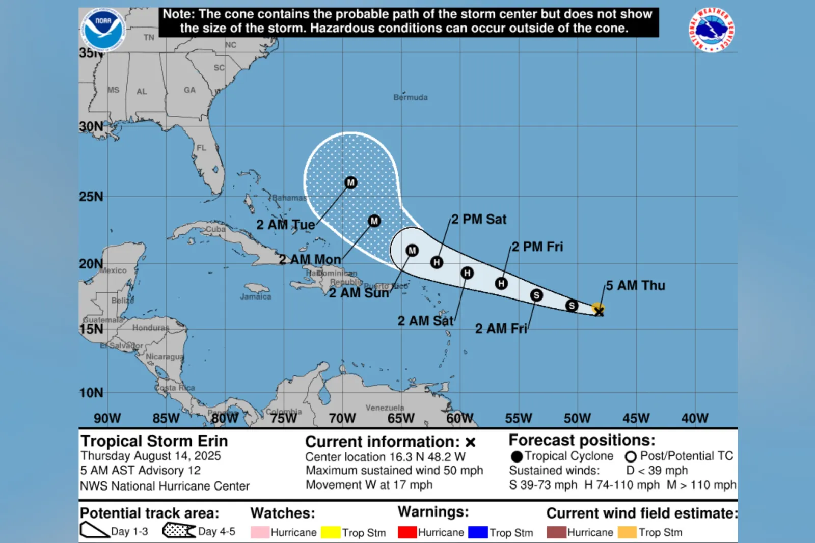
Some spaghetti models—computer models that illustrate potential storm paths—previously showed the system had a chance of tracking over Florida. However, more recent models suggested a consensus that it would instead curve north and east over the Atlantic Ocean.
The National Hurricane Center (NHC) previously said that the storm's path had shifted south.
...
In its most recent update, the agency said Erin was moving west at around 17 miles per hour, with maximum sustained winds near 50 mph.
"On the forecast track, the center of Erin is likely to move near or just north of the northern Leeward Islands over the weekend," it said.
The NHC added: "Gradual strengthening is forecast during the next day or so, with more significant intensification possible on Friday and Saturday."
Forecasters at AccuWeather said on Wednesday that there was a 70 percent chance that Erin would not directly impact the U.S. East Coast.
Although direct impacts were unlikely, the outlet indicated that Erin could still present hazards to coastal communities.
"Despite being hundreds of miles offshore, Erin will likely bring dangerous rough surf, deadly rip currents, and possible erosion issues to beaches along the East Coast. The Outer Banks and Atlantic Canada could see some of the roughest beach conditions next week," AccuWeather lead hurricane expert Alex DaSilva said in an advisory shared with Newsweek.
What People Are Saying
AccuWeather lead hurricane expert Alex DaSilva told Newsweek on Wednesday: "AccuWeather still expects Erin to stay north of the Leeward Islands …
"While the core of the storm should stay to the north. There can be some wind and rain impacts in the islands. Very large waves and dangerous rip currents will be a big concern on the islands as well, especially the north facing beaches."
The National Hurricane Center said on X, Thursday: "Locally heavy rainfall, high surf and rip currents, and tropical-storm force winds could occur in portions of the northern Leeward Islands, the Virgin Islands, and Puerto Rico this weekend as the core of #Erin passes north of those islands. Interests in these areas should continue to monitor the progress of Erin."
What Happens Next
August and September are typically the busiest months of the Atlantic season, the NHC says.
The Atlantic hurricane season runs from June through November.
View 0 Comments
Submit Correction
View Editorial & AI Guidelines