...

By Emma Marsden
Reporter
0
Share
Newsweek is a Trust Project member
See more of our trusted coverage when you search.Prefer Newsweek on Googleto see more of our trusted coverage when you search.
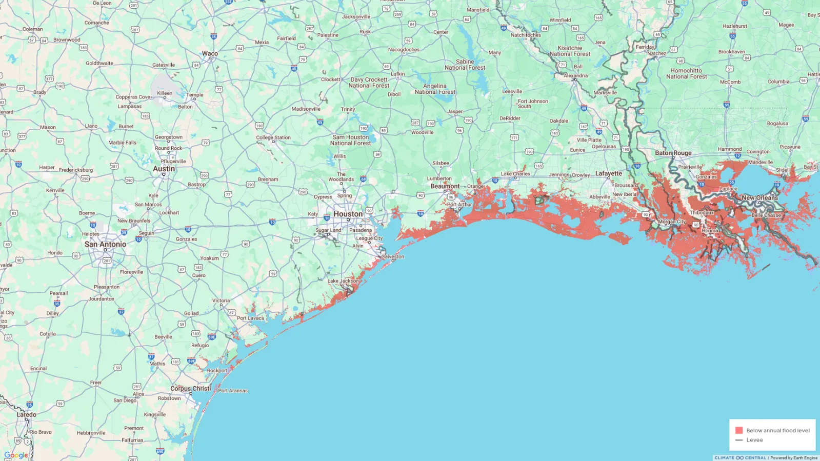
A recently created map paints a concerning picture for Texas' future, highlighting the potential impact of rising sea levels and increased flooding due to climate change and coastal erosion.
The map, developed by climate scientists and researchers at Climate Central using advanced predictive modeling, and published by the East Texas Sports Network (ETSN), shows that several Texas cities could face significant flooding or even be partially underwater by 2050.
Coastal cities are most at risk. As reported by ESTN, the most recent climate projections suggest Texas will experience 10 to 12 inches of sea level rise by 2050, which could drastically change things for the Texan coastline.
Read More on U.S.
The most vulnerable areas include low-lying cities along the Gulf Coast, such as Galveston, Caplan, Jamaica Beach, Freeport, Cameron, and Corpus Christi. Many Gulf Coast cities already grapple with frequent flooding and storm surges, challenges that are projected to worsen as sea levels rise and hurricanes intensify.
Without serious mitigation efforts, cities like Galveston could see large portions submerged or rendered uninhabitable.
In a statement to Newsweek on Friday Galveston Mayor Craig Brown said: "Climate Change and its effects on Coastal Cities is taken very seriously in Galveston. In response to this we are intensifying our efforts to partner with our State and Federal Government in the building of a Surge Suppression System."
...
The map also identifies more inland or non-coastal cities that could be affected, such as Beaumont, and parts of Orange County, as well as cities such as Lake Jackson and Port Arthur.
The map raises pressing questions about infrastructure, housing, and emergency preparedness. Major highways, energy facilities, and water systems in these cities could be in the potential flood zones, posing challenges for planners and policymakers.
The creators of the map are Climate Central, an independent group of scientists and communicators who research and report the facts about the changing climate and how it affects people's lives.
Peter Girard, vice president of communications for Climate Central, told Newsweek on Friday: "This map shows areas whose elevation is lower than the level of a coastal flood expected to occur at least once per year, on average, by the year 2050.
"We sometimes see this projection confused with the high tide line—illustrated here—which represents projected sea level rise without the additional influence of a coastal flood.
"As seas rise, coastal flood risks in cities like Galveston will expand further inland, affecting far greater areas and potentially far more people and property than today. And as the pace of sea level rise accelerates, especially in the later half of this century, the impact of coastal storms is likely to extend much farther.
"The additional threat from rainfall during storms, which Climate Central's coastal risk screening tool doesn't show, compounds the risk.
"Places whose elevation is lower than projected water levels, whether that's during a coastal flood or merely at high tide, are clearly at risk. But that doesn't necessarily mean they're doomed. Defenses like levees and seawalls are already protecting some coastal areas in Texas, and as sea levels rise, others may be able to invest in solutions to reduce their risks.
"Time is a crucial factor in coastal communities' ability to protect themselves from rising seas. If carbon emissions can be reduced sharply and fast, the rate of sea level rise is projected to slow. That could give cities additional decades to plan, finance, and build defenses, which could be the difference they need to survive."
According to the Texas General Land Office (GLO), the average erosion rate for the 367 miles of the Texas coast is 4.1 feet per year.
"As steward of the Texas coast, the Texas General Land Office (GLO) is leading the fight against coastal erosion by implementing coastal erosion response projects and related studies to reduce the effects of and to understand the processes of coastal erosion as it continues to threaten public beaches, natural resources, coastal development, public infrastructure, and public and private property," the GLO said.
The government office advises that the Coastal Erosion Planning and Response Act (CEPRA) program and other grant programs at the GLO "implement erosion response projects and studies through collaboration and a matching funds partnership with federal, state, and local governments, non-profit organizations, and other potential project partners.
"Based on a cost/benefit analysis of recently executed CEPRA erosion response projects, the results determined that the state of Texas receives $4 in economic and financial benefits for every dollar of state funding invested in these projects."
The types of projects that are considered for CEPRA funding include beach nourishment on both the Gulf of Mexico and bay beaches, shoreline stabilization, habitat restoration and protection, dune restoration, and coastal erosion-related studies and investigations.
Newsweek contacted GLO for comment via email on Friday outside of regular working hours.
An interactive version of the map is below.
Update 12/06/24,10:15 a.m. ET: This article was updated with comment from Climate Central and Dr. Craig Brown, mayor of Galveston.
View 0 Comments
Submit Correction
View Editorial & AI Guidelines