...

By Emma Marsden
Reporter
0
Share
Newsweek is a Trust Project member
See more of our trusted coverage when you search.Prefer Newsweek on Googleto see more of our trusted coverage when you search.
A wide area of south-central Texas, including Austin and San Antonio, is under a Flood Watch until midday Monday, with forecasters warning residents to be "prepared to take action" as heavy rainfall raises the risk of flash flooding.
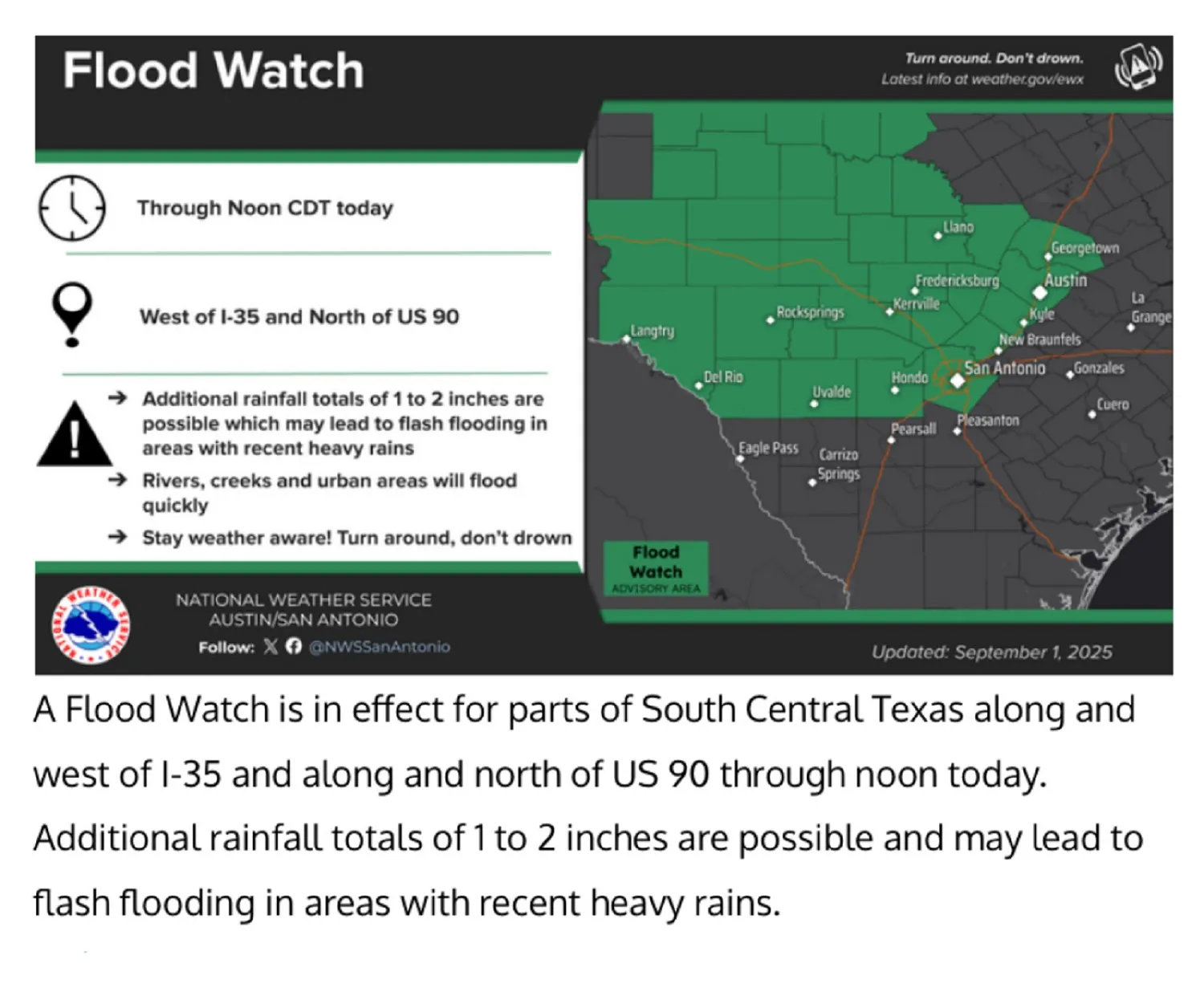
A map showing affected areas has been issued by the National Weather Service (NWS), part of the National Oceanic and Atmospheric Administration (NOAA).
Newsweek contacted NOAA for comment via email outside of regular working hours on Monday.
Read More on U.S.
Why It Matters
Texas has recently endured repeated bouts of severe weather, including devastating floods earlier this year, as reported by Newsweek. Consequently, the ground in many places is already saturated.
Hundreds of people were ordered to evacuate flood-threatened areas of Texas back in May as storms bringing torrential rains battered the state, with several people killed in weather-related incidents.
The NWS warns that additional rainfall this week could quickly overwhelm rivers, creeks, and drainage systems, threatening homes, roads, and critical infrastructure.
A map shows the affected areas along and west of I-35, as well as along and north of US 90.
...
What To Know
The Flood Watch, issued by the NWS Austin/San Antonio office, remains in effect for much of South-Central Texas until noon CDT on Monday.
A slow-moving cold front and abundant tropical moisture bring a risk of heavy rainfall to the region. Storm systems may bring 1–2 inches of rainfall, with isolated areas possibly seeing up to 8 inches.
Meteorologists stressed the importance of staying alert during the watch period. "Be prepared to take action should flooding develop," the NWS stated in its advisory.
Officials also urged residents not to drive through flooded roads, repeating the well-known warning: "Turn Around, Don't Drown."
The watch spans multiple counties, including Bandera, Bexar, Blanco, Burnet, Comal, Edwards, Gillespie, Hays, Kendall, Kerr, Kinney, Llano, Medina, Real, Travis, Val Verde, Williamson, as well as Hill Country, and the Rio Grande region, where "excessive runoff may result in flooding of rivers, creeks, streams, and other low-lying and flood-prone locations".
Major urban areas affected include Austin, San Antonio, Boerne, New Braunfels, Fredericksburg, and Uvalde, and the cities of Rocksprings, Georgetown, Del Rio, Kerrville, Hondo, Brackettville, San Marcos, and Leakey.
A portion of west-central Texas is also under the watch until 7 a.m. CDT Monday, including the counties of Brown, Coke, Coleman, Concho, Crockett, Irion, Kimble,
Mason, McCulloch, Menard, Runnels, San Saba, Schleicher, Sterling,
Sutton and Tom Green.
Forecasters caution that excessive runoff in affected regions could result in flooded low-lying areas, road closures, and dangerous driving conditions.
What People Are Saying
**The NWS in its advisory: "**Excessive runoff may result in flooding of rivers, creeks, streams, and other low-lying and flood-prone locations. Creeks and streams may rise out of their banks. Flooding may occur in poor drainage and urban areas. Low-water crossings may be flooded.
**"**Persons living along streams should stay alert and be prepared to take action if a warning or advisory is issued, or flooding is observed. You should monitor later forecasts and be alert for possible Flood Warnings. Those living in areas prone to flooding should be prepared to take action should flooding develop.
"Stay tuned to further developments by listening to your local radio, television, or NOAA Weather Radio for further information."
What Happens Next
The Flood Watch remains in effect until noon CDT Monday. If rainfall persists beyond that window, the advisory may be extended or upgraded to a Flood Warning in specific areas. The NWS flood safety map can be found here.
Emergency services are monitoring conditions, and residents are advised to avoid travel in known low-lying or flood-prone areas.
NWS urges residents in flood-prone areas to monitor updates and public safety alerts, and be prepared to act quickly should flooding develop, with evacuation routes and emergency plans ready.
View 0 Comments
Submit Correction
View Editorial & AI Guidelines