...

By Kate Plummer
Senior US News Reporter
0
Share
Newsweek is a Trust Project member
See more of our trusted coverage when you search.Prefer Newsweek on Googleto see more of our trusted coverage when you search.
El Niño conditions are expected to return and influence global temperatures and rainfall patterns, including in the United States, in the coming months, according to the United Nations.
The weather phenomenon, which is part of a recurring global weather cycle, has an 80 percent chance of forming between June and August this year and a 90 percent chance to do so before November, the World Meteorological Organization (WMO), the UN’s leading climate body, said on Tuesday.
The last El Niño cycle, in 2023-24, was one of the five strongest on record and contributed to record global temperatures in 2024, said the WMO. Forecast models suggest this next one will be at least moderate in strength, with the potential to become strong.
Read More on News
UN Secretary-General António Guterres warned the event should be treated as an “urgent climate warning,” saying El Niño “will pour fuel on the fire of a warming world,” with impacts that could intensify and spread rapidly across borders.
...
Where El Niño Is Expected To Hit Hardest
The WMO data showed that, from late April to mid-May, sea-surface temperatures in the central-eastern equatorial Pacific — the key monitoring region—were approaching El Niño thresholds.
At the same time, the Southern Oscillation Index—the atmospheric component of El Niño—is also consistent with emerging El Niño conditions.
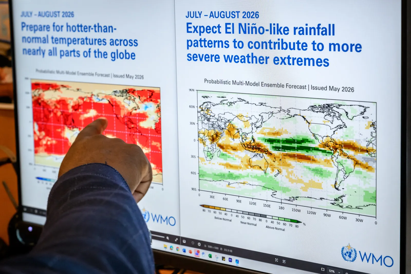
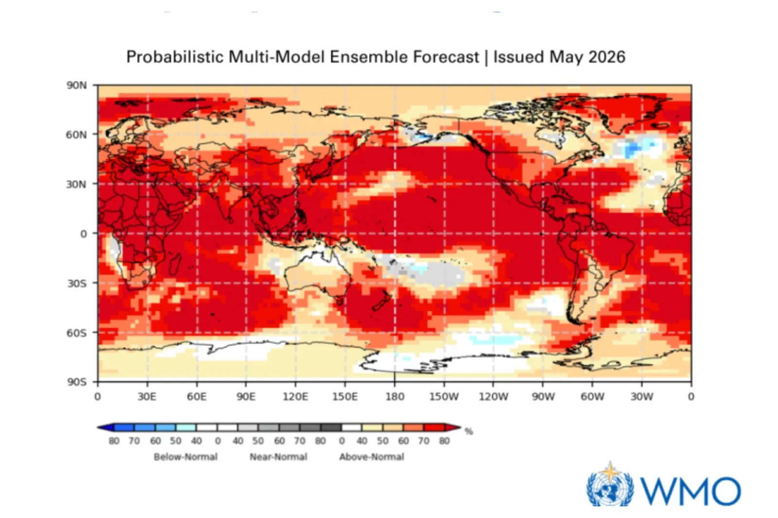
Forecasts suggest widespread impacts across much of the globe, with above-average temperatures likely in nearly all regions between June and August.
The WMO’s multi-model outlook shows particularly strong warming across large parts of the Pacific, Africa, Asia and the Americas, increasing the risk of heat waves and compounding climate hazards.
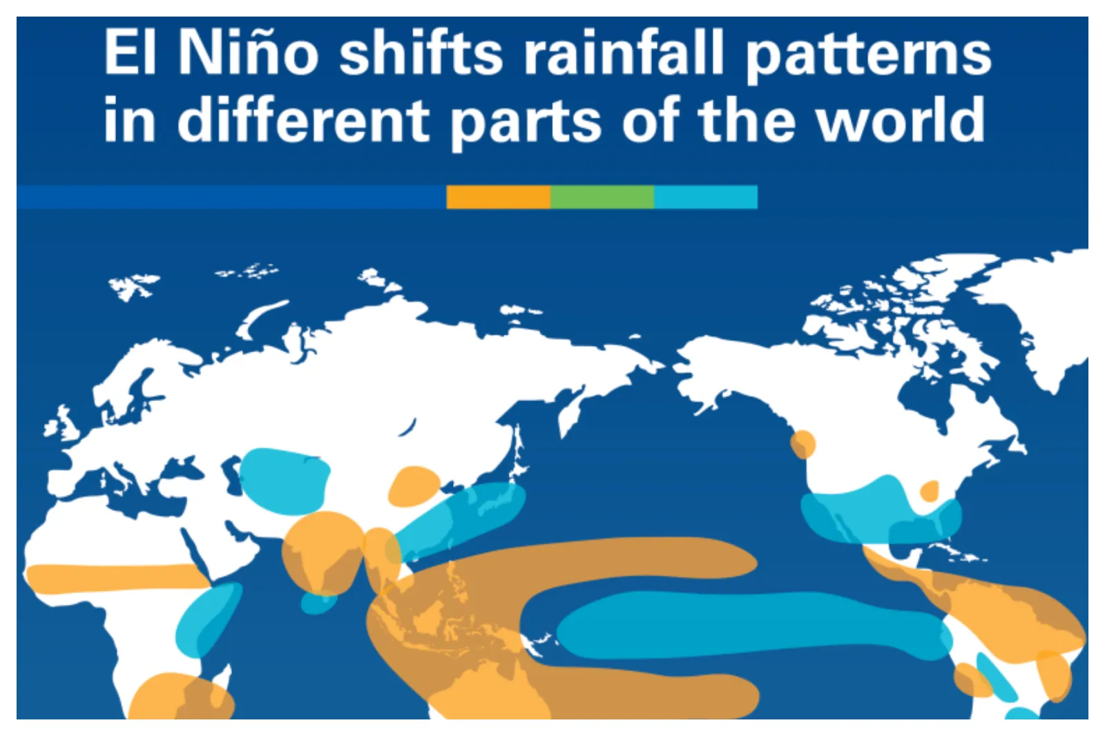
Rainfall patterns are also expected to shift along typical El Niño lines, bringing wetter conditions to parts of the southern United States, southern South America, the Horn of Africa and central Asia,
Meanwhile, the likelihood of drier conditions across Central America, northern South America, the Caribbean, Australia and parts of southern Asia will increase.
Shifting ocean temperatures may also influence storm activity, with increased cyclone potential in the central and eastern Pacific while there could likely be a quieter Atlantic hurricane season.
...

...
...
What Is an El Niño ?
El Niño, marked by warming Pacific waters, and La Nina, its cooling counterpart, are phases of the El Nino-Southern Oscillation, a major influence on global weather. This cycle shifts irregularly every two to seven years, driving predictable swings in ocean temperatures and altering typical wind and rainfall patterns across the tropics.
El Niño events can cause wetter conditions in the southern states, drier conditions in parts of the north and shifts in temperature extremes. A super El Nino could suppress hurricane activity in the Atlantic but create more hurricanes in the Pacific.
Forecasters generally define a super El Niño as water temperatures being at least 2 degrees Celsius warmer than average over several months. There have been five super El Niños since 1950.
In the U.S., El Niño is known to influence myriad weather events, such as a weaker Atlantic hurricane season and heavier rains during the Southwest's monsoon season, AccuWeather senior meteorologist Tom Kines previously told Newsweek.
Although some of El Niño's impacts won't get underway until well into the winter, an increased risk of rain showers in the Rocky Mountains and Southwest could begin as early as June.
There have been several similar warnings about a coming El Niño.
Last month, the National Oceanic and Atmospheric Administration (NOAA) reported a 60 percent chance of an El Niño developing between May and July, and there is at least a 50-50 chance it could develop into a super El Niño, according to model forecasts.
Meanwhile, "El Niño is likely to emerge soon," the Climate Prediction Center said in its latest update on Friday, giving an 82 percent chance of emergence between May and July.
In his statement, Guterres added: "El Niño conditions will pour fuel on the fire of a warming world. Impacts will hit even harder, travel even farther, and cross borders with devastating speed. The only effective response is climate action equal to the crisis – ending the addiction to fossil fuels, accelerating the shift to renewables, protecting the most vulnerable, and delivering early warning systems for all.”
WMO Secretary-General Celeste Saulo urged governments and agencies to prepare for the potential impacts, warning of increased risks from drought, heavy rainfall and heatwaves.
She said early warnings and seasonal forecasts would be critical in helping governments, humanitarian agencies and climate-sensitive sectors such as agriculture, energy and water management respond effectively.
View 0 Comments
Submit Correction
View Editorial & AI Guidelines