...

By Anna Skinner
Associate News Editor
0
Share
Newsweek is a Trust Project member
See more of our trusted coverage when you search.Prefer Newsweek on Googleto see more of our trusted coverage when you search.
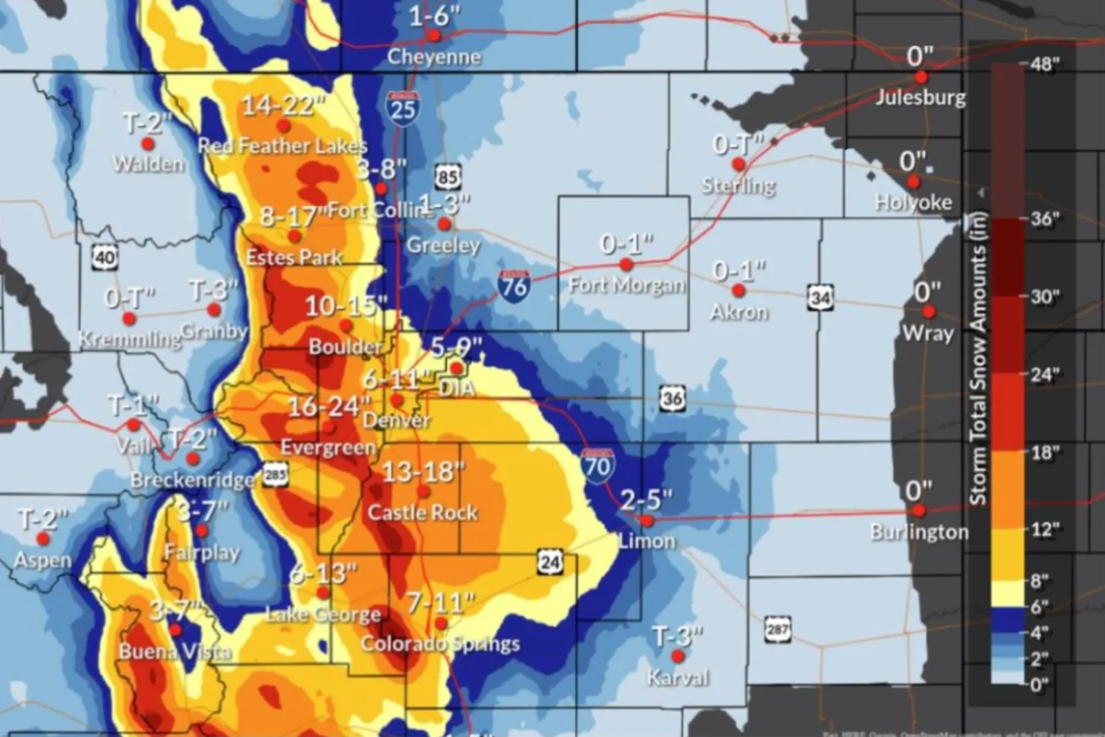
The National Weather Service office in Boulder, Colorado, updated its snowfall prediction map on Thursday morning as a winter storm gripped much of the state.
Denver is bracing for what could be the city's "biggest snowstorm of the season" as a late winter storm threatens to bring up to 15 inches of snow to the city by Friday. The storm system also will plunge temperatures in the central Colorado region to 37 degrees on Thursday, about 15 degrees below normal for this time of year.
The NWS office in Boulder said that more snow is on the way.
Read More
California Warned of Massive Blackouts as Urgent Weather Alert Issued3 min read

‘Supercharged’ Flowers Blooming After California’s Atmospheric River3 min read

Map Shows Winter Weather Warnings as Storm Grows3 min read

...
"MORE SNOW!!! After a lull along portions of the I-25 Corridor this morning, snow is expected to become more widespread and heavier again this afternoon and evening," the office posted on X, formerly Twitter, on Thursday morning. "Another 6-12" coming for Denver metro, and 14-26" more for the foothills. Lighter amounts farther east."
In a follow-up post, NWS Boulder shared radar footage of the storm.
"It's still snowing hard in the Denver metro & foothills. However, you will notice a 'back edge' to the snow approaching Denver from the northeast," the office said. "This will result in a lull in snow during the late morning. More widespread & intense snow will redevelop later this afternoon."
Heavy snow has already accumulated in the Denver area since the storm began on Wednesday. NWS meteorologist Paul Schlatter told Newsweek that anywhere from 6 to 10 inches has fallen in central Denver, with the region's western suburbs receiving 12 to 16 inches and the southern suburbs receiving 14 to 18 inches.
"The fascinating thing is that the Denver International Airport, which is in the far northeast part of Denver, barely has half an inch," Schlatter said. "There's a huge difference between the central and eastern parts of Denver."
Schlatter said the heaviest snow will end by midnight, although light snow will continue until early morning on Friday. Schlatter suggested people avoid traveling unless necessary and to "take it easy" shoveling snow, given the heavy, wet consistency.
According to the snowfall map shared on Wednesday, Evergreen is expected to receive the most snowfall, up to 37 inches. Up to 35 inches is forecast for Red Feather Lakes. Up to 26 inches is forecast for Castle Rock, and Estes Park and Lake George could each see 24 inches.
As of Thursday, much of Colorado was under a winter storm warning or a winter weather advisory. The warning and advisory also extended into Wyoming, New Mexico, Arizona and Utah.
Strong winds were gusting on the back end of the storm and were impacting much of California and Nevada as of Thursday. Later this week, the same storm system causing the heavy snow in the West will bring a threat of thunderstorms and tornados to 60 million people across the U.S. south, Midwest and Plains states.
...
View 0 Comments
Submit Correction
View Editorial & AI Guidelines