...

By Anna Skinner
Associate News Editor
0
Share
Newsweek is a Trust Project member
See more of our trusted coverage when you search.Prefer Newsweek on Googleto see more of our trusted coverage when you search.
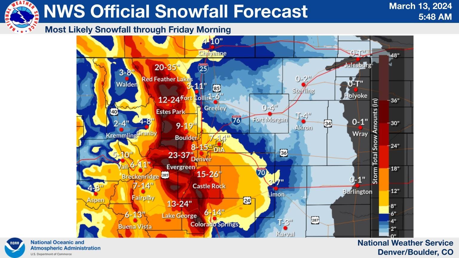
The National Weather Service (NWS) office in Boulder released a map Wednesday morning showing which Colorado cities were expecting the heaviest snowfall with the approaching winter storm.
Denver is bracing for what could be the city's "biggest snowstorm of the season" as a late winter storm threatens to bring up to 15 inches of snow to the city by Friday. The storm system also will plunge temperatures in the central Colorado region to 37 degrees by Thursday, about 15 degrees below normal for this time of year.
"Heavy snowfall for areas in/near the Front Range Mountains, Foothills & Palmer Divide including the greater Denver/ Boulder area," NWS Boulder posted on X (formerly Twitter) on Wednesday morning with the snowfall map. "Deteriorating conditions will [develop] this afternoon/tonight & continue into Thursday night. Conditions will slowly improve Friday."
Read More
‘Supercharged’ Flowers Blooming After California’s Atmospheric River3 min read

California Warned of Massive Blackouts as Urgent Weather Alert Issued3 min read

Before and After Pictures Show Key Difference in Nevada Snowpack3 min read

...
According to the map, Evergreen is expected to receive the most snowfall, up to 37 inches. Up to 35 inches is forecast for Red Feather Lakes. Up to 26 inches is forecast for Castle Rock, and Estes Park and Lake George could each see 24 inches.
NWS meteorologist Zach Hiris told Newsweek it is difficult to predict how much snow the Denver area will receive given that temperatures are in the 40s, causing precipitation to fall as rain. "How long [the rain] lasts will impact snowfall totals," he said.
Snowfall rates could change, making for more or less snow in the metropolitan areas depending on how the storm performs.
As of Wednesday afternoon, much of Colorado was under either a winter storm watch, winter storm advisory or winter storm warning, according to the NWS website.
In a follow-up post on X, NWS Boulder said that in Denver "rain will transition to snow this evening."
"There's potential for heavy snowfall rates during the late evening but high uncertainty exists," the office wrote.
If more than 5.5 inches of snow falls at Denver International Airport, the storm will go down as the "snowiest storm of the winter," AccuWeather reported earlier this week. Most recently, Denver's largest snowfall occurred last month, when 5.5 inches of snow fell within 24 hours on February 3.
The heavy snow could make travel impossible in some areas, the NWS warned.
"Deep snow will make travel nearly impossible, especially late tonight through Thursday afternoon," NWS Denver said in the winter storm warning. "Visibility will be poor in heavy snowfall. Scattered power outages will be possible."
Snowfall rates could reach up to 2 inches per hour in the Denver metropolitan area on Wednesday night and during the day on Thursday, according to a graphic shared on X by NWS Boulder.
View 0 Comments
Submit Correction
View Editorial & AI Guidelines