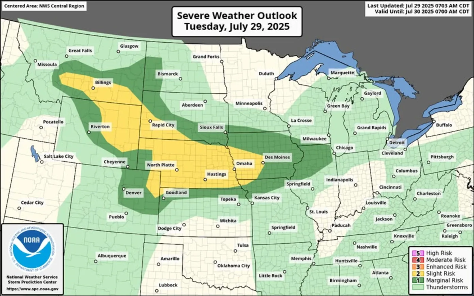
Map severe thunderstorms

By Anna Skinner
Associate News Editor
0
Share
Newsweek is a Trust Project member
See more of our trusted coverage when you search.Prefer Newsweek on Googleto see more of our trusted coverage when you search.
Eight states in the Northern U.S. could see severe thunderstorms accompanied by hail and damaging winds on Tuesday.
Why It Matters
On Tuesday, National Weather Service (NWS) meteorologists were warning people across eight states that they faced the threat of thunderstorms on Tuesday afternoon. Although no thunderstorm warnings were in place as of around noon Eastern time on Tuesday, thunderstorms can develop rapidly and prompt urgent warnings to take shelter. Residents in the affected areas were urged to monitor their local weather forecasts and remain ready to take shelter should a storm develop.
Read More on U.S.
The dangerous weather comes a day after parts of the Northern Plains faced hurricane-force winds on Monday. NWS Storm Prediction Center meteorologist Andrew Lyons told Newsweek it is not uncommon for the Northern Plains to see severe weather this time of year.
...
What to Know
On Tuesday, the NWS posted a map and brief forecast about the impending storms on Facebook.
"Today: Severe thunderstorms are expected from southern Montana into the central High Plains, and across much of Nebraska and western Iowa," the post said. "Areas of damaging winds will be possible, with hail most likely over western areas."
Eight states are at a "slight" risk for storms, which means scattered severe storms are possible. An even more widespread area was under a "marginal" risk, which indicates severe storms will be localized and isolated.
Severe storms have the greatest chance of occurring in parts of Montana, Wyoming, South Dakota, Nebraska, Colorado, Kansas, Iowa, and Missouri on Tuesday afternoon and into the evening.
As of Tuesday around noon Eastern time, no states in the forecast area had a severe thunderstorm warning or watch in place.
What People Are Saying
NWS in a Tuesday morning forecast: "Shortwave energy interacting with anomalous moisture and instability along a surface front will produce afternoon/evening storms across portions of the Northern/Central Plains today. Storms initiating in eastern Montana are forecast to congeal into a mesoscale convective system and sweep across parts of the Dakotas, Wyoming, Nebraska and Iowa by Wednesday morning. Slight risks of excessive rainfall (at least 15% chance) and severe thunderstorms (level 2/5) are in effect for many of the aforementioned areas with damaging winds and hail possible."
NWS Bismarck, North Dakota, said in a hazardous weather outlook: "A few thunderstorms are possible this afternoon and early evening. Severe weather is not anticipated."
NWS Rapid City, South Dakota, said in a hazardous weather outlook: "There is a slight risk (level 2 of 5) of severe thunderstorms today, meaning that scattered severe storms are possible. Primary hazards include large hail and damaging winds."
What Happens Next
People in the affected areas are urged to monitor local weather alerts throughout the day. After the storms move through the Northern Plains, NWS meteorologists anticipate they could bring a slight risk of excessive rainfall to parts of the Midwest on Wednesday.
View 0 Comments
Submit Correction
View Editorial & AI Guidelines