10
Loading video...

By Joe Edwards
Reporter
0
Share
Newsweek is a Trust Project member
See more of our trusted coverage when you search.Prefer Newsweek on Googleto see more of our trusted coverage when you search.
New outlooks issued by federal forecasters indicate what winter could bring across the United States, as a strengthening El Niño is expected to influence conditions across the country.
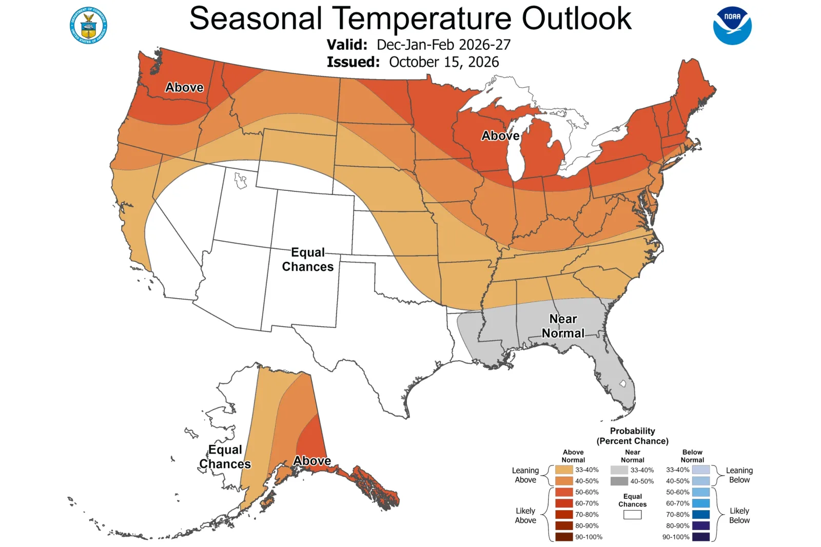
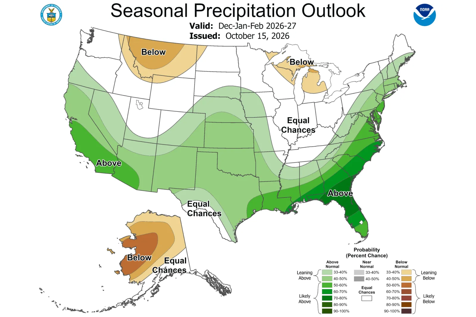
The Climate Prediction Center (CPC) published its latest outlooks for the December to February period on Thursday. The maps show an increased likelihood of above-average temperatures across the northern tier and wetter-than-average conditions in parts of the Southern U.S.
Newsweek reached out to the CPC via email for comment.
Read More on Weather
Scott Handel, lead meteorologist at the CPC, told Newsweek previously that the outlooks indicate the probability of seasonal temperatures and precipitation being above, near or below normal, rather than forecasting specific values or individual weather events.
An area favored to have a warmer-than-normal winter could therefore still experience significant cold snaps. Similarly, Handel explained, Alaska being more likely than Florida to experience above-normal temperatures would not mean Alaska’s actual temperatures will be higher.
...
What the Latest Maps Show
The CPC’s new outlooks show higher chances of above-normal precipitation across much of the West and East Coasts, along the southern tier of the country, and into the Central Plains. Drier-than-average conditions are more likely in Michigan and northeastern Wisconsin, as well as parts of Washington, Idaho, Montana, and North Dakota, according to the map.
Meanwhile, the outlooks suggest above-normal temperatures are most likely across the northern tier of the country and much of Alaska. Above-normal temperatures are also favored across parts of California, the central U.S., the Ohio Valley and the Mid-Atlantic, although generally with lower probabilities. Near-normal temperatures appear likely along much of the Gulf Coast.
...
What Is El Niño?
El Niño is a naturally recurring climate pattern associated with warmer Pacific waters that can influence temperatures and rainfall worldwide.
In the U.S., typical El Niño effects can include stormier weather across southern regions, drier conditions in some northern areas, and changes in hurricane activity.
The CPC said earlier this month that El Niño had continued to strengthen, with a greater than 83 percent chance for a “strong-to-very strong” event likely through January to March 2027. The agency added that chances remained high for “a historic event that would exceed the strength of previous El Niño events dating back to 1950.”
Handel told Newsweek that “El Niño was the most important driver” in the CPC’s previous winter outlooks, issued in September, as the level of confidence for a historic event at the time was “extremely rare.”
Contact Newsweek editors on this story: Matthew Robinson and Sam Wilson.
View 0 Comments
Submit Correction
View Editorial & AI Guidelines