
...

By Amanda Greenwood
Associate News Editor
0
Share
Newsweek is a Trust Project member
See more of our trusted coverage when you search.Prefer Newsweek on Googleto see more of our trusted coverage when you search.
Millions of Americans across a wide span of the central U.S. are under “Red Flag Warnings” on Thursday.
The National Weather Service (NWS) warns that any spark could rapidly turn into a fast-moving wildfire, and is, therefore, advising residents to avoid any outdoor burning until conditions improve.

...
Read More on News
A Red Flag Warning is an alert issued by the NWS to flag dangerous, fire-friendly conditions—typically a volatile mix of strong winds, very dry air, and warm temperatures—that can lead to extreme fires and rapid spread if a fire starts.
While a Red Flag Warning doesn’t mean a wildfire is currently burning, it does mean that the environment is primed for fire ignition and fast growth.
Below is a state-by-state look at where the warnings have been issued, why they’re in place, what people should do to reduce risk, and whether fire risk conditions are expected to last into the weekend.
Oklahoma
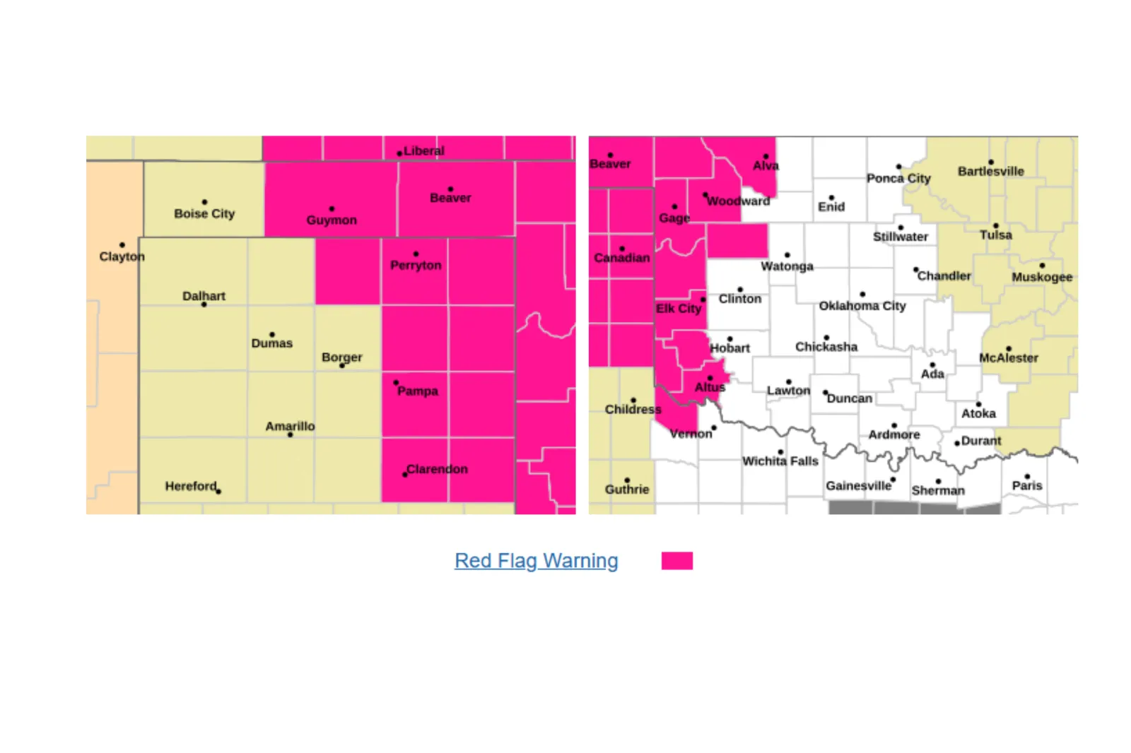
...
Parts of western Oklahoma (and adjacent parts of north Texas) are under Red Flag conditions on Thursday, with hot temperatures, low humidity, and gusty winds combining to elevate fire danger. In the NWS Norman forecast area, conditions around Woodward show a warm, windy pattern that can contribute to rapid fire spread.
Why it’s happening: According to the NWS, humidity is as low as 15 percent. For context, according to Biology Insights, a "normal" level of humidity sits between 30 and 60 percent. At 15 percent, the air is incredibly dry, which means the grass and brush are likely to catch fire easily and burn quickly. Alongside the low humidity, 40 mph wind gusts could spread any flames rapidly.
What it means for residents: Even small fires—yard debris or a roadside spark—can escalate quickly. Fire crews may find it more difficult to suppress fires because the strong winds and low humidity could exacerbate the flames.
Texas
Alongside northern parts of Texas, the warnings also extend into eastern Texas, including counties near the Red River, including Lipscomb, Hemphill, Wheeler, and Collingsworth. Forecasts show low humidity, very hot temperatures in the 90s, and periods of gusty, 30 mph winds, through Thursday.
Why it’s happening: The heat, dry air and unpredictable gusty winds are turning vegetation and grasses into fire-friendly tinder.
What it means for residents: Avoid activities that can generate sparks—especially on rural roads and near dry grass. Vehicle exhaust, dragging chains, and equipment use can all become ignition sources in these conditions.
South Dakota

...
Red Flag Warnings are in effect across parts of northeastern and west‑central South Dakota, including the Aberdeen forecast area, which covers Spink, Clark, Codington, Hamlin, Deuel, Stanley, Sully, Hughes, Hyde, Hand, Jones, Lyman, and Buffalo counties, where winds up to 50 mph and extremely dry air are creating hazardous conditions.
Why it’s happening: Strong winds paired with low humidity can make it easier for fires to start and harder to control—especially in open terrain where grass fires can spread quickly.
What it means for residents: Be prepared for reduced visibility at times if blowing dust develops, and expect local officials or land managers to restrict burning or outdoor fire use.
Minnesota
Warnings include parts of central, southwest, and west central, and south central Minnesota—including Brown, Watonwan, and Martin counties—where the NWS is tying critical fire risk conditions to strong winds and dry air during the daytime hours on Thursday and even into Friday in some areas.
Why it’s happening: Wind feeds oxygen to flames and can carry embers into nearby dry material, so even slightly dry conditions can spark fires easily.
What it means for residents: Residents in affected areas should avoid burning debris. If they must mow or complete yard work, they shouldn’t use any tools or equipment that involve engines or blades that can strike rocks and spark.
Nebraska

...
Red Flag Warnings are in effect across parts of western and north-central Nebraska—including the North Platte region, the eastern Panhandle, the Sandhills, and the Frenchman Basin—and extend into northeast Nebraska in the Omaha/Valley forecast area.
Why it’s happening: The NWS is warning of strong winds, reaching up to 40 mph, plus dry land and low humidity (10 percent), which is likely to create extreme fire conditions in certain areas.
What it means for residents: People should keep vehicles off dry grass, secure trailer chains, and delay any welding or grinding work outdoors.
Kansas

...
Southwest Kansas—including the Dodge City region—faces Red Flag conditions alongside very warm temperatures and periodic gusty winds reaching up to 55 mph in some cases.
Why it’s happening: Dry air and wind can turn small sparks into major fire problems, particularly in the driest grassland areas where fire spread rates can be high.
What it means for residents: Residents are being urged to treat any sign of smoke or flames as an emergency. If they spot any signs, they should call 911 early—waiting even a few minutes can matter under Red Flag conditions.
Colorado

...
Parts of northeast Colorado and the Gunnison Basin are under Red Flag Warnings through Thursday.
Why it’s happening: Low humidity (13 to 18 percent) and gusty winds (reaching 35 mph) can quickly dry out fuels, especially during warm afternoons, increasing the chance of rapid fire spread.
What it means for residents: Expect tight restrictions on open flames in some areas. Campers and hikers should avoid campfires entirely and use only contained, permitted cooking methods, where allowed.
North Dakota

...
Warnings cover broad areas of western and central North Dakota, and extend into eastern North Dakota as well, including regions near Grand Forks.
Why it’s happening: Dry air and strong winds reaching up to 55 mph are a dangerous pairing on grass and prairie land.
What it means for residents: Consider postponing outdoor projects that involve heat, friction, or sparks (sawing metal, grinding, chainsaws). Keep water and a shovel accessible if you’re in a rural area—though the best step is avoiding ignition sources entirely.
Iowa

...
Red Flag Warnings also reach into parts of northwest Iowa, including areas around Sioux City, where local NWS forecasts warn of dry air and strong wind gust potential.
Why it’s happening: Gusty winds and low humidity can turn roadside and field fires into quickly moving fronts, making suppression difficult, if fires do catch.
What it means for residents: Don’t toss cigarettes; avoid parking in tall grass; and be cautious with anything that produces a hot ember (fire pits, charcoal, burn piles).
Montana
Red Flag Warnings are in place across parts of northeastern Montana, including the Glasgow area, where the forecast shows very strong, sporadic winds—a major accelerant for fire spread.
Why it’s happening: High winds combined with dry grass and vegetation can create fast-changing, dangerous fire behavior, and can spread embers into new ignition points well ahead of an existing fire.
What it means for residents: Avoid burning and secure anything that could spark (ATVs, chains, or towing equipment). Wind-driven fires can also threaten powerlines and infrastructure, potentially causing outages in extreme cases.
What People Should Do (and Not Do) Under a Red Flag Warning
Do:
- Postpone outdoor burning entirely—this includes debris piles, burn barrels, and any agricultural burning.
- Avoid sparks: Delay welding, grinding, mower use in dry fields, and target shooting in grassy areas.
- Secure tow chains and avoid dragging metal—check trailers and tires before driving rural routes.
- Report smoke immediately. Early calls can stop small starts from becoming major incidents.
Don’t:
- Use fireworks or fire pits where restrictions apply (and avoid them entirely in windy conditions).
- Park vehicles on dry grass—hot exhaust systems can ignite fine fuels.
7-Day Outlook: Will Conditions Improve or Worsen?
Below is an NWS outlook for each affected state based on forecasts in or near Red Flag Warning areas:
- Oklahoma (Woodward area): Conditions will remain hot and windy through the rest of the week, although there could be a chance of storms on Thursday night, and rain showers are expected on Friday and Sunday. This suggests that the fire risks could be short-term.
- Texas (Quanah): It’s likely to remain very hot for the rest of the week with some storm chances on Thursday and Friday. The fire risk is high in the near term, but it could lessen if the storms arrive.
- South Dakota (Aberdeen area): Conditions look to remain windy and warm for the rest of the week, then there’s a chance of showers and storms from Saturday night. This means the risk of fire might gradually lessen as the chance of rain increases.
- Minnesota (Morris area): Windy periods are likely to continue, with chances for showers or storms at times, meaning the fire risk may fluctuate day-to-day, potentially easing when, or if, the rain comes.
- Nebraska (North Platte): Temperatures are likely to remain hot for the rest of the week, with some weekend rain expected. Conditions remain critical in the near term, with potential improvement if the weekend rain materializes.
- Kansas (Dodge City area): Hot and windy conditions will linger, but there are storm chances forecast for Thursday and over the weekend, which could alleviate fire risk conditions.
- Colorado (Gunnison areas): The warm, dry, and breezy weather is expected to last until Saturday, which could elevate fire risk. But cooler temperatures and increasing chances of rain and even snow on Sunday should help to reduce it.
- North Dakota (Grand Forks): The windy and warm weather is likely to last in the short term, but rain is expected, particularly from Sunday, which could reduce the critical risk of fire.
- Iowa (Sioux City area): Conditions will remain warm, but there is an increasing chance of storms from Friday night, which should reduce the immediate fire risk, but windy periods could still elevate the danger.
- Montana (Glasgow area): Very windy conditions are likely to continue in the short term, then periodic showers may develop from Saturday night. While the fire risk remains high while winds persist, there is some improvement possible if rain does fall.
View 0 Comments
Submit Correction
View Editorial & AI Guidelines