10
Loading video...

By Anna Skinner
Associate News Editor
0
Share
Newsweek is a Trust Project member
See more of our trusted coverage when you search.Prefer Newsweek on Googleto see more of our trusted coverage when you search.
The coldest air of the season will hit much of the U.S. this weekend and next week as an Arctic blast descends across the Lower 48, accompanied by subzero wind chills.
Why It Matters
Millions of people are bracing for frigid temperatures through Friday next week. Some of the states expecting the plunge in temperatures are familiar with the cold weather, but wind chill will also plummet the feels-like temperatures for states not as familiar with winter weather.
Read More on U.S.
As of Thursday morning, no cold weather advisories had been issued for the incoming weather, though some National Weather Service (NWS) meteorologists had issued special weather statements ahead of the incoming low temperatures.
...
What To Know
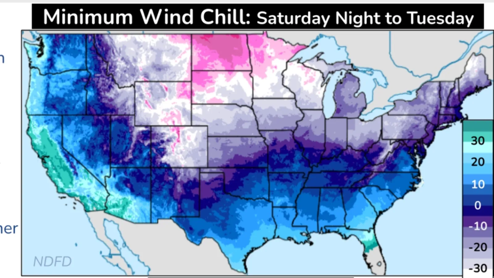
On Thursday morning, the NWS Weather Prediction Center issued key messages updating Americans about the impending weather. The map included with the messages showed that wind chill could dip into subzero territory for nearly every U.S. state. Subzero wind chills will stretch as far south as Texas.
Even for those states not expecting subzero wind chills, the incoming temperatures will be a far cry from what they typically see during this time of year. For example, in Florida, the forecast anticipates wind chill temperatures in the single-digit degrees Fahrenheit for part of the panhandle.
Further north, wind chill will make for temperatures that feel as cold as nearly 60 degrees below zero for far northern North Dakota. Wind chills around negative 40 are expected in parts of Wisconsin, Minnesota, South Dakota, Montana, Wyoming and Colorado.
Much of the central and Midwestern U.S. is expecting wind chills in the zero to negative-20 range.
Arctic air will arrive in the Rockies and Great Plains by Friday. It will cross the Deep South and Great Lakes by Saturday night and reach the Eastern Seaboard by Sunday.
In addition to cold temperatures, snow squalls are also possible in Montana, Wyoming and northern Colorado on Friday.
What People Are Saying
NWS Albuquerque meteorologist Matt DeMaria told Newsweek: "It's not uncommon for us to get these Arctic intrusions this time of year, but, that being said, it can still be very impactful." He urged people to look after each other, their pets, pipes and plants as the Arctic blast arrives.
NWS Mobile in a post on X, formerly Twitter: "We know there is a lot of discussion starting about the potential for winter weather next week. It's simply too soon to talk about any specifics. There are two scenarios we will be watching for. Regardless of the winter weather threat, it will turn very cold for early next week!"
NWS Weather Prediction Center wrote in a key message: "The Rockies, northern Plains, and Upper Midwest should see minimum wind chills of [-30 degrees Fahrenheit] or colder Saturday into Tuesday. This poses a great risk of hypothermia and frostbite to exposed skin. Have a cold weather survival kit if traveling.
"Below-zero wind chills are forecast to reach the Southern Plains and Ohio Valley by Sunday night into Tuesday. Hazardous cold weather likely lingers along the Gulf Coast and the Southeast U.S. through much of next week."
What Happens Next
Colder-than-average temperatures will likely stick around, according to the six- to 10-day temperature outlook from the NWS Climate Prediction Center. There is less of a chance of below-average temperatures in the eight- to 14-day outlook, though it remains possible.
View 0 Comments
Submit Correction
View Editorial & AI Guidelines