...

By Anna Skinner
Associate News Editor
0
Share
Newsweek is a Trust Project member
See more of our trusted coverage when you search.Prefer Newsweek on Googleto see more of our trusted coverage when you search.
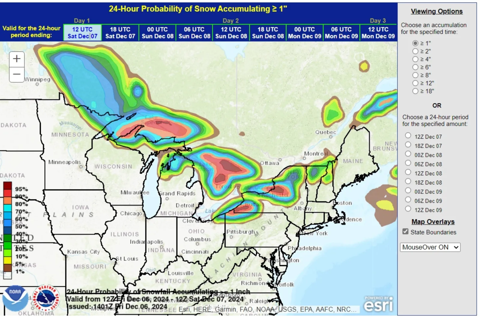
National Weather Service (NWS) Weather Prediction Center meteorologists say three states have the highest chance of seeing greater than an inch of lake effect snow this weekend, according to an updated forecast map.
Various NWS winter weather alerts remain in place across the Northeast as a potent storm finishes its wintry onslaught. Earlier this week, the storm brought strong winds, dangerous snow squalls and heavy snow across the Northeast, not even a week after heavy lake effect snow buried parts of Ohio, Pennsylvania and New York over Thanksgiving weekend.
Now, two of those states are expecting even more snow as an "intense surge of arctic air" ushers in cold temperatures on Friday.
Read More on U.S.
"The persistent flow of arctic air over the relatively warm waters of the Great Lakes has continued to bring lake-effect snows downwind into the Snow Belt," the NWS Weather Prediction Center said in its Friday morning forecast.
It continued: "By later today into tonight, another clipper currently forming along the arctic front will spread more snow across the Great Lakes from northwest to southeast. By Saturday, still another clipper will bring more widespread snowfall across the upper Great Lakes, reaching into the lower lakes Saturday night."
...
The forecast map shows the highest probability of greater than 1 inch of accumulating snowfall on Friday is in far northwestern Pennsylvania and western and northwestern New York. By Saturday, far northern Michigan joins those states with the highest probability of seeing more snow.
Lake effect snow is a common occurrence across the Great Lakes region, arriving when cold air—typically from Canada—moves across the warm waters of the lakes, prompting air to rise and form clouds that unleash several inches of snow per hour.
As much as 2 feet of additional snow could fall in parts of New York east of Lake Ontario, the forecast said.
However, heavy snow at the end of November and early December is not indicative of what's to come later this season, NWS Weather Prediction Center meteorologist David Roth told Newsweek. The Northeast is expected to fluctuate between winterlike weather and above-normal temperatures, meaning it likely won't be buried under snow until spring, despite the recent heavy snowfall.
In fact, Roth anticipates that much of the recent snow will begin melting on Sunday as a warming trend brings higher temperatures and the chance of rain.
A seasonal outlook published by the NWS Climate Prediction Center in November anticipates that temperatures from December through February will be above average across much of the Eastern U.S., including the East Coast.
The next warming trend is expected to spread widely between December 13 and 19, with much of the U.S. anticipating above-normal temperatures.
The next seasonal outlook will be published December 19.
View 0 Comments
Submit Correction
View Editorial & AI Guidelines