National Weather Service

By Anna Skinner
Associate News Editor
0
Share
Newsweek is a Trust Project member
See more of our trusted coverage when you search.Prefer Newsweek on Googleto see more of our trusted coverage when you search.
Ten states face a chance at severe thunderstorms as a cross-country storm system treks eastward this week.
The incoming storm, currently bringing snow and rain on the West Coast, will move across the United States as the week progresses. The storm will bring rain to Texas by Thursday, then expand northward to affect the Great Lakes region by the end of the week. Unsettled weather, including some locally severe thunderstorms, is expected to hit the Plains states later this week.
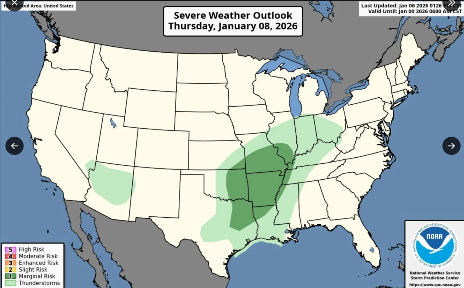
The National Weather Service (NWS) shared a map on X of areas expected to experience the strongest impacts on Tuesday.
Read More on U.S.
"Severe weather outlooks this week: Strong to locally severe storms are possible Wednesday night into Thursday morning from west-central Texas into parts of Oklahoma," the post said. "On Thursday, isolated severe storms are possible from eastern Texas and Oklahoma into parts of the Ozarks and lower/mid Mississippi Valley. Higher severe storm chances enter the forecast by Friday for portions of the lower Mississippi Valley."
...
The map showed a marginal risk, or a low-level threat, of severe storms in eastern Texas and Oklahoma, southeastern Kansas, southern Missouri, Arkansas, northwestern Louisiana, northwestern Mississippi, western Tennessee, western Kentucky and southwestern Illinois on Thursday. The risk is smaller on Friday, confined to Texas and Oklahoma.
Much of Northern Texas' precipitation has fallen as rain so far this season, with only .2 inches of snow in the Amarillo forecast region. Typically, the area sees 7.6 inches at this point in the season, NWS Amarillo meteorologist Christian Rangel told Newsweek.
NWS Amarillo warned that snow chances in its forecast region are increasing, with up to a 100 percent chance of at least 1 inch of snow in Boise City, Oklahoma, and Stratford, Texas, beginning Thursday night. Up to 5 inches is possible.
However, the precipitation will fall as rain further south.
"A fast-moving storm system will move over West Texas late Wednesday night into early Thursday morning, with high chances for a quick-hitting round of rainfall across the forecast area," NWS Lubbock said on its forecast page. "Rainfall totals will be light, with brief downpours possible. The potential for thunderstorms is low."
As of Tuesday evening, there are no NWS watches or warnings in place regarding the storm's impacts in Texas. After the system brings thunderstorms throughout the central U.S., warm air will move into the Northeast ahead of the storm, meaning mostly rain for the Northeast once the storm arrives, with some wintry weather expected in Maine.
Looking further out, northern Texas is expected to see above-average temperatures between January 11 and January 15, with below-average precipitation likely during the same period, according to the NWS Climate Prediction Center.
View 0 Comments
Submit Correction
View Editorial & AI Guidelines