...

By Anna Skinner
Associate News Editor
0
Share
Newsweek is a Trust Project member
See more of our trusted coverage when you search.Prefer Newsweek on Googleto see more of our trusted coverage when you search.
Three states are expecting significant waves, high winds, and heavy precipitation later this week as an atmospheric river pummels the Pacific Northwest.
It is the first "true" atmospheric river to strike the area this season, National Weather Service (NWS) meteorologist Joshua Wood told Newsweek, although storms sporting some atmospheric river qualities have already passed through the region.
Why It Matters
Atmospheric rivers are a "long, narrow region in the atmosphere—like rivers in the sky—that transport most of the water vapor outside of the tropics," according to the National Oceanic and Atmospheric Administration.
Read More on U.S.
The storms brought by atmospheric rivers are known for their heavy snow, heavy rain and strong winds. They more commonly affect the West Coast, particularly during the winter months. Although the storms can bring beneficial snow that helps supplement reservoirs throughout the summer dry season, they can also trigger deadly flooding, mudslides and widespread power outages
What To Know
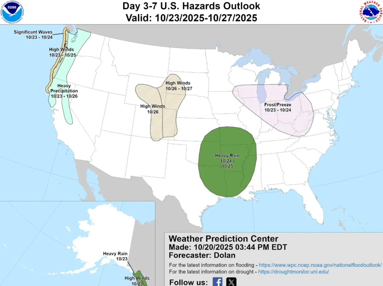
For the past week, the NWS Climate Prediction Center has warned about the incoming storm. On Monday, the NWS Weather Prediction Center shared a map showing which states would sustain the greatest impacts from the approaching storm, and when those impacts would hit.
"Here is the latest Day 3-7 Hazards Outlook valid from 10/23 through 10/27," the NWS Weather Prediction Center posted on X with a map. "A strong atmospheric river is forecast to impact the Pacific NW beginning at the end of this week and could bring heavy rain, high elevation heavy snow, as well as high winds and coastal hazards."
...
The map shows significant waves battering the Pacific Northwest coastline from Northern California through Washington state's entire coast on Thursday and Friday. High winds will mostly be felt along the entire Oregon and Washington coastlines from Thursday through Saturday. Heavy precipitation, the most widespread impact, will stretch as far south as Central California and be felt up through Western Oregon and Western Washington from Thursday through Sunday.
Precipitation will fall as heavy rain for lower elevations, whereas heavy snow is expected for higher elevations.
AccuWeather forecasts that rain will be heaviest near the coast, with up to 4 inches expected in some areas.
What People Are Saying
AccuWeather Senior Meteorologist Chad Merrill, in a forecast: “The pattern setting up along the Northwest to Northern California coast is indicative of an Atmospheric River as the moisture can be traced back to Southeast Asia. This type of a pattern typically yields heavy rain and flooding with only very high-elevation snow in the Sierra given the warm air bleeding into the storm."
Merrill added: “Atmospheric Rivers are most common from November to January in the Northwest into Northern California. They also usually dump heavy rain in a short time period; within 24 hours, several inches can trigger flooding and mudslides. The upcoming late-week and early weekend storm will likely be no exception to that rule.”
What Happens Next
The storm will bring impacts to the Pacific Northwest beginning on Thursday, with impacts persisting through the weekend for some areas. People living in the Pacific Northwest should follow the advice of local weather officials, as local NWS offices will likely begin issuing weather alerts related to the storm.
View 0 Comments
Submit Correction
View Editorial & AI Guidelines