
Spencer Platt/Getty Images/NWS


By Joe Edwards and Anna Skinner
0
Share
Newsweek is a Trust Project member
See more of our trusted coverage when you search.Prefer Newsweek on Googleto see more of our trusted coverage when you search.
Meteorologists are warning that millions of people could face dangerous heat this week as a heat dome brings several days of extreme temperatures, high humidity, and intense sunshine around the Fourth of July.
The worst of the heat is expected to peak from Tuesday through Thursday across the Midwest and Mississippi Valley before spreading into the Ohio Valley and East Coast later in the week and into the weekend, according to the National Weather Service (NWS).
“We have observed over the last 10 years or so that heat domes are becoming more intense, often breaking records in recent years,” AccuWeather chief meteorologist Jonathan Porter said. “There is growing research that points toward increased persistence of blocking patterns associated with heat domes in a warming atmosphere, which allows a hot pattern to linger for longer periods.”
Read More on Weather
The NWS said widespread major to extreme HeatRisk is likely across much of the region east of the Mississippi Valley. High temperatures in the 90s to low 100s, combined with high humidity, are expected to push heat index values to between 100 and 110 degrees, with some areas reaching as high as 115.
Energy Providers Issue Guidance as 'Ring of Fire' Expected
The extreme heat is expected to stress power grids, prompting conservation warnings from energy providers like Con Edison in New York City. Meteorologists are also warning about a "ring of fire" that could bring rounds of intense thunderstorms in addition to the extreme heat.
A heat dome can create these conditions, in which intense heat becomes trapped beneath a large area of high pressure while thunderstorms repeatedly erupt around its outer edges. The heat dome acts like a lid, suppressing cloud formation and allowing temperatures to soar beneath it.
At the same time, the boundary between the hot, stable air under the dome and cooler air outside it can become a corridor for powerful thunderstorms. These storms often track along the northern and eastern perimeter of the dome, producing rounds of damaging winds, heavy rain, hail and even tornadoes. Meteorologists call this setup a "ring of fire" because the storms appear to circle the edge of the heat dome on weather maps, much like a ring surrounding the extreme heat at its center.
"Ring of Fire Heat Dome punches above its weight with near all-time records! Here’s why… The position of this heat dome / “ring of fire” (real term) will allow winds from the west on the north side of the dome to “downslope”/ flow downhills from the Appalachians & other mountains," WFLA-TV chief meteorologist Jeff Berardelli posted on X. "This is how the I-95 cities like DC, Philly, NYC and even Boston get their hottest temperatures. That wind sinks, drys and heats, amplifying the heat! So don’t be surprised by some big numbers."
As energy demands soar, people are being asked to conserve energy where they can, such as by setting their AC to a higher temperature or turning it off while they're away.
HeatRisk: What Level 4 'Extreme' Actually Means
HeatRisk is a color-coded system that uses detailed weather, climate, and CDC health data to indicate potentially dangerous heat levels. The heat index reflects what temperatures actually feel like when humidity is factored in.
The system runs from Level 0 to Level 4, with the highest category signalling rare and prolonged extreme heat. According to the NWS Weather Prediction Center, Level 4 “Extreme” heat risk indicates conditions that can affect anyone without adequate cooling or hydration, while also straining infrastructure and healthcare systems.
“These levels of heat mean health impacts become more likely in general, and may occur in anyone without adequate hydration or cooling," the NWS said, adding that the extreme heat may persist into next week across the central and eastern U.S., with some relief possible by July 7.
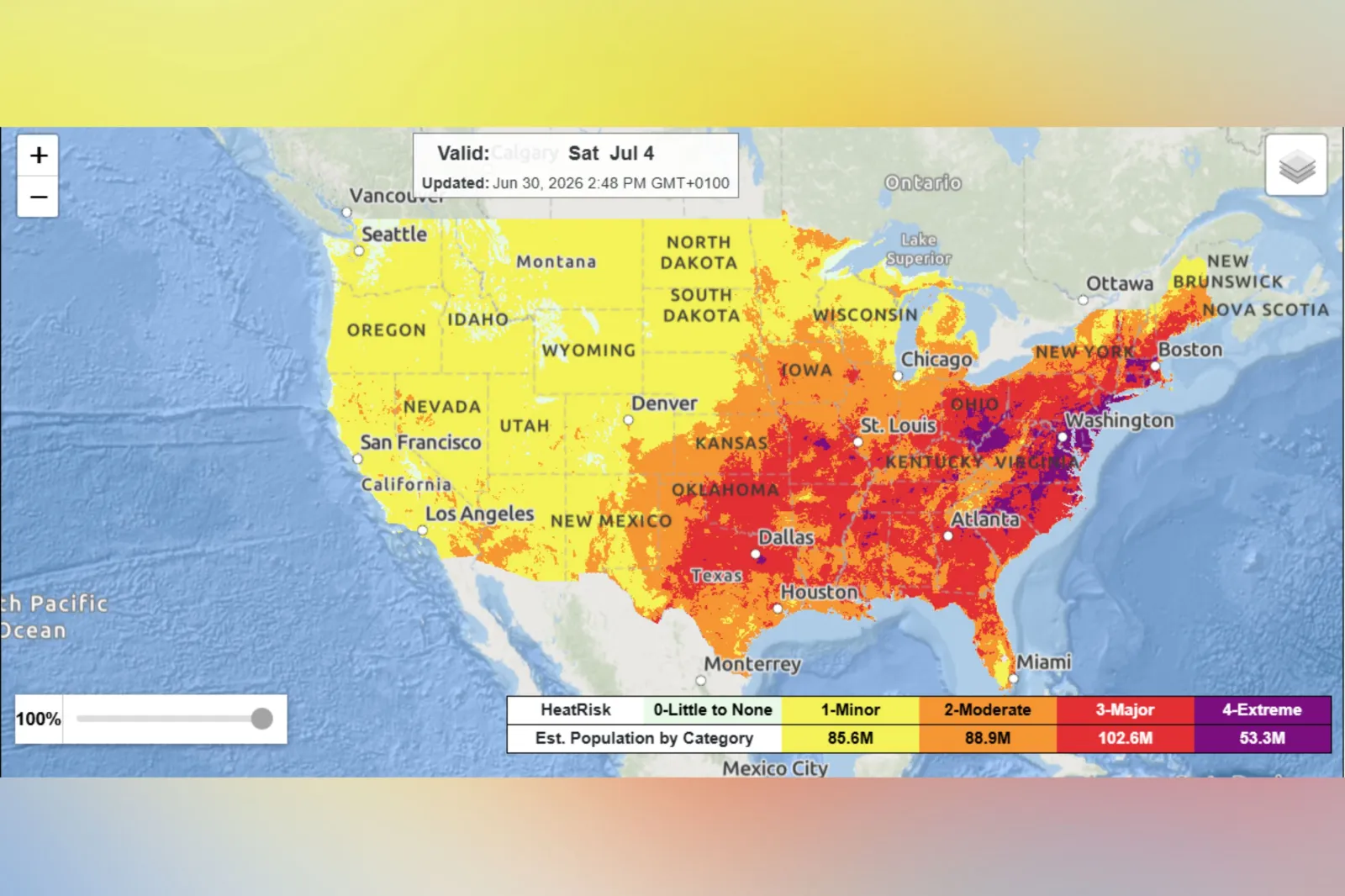
That level is forecast across wide areas—including parts of the Midwest, Ohio Valley and Northeast—from Thursday through Saturday, covering states such as Michigan, Illinois, Pennsylvania, New York, and Virginia, among others.
An NWS map indicated that areas including parts of Michigan, Wisconsin, Illinois, Indiana, Ohio, Iowa, Missouri, Tennessee, Kentucky, West Virginia, North Carolina, Virginia, Pennsylvania, and New York are expected to face Level 4 (Extreme) HeatRisk from Thursday through Saturday, July 4.
The NWS also said that dozens of record highs are expected to be broken across much of the Northeast later in the week. A separate graphic shared by the agency highlighted locations across the following states that could see records broken on Thursday, Friday, and Saturday, including:
- Maine
- Vermont
- New Hampshire
- Massachusetts
- Connecticut
- New York
- New Jersey
- Pennsylvania
- Ohio
- Michigan
- West Virginia
- Kentucky
- Rhode Island
- Maryland
- Virginia
- North Carolina
- Tennessee
Fourth of July Events Cancelled or Delayed Amid Extreme Heat
Several event organizers have already made adjustments to their holiday events because of extreme heat.
For example, in New York, the Town of Wallkill cancelled its fireworks scheduled for Thursday because of concern over extreme heat exposure for attendees.
Several municipalities in New Jersey postponed their Fourth of July celebrations, such as in Franklin Township, which moved its celebration to July 10, and the MonmouthNJ250 concert in Freehold, which was moved to July 17, according to a report by Westchester News12.
Areas Facing Most Impactful Heat on July 4
NWS data for July 4 highlights the most impactful heat (purple) concentrated across parts of the Mid‑Atlantic and central Appalachians, surrounded by widespread major heat risk (red) across much of the eastern half of the country.
...
New York Faces Record-Breaking Heat
Numerous temperature records will be broken during the multi-day heat wave, some of which are in New York.
"In New York City, a low temperature of 84 degrees is forecast on Thursday night. That would match the *average high temperature* this time of the year and be the equal-warmest night in the city in 158 years of record keeping," Washington Post meteorologist Ben Noll posted on X.
Extreme Heat Slows Transportation in Pennsylvania
In Pennsylvania, the Southeastern Pennsylvania Transportation Authority (SEPTA) is slowing its commuter rail and heavy rail systems because of extreme heat.
"We are reducing our top rail speeds by 5-10 mph due to the extreme heat. This is to help prevent damage to overhead wires, which can sag in the extreme heat, as well as to the tracks," SEPTA's chief officer of media relations Andrew Busch told Newsweek. "We expect these will be in place through the weekend. We also perform additional track inspections during periods of extreme weather."
Extreme heat can increase the risk of train derailments because steel railroad tracks expand as temperatures rise. When rails become extremely hot, the expansion can cause them to buckle or warp—a phenomenon known as a “sun kink.” These distortions can throw the track out of alignment, creating dangerous conditions for passing trains.
Heat can also cause overhead power lines to sag and place additional stress on switches and other rail infrastructure.
Because of these risks, rail operators often impose speed restrictions during heat waves, since slower-moving trains exert less force on potentially weakened track and are less likely to derail if a defect develops.
Heat Dome vs Heat Wave: What’s the Difference?
“The persistence and long-lasting nature in a particular area is the key difference between the impacts of a heat dome and a typical stretch of hot weather which might last a short duration,” Porter said in an email from the outlet sent to Newsweek on Monday. “Heat domes can prevent clouds from forming, resulting in abundant sunshine that boosts temperatures, potentially toward record levels.”
As explained by AccuWeather, the terms “heat dome” and “heat wave” are often mentioned together, but they refer to different phenomena.
A heat dome is a broad weather pattern that traps hot air over a region, sometimes for a week or longer.
In contrast, a heat wave describes a shorter-term stretch of unusually high temperatures—typically lasting three or more consecutive days—when conditions exceed a particular area’s normal heat thresholds.
As explained by AccuWeather, a heat dome functions like a lid over the atmosphere, keeping hot air confined to the same area for a prolonged stretch.
Under these conditions, cloud formation, rainfall, and thunderstorms are limited, while steady sunshine allows temperatures to rise. At the same time, the ground loses moisture more rapidly, heightening the risk of drought, and lighter winds make it easier for pollutants to accumulate—reducing air quality, especially in densely populated urban areas, per AccuWeather.
It added that heat domes have grown stronger in recent years, with many leading to record-setting temperatures.
Extreme Heat Safety Tips
The NWS urges people to take precautions during prolonged heat, warning that extreme temperatures can strain the body and lead to serious illness.
Who is most at risk:
- Young children
- Older adults
- Pregnant women
- People with underlying health conditions
Officials' recommendations:
- Stay hydrated throughout the day
- Limit time outdoors during the hottest parts of the day
- Wear lightweight, loose-fitting clothing
- Take frequent breaks in shaded or air-conditioned areas
- Check on vulnerable neighbors, relatives, and friends
- Never leave children or pets unattended in vehicles, where temperatures can rise rapidly
Heat-related illness—Warning signs to watch for:
- Dizziness
- Heavy sweating
- Nausea
- Confusion
- Weakness
Anyone experiencing severe symptoms—particularly signs of heat exhaustion or heat stroke—should seek immediate medical attention.
View 0 Comments
Submit Correction
View Editorial & AI Guidelines