AccuWeather

By Joe Edwards
Reporter
0
Share
Newsweek is a Trust Project member
See more of our trusted coverage when you search.Prefer Newsweek on Googleto see more of our trusted coverage when you search.
A developing tropical system tracking along the Texas coast could become the first named storm of the 2026 Atlantic hurricane season, but regardless of classification, forecasters warn of life-threatening flooding across the Gulf Coast and Southeast.
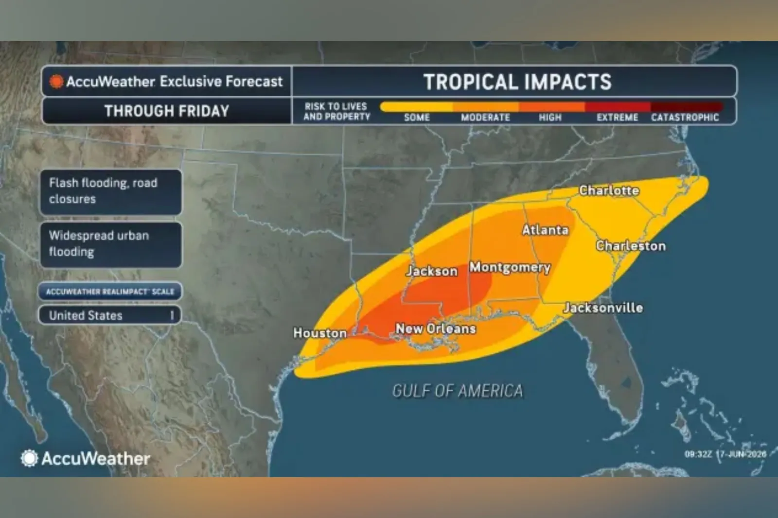
A forecast map from AccuWeather details which parts of the country face the most severe impacts as meteorologists continue to monitor a system moving along the Texas coastline with a chance of strengthening into a tropical cyclone.
The Atlantic hurricane season officially began this month and runs through November—the time frame during which the majority of tropical storms and hurricanes typically develop in the basin. Should a tropical storm form, the first name on the list for this year is Arthur.
Read More on Weather
According to AccuWeather’s map, parts of southern Louisiana, Mississippi, and southwest Alabama face the most pronounced risks to life and property through Friday. Texas, Georgia, North Carolina, South Carolina, as well as the Florida Panhandle could also see impacts, it showed.
The outlet warned that heavy rainfall could bring life-threatening flooding, damage to property, and disruptions to business and travel, regardless of how the system is officially classified.
...
In an update on Wednesday, the National Hurricane Center (NHC) said the system was moving northeast along the Middle Texas coast and was expected to cause life-threatening flash flooding across parts of the Southeastern U.S.
Flood Risk Already High Along Gulf Coast
The agency said the low-pressure area is expected to track northeast along the Texas coast on Wednesday, moving inland over southwestern Louisiana by Wednesday night.
“Some strengthening is forecast, and the disturbance could become a tropical storm today,” said the NHC.
It added: “Weakening is anticipated once the low moves inland, and it could dissipate by tonight or early Thursday.”
The agency gave a 60 percent chance of formation through 48 hours.
“The main factor limiting the development of the tropical system in the western Gulf is the short time it will be over the warm waters. The warm water is one of the main ingredients for intensification,” AccuWeather meteorologist Tom Kines told Newsweek.
“Since the time it spends over the warm water will be short lived, there is only a small window when it can become a tropical storm and that window would be this afternoon. Even if the system doesn't make it to tropical storm strength, it will still bring flooding rain, possible tornadoes and gusty winds to the Gulf Coast region.”
Kines added that the window for the system to become become Tropical Storm Arthur is closing. "It has until around 1 p.m. central time to achieve Tropical Storm status," the meteorologist said.
The NHC said the potential tropical cyclone is forecast to bring rainfall totals of 5 to 10 inches, with some isolated areas potentially seeing up to 20 inches, through early Friday.
The affected region extends from the mid and upper Texas coast east-northeast into southern and central Louisiana, Mississippi, and Alabama, as well as parts of western Georgia and the Florida Panhandle, with the NHC warning that this could bring “dangerous to life-threatening flash flooding.”
As of Wednesday morning, National Weather Service flood watches stretch from southeastern Texas across Louisiana, Mississippi, and Alabama, extending into the western Florida Panhandle and parts of Georgia.
The NHC also said that a tropical storm warning is in place for Sabine Pass to Morgan City, and that a tropical storm watch is in effect from Sargent to Sabine Pass.
This year, the National Oceanic and Atmospheric Administration has predicted a below-normal Atlantic hurricane season, forecasting a total of eight to 14 named storms.
The NHC will continue to monitor the system and will likely provide frequent updates as it develops via its website.
View 0 Comments
Submit Correction
View Editorial & AI Guidelines