...

By Anna Skinner
Associate News Editor
0
Share
Newsweek is a Trust Project member
See more of our trusted coverage when you search.Prefer Newsweek on Googleto see more of our trusted coverage when you search.
National Weather Service (NWS) meteorologists issued widespread flood watches across the Northeast and Mid-Atlantic on Wednesday as severe thunderstorms containing excessive rainfall move through the region.
"We are concerned that there will be more flooding downpours in the East coming in rounds today through Friday," AccuWeather senior meteorologist Alex Sosnowski told Newsweek. "We may continue to see this getting into the weekend and beyond."
Why It Matters
The flood risk for the East Coast comes as the nation reels in the wake of deadly flash floods that hit Central Texas over the weekend. The floods have killed at least 109 people, including 27 campers and counselors at Camp Mystic in Kerr County.
Read More on News
Flooding is the second-deadliest weather hazard in the U.S. after extreme heat. Most fatalities occur when vehicles are swept away by water.
...
What To Know
Severe storms hit the East Coast on Tuesday, prompting numerous flash flood and severe weather warnings.
The storms will continue on Wednesday. So far, flood watches have been issued for six states in the Mid-Atlantic and Northeast: Pennsylvania, New Jersey, Delaware, Maryland, Virginia and North Carolina.
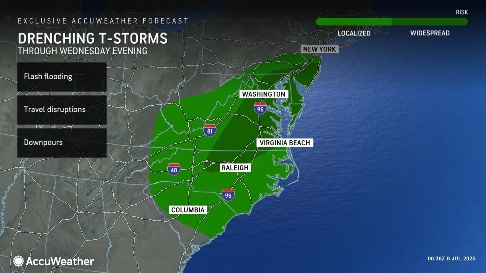
A map from AccuWeather warned that the highest-risk areas for flash flooding are Southern New Jersey, Southeastern Pennsylvania, Delaware, much of Maryland, Eastern and Central Virginia and Northern North Carolina.
Downpours associated with the storms could be severe enough to cause travel disruptions and flash floods, the map said.
Some areas remain saturated from Tropical Storm Chantal's path earlier this week, including Virginia and North Carolina. These areas are "especially vulnerable to flash flooding and stream overflows," AccuWeather reported.
The heavy rain is caused by a stalled cold front, according to a Facebook post from the NWS on Wednesday. Rain is likely to hit the drenched region again on Thursday.
The NWS included a map of the highest-risk area in its post. South-central Virginia, including Richmond, and far Northern North Carolina have the highest chance for excessive rainfall.
Sosnowski told Newsweek that a "big sweep of dry air" is needed to alleviate the rain, but with the high humidity and weak steering breezes, the region is not seeing that.
"These thunderstorms can get really tall. They are slow-moving, and they can drop a lot of rain, inches of rain per hour," Sosnowski said. "Even with the high evaporation rates we have in July, you get a pattern like this and you can't really overcome it."
What People Are Saying
NWS, on Facebook: "A stalled cold front and a second boundary will serve as a focus for potentially heavy rain across the Mid-Atlantic for today and Thursday. A broad area of a slight chance for excessive rain surrounds a more-focused area where there is a moderate chance for excessive rain mainly in Virginia.
NWS office for Blacksburg, Virginia, in a flood watch: "Excessive runoff may result in flooding of rivers, creeks, streams, and other low-lying and flood-prone locations. Creeks and streams may rise out of their banks.
"Thunderstorms with torrential rains on already saturated soils may lead to flooding this afternoon and evening."
What Happens Next
People in the flood watch areas are urged to remain on alert and follow local weather guidance, especially areas near creeks, rivers and streams.
View 0 Comments
Submit Correction
View Editorial & AI Guidelines