
AP Photo/Ethan Swope/EPA

By Anna Skinner
Associate News Editor
0
Share
Newsweek is a Trust Project member
See more of our trusted coverage when you search.Prefer Newsweek on Googleto see more of our trusted coverage when you search.
An interactive map of U.S. chemical facilities is offering a granular look at the sites where hazardous materials are used—and where accidents have been reported—at a time when high-profile incidents have raised fresh questions on risk, oversight and public awareness.
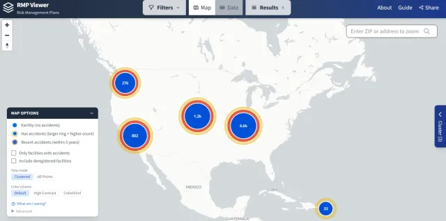
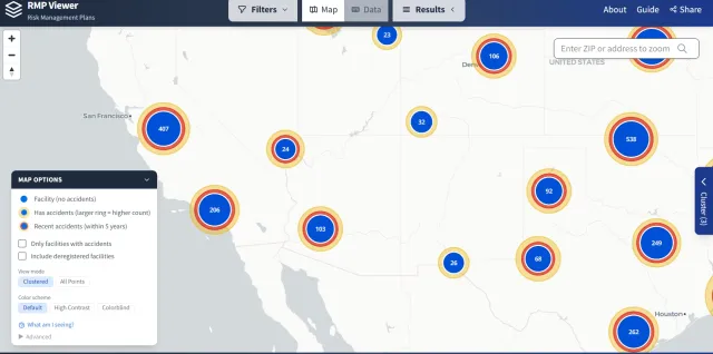
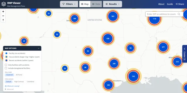
The map, available at rmpmap.org, plots thousands of facilities regulated under the Environmental Protection Agency’s (EPA) Risk Management Program (RMP), highlighting those that have reported chemical accidents alongside those that have not. Larger or darker rings indicate sites with recent incidents, drawing a visual link between industrial activity and past chemical releases across the country.
In recent days, two high-profile chemical incidents on the West Coast have underscored the real-world stakes behind federal tracking systems like the RMP database. In Garden Grove, California, a days-long emergency unfolded at the GKN Aerospace facility after a large storage tank containing methyl methacrylate, a highly flammable industrial chemical used in plastics manufacturing, overheated, prompting fears it could rupture or explode. Authorities issued sweeping evacuation orders affecting close to 50,000 residents across multiple Orange County cities as crews worked around the clock to cool the tank and relieve pressure, warning that a failure could trigger a massive explosion. Ultimately, responders managed to stabilize the tank after several days of intensive mitigation, and evacuation orders have since been lifted.
Read More on News
...
Then, a deadly industrial accident unfolded Tuesday at the Nippon Dynawave Packaging facility in Longview, Washington, when a massive chemical storage tank containing “white liquor”—a highly corrosive solution used in paper production—imploded during routine operations. The incident killed at least one worker, hurt multiple others with burns and inhalation-related injuries, and left several employees unaccounted for as emergency crews launched a complex hazardous materials response. As of Wednesday, nine people remained missing, with authorities saying there was no hope of finding survivors. On Wednesday afternoon, the U.S. Chemical Safety and Hazard Investigation Board (CSB) launched an investigation.
Together, such cases illustrate why mapping and transparency tools like the RMP map have become increasingly relevant for both communities and policymakers.
What the RMP Map Actually Shows
The tool, built using publicly available EPA data, is designed for exploration rather than real-time emergency response, allowing users to search facilities by location, chemical and accident history. The facilities mapped are not a comprehensive list of all chemical sites in the United States. Instead, they represent a specific subset of regulated sites required to submit detailed safety plans to the EPA under federal law.
This photo slideshow includes a few screenshots depicting the sites of hazardous industrial facilities, many of which have endured accidents in the last five years:
1 of 3
The Risk Management Program stems from amendments to the Clean Air Act passed in 1990. The rule was designed to prevent catastrophic chemical releases and requires facilities handling certain hazardous substances to develop and submit a Risk Management Plan to the agency.
These plans must outline:
- The potential impacts of a chemical accident
- The facility’s accident history over the past five years
- Steps taken to prevent releases
- Emergency response procedures in case of an incident
Facilities must update and resubmit these plans every five years and after significant operational changes or accidents.
A key limitation of the map is that it only includes facilities meeting specific regulatory thresholds. Under EPA rules, a site must file an RMP only if it uses or stores certain regulated chemicals above defined quantities.
These substances include roughly 140 toxic or flammable chemicals, such as chlorine, ammonia, propane and hydrogen fluoride, each with a minimum threshold that triggers reporting.
For example:
- Chlorine must be reported at 2,500 pounds
- Anhydrous ammonia at around 10,000 pounds
- Many flammable gases, like propane, at 10,000 pounds
A full list of RMP-regulated substances is visible here.
Facilities that fall below these thresholds—or that use chemicals not included on the regulated list—do not have to submit an RMP and, therefore, do not appear on the map. The Nippon site was on the map, but GKN Aerospace was not.
"GKN Aerospace (GKN) in Orange County is not subject to RMP regulations under the Clean Air Act, which is why the facility is not showing up on the map," an EPA spokesperson told Newsweek. "The facility is subject to The Clean Air Act (CAA) General Duty Clause (Section 112(r)(1)), which requires any facility that produces, processes, handles, or stores extremely hazardous substances to safely manage these chemicals, identify potential hazards, design and maintain a safe facility, and prevent or minimize accidental releases that could harm human health or the environment."
"The State of California has primary authority over regulating facilities like the one in Orange County," the spokesperson added. "With primacy, the state has the lead for many of the federal environmental and response programs."
Methyl methacrylate, the substance involved in the GKN incident, is not included on the RMP regulations list.
As a result, the RMP map is best understood as a snapshot of high-risk chemical operations, rather than a comprehensive inventory of all industrial or chemical facilities nationwide.
As recent incidents in Washington and California show, the risks associated with chemical storage and industrial processes remain a pressing concern, even outside traditional refinery hubs.
The RMP map does not predict where accidents will occur. But it does illustrate where the potential exists—and where it has already materialized—offering a clearer picture of how chemical hazards intersect with communities across the country.
View 0 Comments
Submit Correction
View Editorial & AI Guidelines