10
Loading video...

By Joe Edwards
Reporter
0
Share
Newsweek is a Trust Project member
See more of our trusted coverage when you search.Prefer Newsweek on Googleto see more of our trusted coverage when you search.
Waters around the southeastern United States could remain one of the Atlantic basin’s main areas to watch for the possible formation of tropical weather systems into early and mid-August, according to AccuWeather.
The outlet reported that, while no immediate tropical activity is expected in the Atlantic in the wake of storm Bertha last week, a broad zone near the U.S. coast may become more susceptible later in the period.
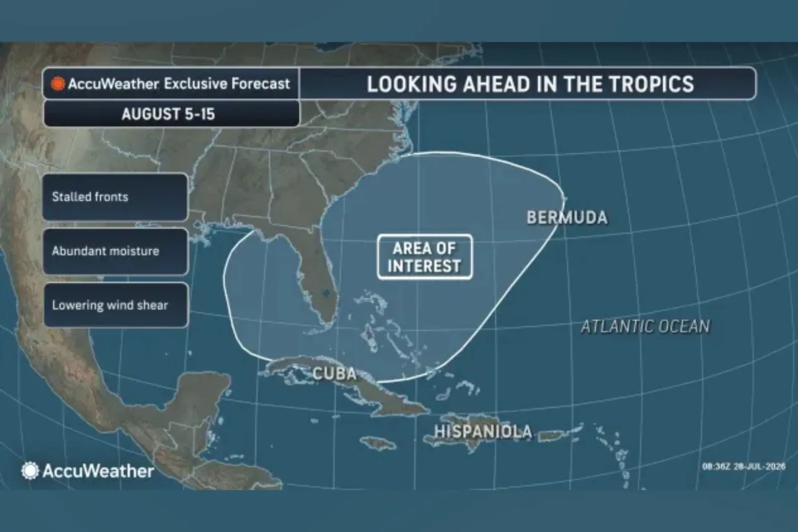
AccuWeather said the area of interest includes waters around Florida, the Carolinas, Cuba, the Bahamas and Bermuda. Forecasters there said that zone may have the best chance of producing a tropical depression or tropical rainstorm later in the first week of August and into the second week, although no activity is expected through the first few days of the month.
Read More on Weather
...
The setup is being watched because pressure in the region is expected to be somewhat lower than in surrounding areas, which AccuWeather said could help thunderstorms develop. AccuWeather Lead Hurricane Expert Alex DaSilva said fronts are expected to move into the region and gradually weaken, while waters are warm enough to support tropical activity and wind shear may ease for a time compared with earlier weeks this summer.
One possible pathway for development, according to AccuWeather, would involve a cluster of thunderstorms organizing into an area of low pressure, then separating from a decaying front. If that happened, the system could begin to acquire tropical characteristics, including a warm core and rotation, rather than behaving like a typical nontropical storm driven by temperature contrasts along a front.
The concern is not that a storm is guaranteed, but that the risk zone is close to land. DaSilva said that the area needs to be monitored because there could be "minimal notice" if a tropical storm were to form near the coast.
A storm that develops quickly near shore could bring sudden heavy rain, worsening beach conditions, coastal flooding and damaging winds, AccuWeather reported.
"From August 5-15, we will be monitoring the southwestern Atlantic and eastern Gulf, where one or two stalled fronts and lower wind shear are expected. Atmospheric conditions could become slightly more favorable for tropical development in this area," DaSilva told Newsweek, adding that this was "just an area to monitor."
"The rest of the basin currently has very hostile wind shear and dry air, as a result if anything is going to develop during the first half of August it would likely be in this area. The Caribbean will have lots of wind shear through at least the middle of August. Lots of wind shear in the Caribbean is very typical in an El Niño year."
The early-August watch area comes after Bertha became the second named storm of the 2026 Atlantic hurricane season, following Arthur. The basin has not yet produced a hurricane this season.

...
Atlantic Hurricane Season Forecasts
Looking ahead, AccuWeather said its meteorologists continue to expect a below-average to average Atlantic hurricane season. The outlet attributed that seasonal outlook to a strong El Niño, which can suppress Atlantic tropical activity.
The National Oceanic and Atmospheric Administration (NOAA) predicted a below-normal 2026 Atlantic hurricane season in its May outlook, giving a 55 percent chance of a below-normal season, a 35 percent chance of a near-normal season and a 10 percent chance of an above-normal season.
The agency forecast eight to 14 named storms, including three to six hurricanes and one to three major hurricanes, with 70 percent confidence in those ranges. NOAA said an average Atlantic season produces 14 named storms, seven hurricanes and three major hurricanes.
Hurricane Season Storm Names
The official 2026 Atlantic storm-name list, as published by the National Hurricane Center (NHC), is:
Arthur, Bertha, Cristobal, Dolly, Edouard, Fay, Gonzalo, Hanna, Isaias, Josephine, Kyle, Leah, Marco, Nana, Omar, Paulette, Rene, Sally, Teddy, Vicky and Wilfred.
As of Wednesday, the NHC says no tropical cyclone activity is expected in the Atlantic during the next seven days.
Update, 7/29/26, 12:27 p.m. ET: This article was updated with comment from Alex DaSilva.
Contact Newsweek editors for this story: Matthew Robinson and Robert Greenall
View 0 Comments
Submit Correction
View Editorial & AI Guidelines