10
Loading video...

By Anna Skinner
Associate News Editor
0
Share
Newsweek is a Trust Project member
See more of our trusted coverage when you search.Prefer Newsweek on Googleto see more of our trusted coverage when you search.
Catastrophic winds from Hurricane Melissa have started to move onshore in Jamaica, the National Hurricane Center (NHC) said on Tuesday morning, with the storm expected to soon make landfall.
"THIS IS THE LAST CHANCE TO PROTECT YOUR LIFE!" NHC posted on X just after 10 a.m. Eastern time.
Newsweek has reached out to the NHC by email for comment.
Read More on World
Why It Matters
As of Tuesday morning, Hurricane Melissa was an extremely dangerous Category 5 hurricane with maximum sustained wind speeds of 180 mph. The storm is the strongest hurricane in modern history to impact Jamaica.
The storm has killed at least seven people in the Caribbean. NHC meteorologists warned that it continues to strengthen as it approaches the island.
...
What to Know
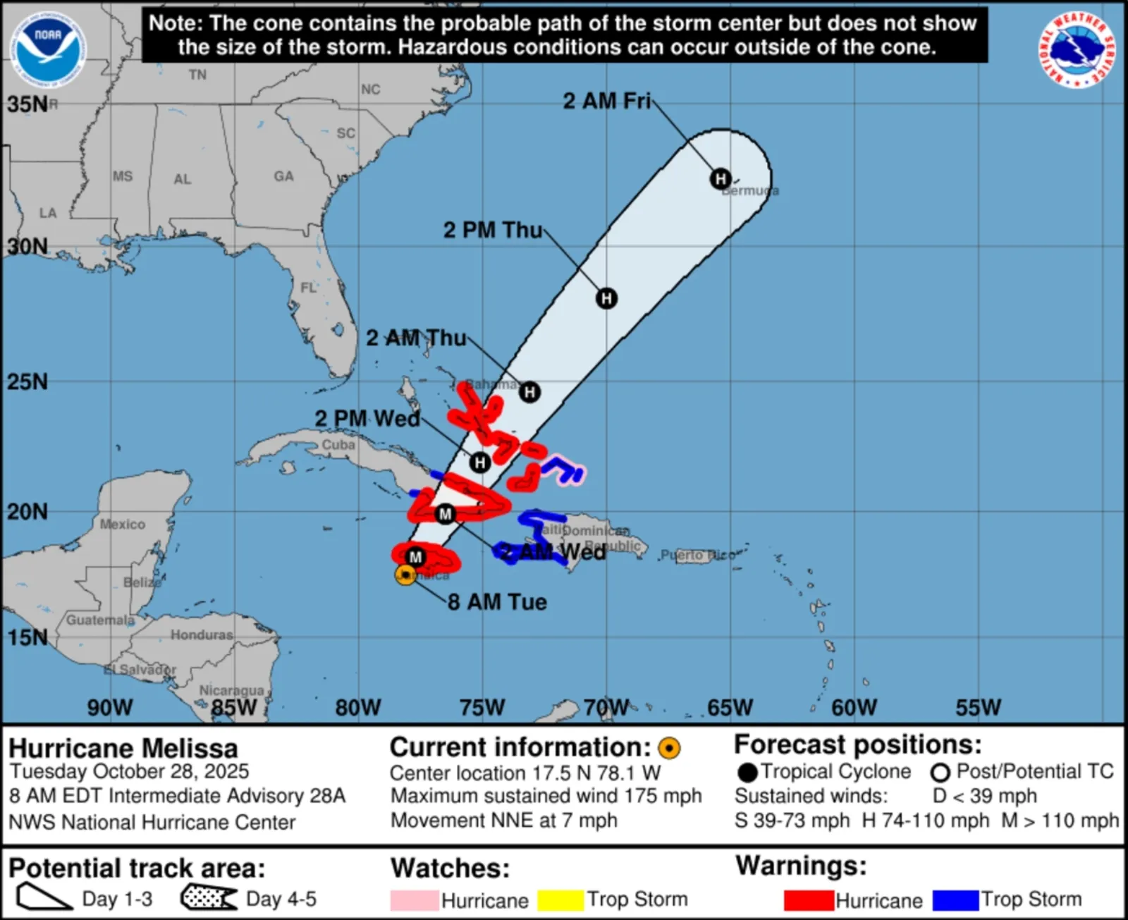
An updated forecast path for Hurricane Melissa shows the storm making landfall in southwest Jamaica as a Category 5 hurricane on Tuesday morning.
The storm will barrel through the island, accompanied by up to 30 inches of rain and devastating storm surge up to 13 feet. Winds will devastate local infrastructure.
“There is no infrastructure in the region that can withstand a Category 5,” Jamaican Prime Minister Andrew Holness said, according to The Associated Press. “The question now is the speed of recovery. That’s the challenge.”
According to the NHC forecast, the storm will then take aim at eastern Cuba, where it is expected to make landfall during the overnight hours into Wednesday morning as a major hurricane.
"Melissa is expected to reach Jamaica and southeastern Cuba as an extremely dangerous major hurricane, and it will still be at hurricane strength when it moves across the southeastern Bahamas," the NHC said in a public advisory about the storm.
The storm will retain hurricane strength after moving through the Bahamas, where it will continue through the Atlantic on Thursday. The NHC anticipates it will still be a hurricane as it tracks toward Bermuda early Friday morning.
""Melissa is moving toward the north-northeast near 7 mph (11 km/h). A turn toward the northeast with an increase in forward speed is expected later today, followed by a faster northeastward motion on Wednesday and Thursday," the NHC said in the public advisory.
"On the forecast track, the core of Melissa is expected to make landfall on Jamaica during the next several hours, move across southeastern Cuba Wednesday morning, and move across the southeastern or central Bahamas later on Wednesday."
What People Are Saying
The National Hurricane Center in a public advisory: "A life-threatening storm surge is likely along the south coast of Jamaica today. Peak storm surge heights could reach 9 to 13 feet above ground level, near and to the east of where the center of Melissa makes landfall. This storm surge will be accompanied by large and destructive waves. On the northwest coast of Jamaica, near Montego Bay, there is the possibility of 2 to 4 feet of storm surge above ground level."
AccuWeather chief meteorologist Jonathan Porter said in a report: "People in Jamaica have not experienced a direct strike from a major hurricane in nearly 40 years. Hurricane Gilbert made landfall in 1988 as a Category 3 storm, moving much faster than Melissa."
What Happens Next
Melissa will make landfall in Jamaica on Tuesday morning before tearing through the island. People there are urged to remain inside their safe shelters. People living within the warning areas in Cuba and the Bahamas should rush preparations to protect life and property to completion.
View 0 Comments
Submit Correction
View Editorial & AI Guidelines