

By Amanda Castro and Hannah Parry
0
Share
Newsweek is a Trust Project member
See more of our trusted coverage when you search.Prefer Newsweek on Googleto see more of our trusted coverage when you search.
Millions of Americans across the Midwest, Northeast and swathes of the South and Southwest were under air quality alerts Monday after smoke from multiple wildfires blanketed much of the U.S.
Smoke from the Gifford Fire, in California, has blown eastwards across Nevada, Utah and Colorado. AirNow ranked Vegas as 186 on its U.S. Air Quality Index (AQI) putting it in the "unhealthy" range.
The blaze has expanded quickly to engulf more than 100 square miles, or 65,000 acres, leaving three injured and putting more than 450 structures at risk.
Meanwhile, smoke from more than 700 active wildfires in Canada drifted across the Midwest and northwest, creating hazy skies over New York, New Jersey, Connecticut, Massachusetts, Vermont, Rhode Island, New Hampshire, Maine, Delaware, Minnesota, Wisconsin, Michigan, Indiana, Pennsylvania, and the National Weather Service said.
What To Know
- The Gifford Fire began on Friday, erupting from a number of smaller fires along State Route 166 between Santa Maria and Bakersfield.
- The National Weather Service has forecast "elevated fire weather" with hot, dry weather and wind gusts of up to 25 mph in the fire zone.
- CalFire posted on its website an evacuation order labeling the fire an "immediate threat to life," stressing that the evacuation is "a lawful order to LEAVE NOW."
- One person has already been treated for burn injuries from the blaze while two contract employees, working with firefighters, were hurt when their vehicle overturned, authorities said.
- In Arizona, the The Dragon Bravo fire has become a "megafire"—meaning it has burned 100,000 acres, or about 156 square miles, and has continued to grow to 192 square miles. As of Monday, it is only 12 percent contained.
Newsweek's live blog is closed.
Aug 04, 2025 at 06:46 PM EDT
Official warns critical fire weather slowing containment for wildfires
An official has warned that the critical fire weather is slowing containment for wildfires.
The Southwest Area Incident Management Team has been tackling another blaze, the Dragon Bravo Fire in Arizona, which has burned more than 123,000 acres and was 13 percent contained on Monday morning.
"Now, we're not seeing huge containment numbers going out because the weather is still very critical right now and so we need to ensure that those lines hold," the team's public information officer, Lisa Jennings, said.
Wind has played a particularly disruptive role, both in its intensity and behavior. Jennings explained that the unique topography of the Grand Canyon funnels wind, creating strong gusts and localized wind surges that complicate firefighting strategies and can cause rapid changes in fire behavior.
Aug 04, 2025 at 06:42 PM EDT
What does 3 percent contained mean?
The Gifford Fire has been 3 percent contained as of Monday afternoon.
When a wildfire is reported as 3 percent contained, it means that firefighters have established and secured control lines around 3 percent of the fire's perimeter—these are barriers (like trenches, roads, or natural features) expected to prevent further spread. It does not mean the fire is 3 percent extinguished or that only 3 percent of the area has burned.
The fire can still be very active and unpredictable, and the low containment indicates most of the perimeter remains uncontrolled. Containment is used to track firefighting progress and guide safety decisions like evacuations.
Aug 04, 2025 at 06:29 PM EDT
Gifford Fire live tracker map as smoke reaches Las Vegas

...
Smoke from California's Gifford fire has impacted the air quality hundreds of miles away in Las Vegas on Monday afternoon as National Weather Service (NWS) meteorologists warned of an elevated fire risk for the Southern California region through Monday.
As of Monday afternoon, the Gifford fire was over 65,000 acres in size and only 3 percent contained. The fire ignited last Friday and quickly grew to encompass thousands of acres. At least three people have been injured, and 450 structures are at risk.
Numerous zones in San Luis Obispo and Santa Barbara counties have been ordered to evacuate amid an immediate threat to life and property, according to California Department of Forestry and Fire Protection (CAL FIRE)'s webpage.
Aug 04, 2025 at 06:19 PM EDT
Gifford Fire remains just 3 percent contained, as it engulfs 65,000 acres
The Gifford Fire remains just 3 percent contained as of 6.15 p.m. ET on Monday.
More than 1,000 firefighters have been tackling the blaze, which broke out Friday and swiftly expanded to cover more than 65,000 acres.
Gifford is not the only blaze spreading across California.
The Lake Fire, which erupted Sunday, has engulfed around 400 acres and is now 40 percent contained.
The Gold Fire, in San Bernardino, broke out Monday and has spread to 348 acres. It is 0 percent contained.
Aug 04, 2025 at 05:51 PM EDT
Smoke begins to lift over Maine
Smoke is beginning to clear above Maine, according to the National Weather Service (NWS).
The NWS said that a cold front moving southwards through the state was helping to clear out some of the haze that had settled over the state, thanks to the Canadian wildfires.
"Still very smoke[y] from the Central Highlands south to the Downeast Coast. #MEwx #Maine," the service added on X,
Aug 04, 2025 at 05:41 PM EDT
NWS forecast shows southwesterly wind carrying Gifford Fire smoke across California
A new animation from the National Weather Service shows a strong southwesterly wind carrying Gifford Fire smoke across California over the next few days.
The service shared footage of the smoke flowing across central California including to Kern County.
Aug 04, 2025 at 05:24 PM EDT
Map shows air quality alerts across US amid multiple wildfires

...
Aug 04, 2025 at 05:01 PM EDT
The latest evacuation map for Gifford Fire

...
Aug 04, 2025 at 04:54 PM EDT
Wildfire smoke hangs in Seattle: What to know
Wildfire smoke continues to affect the Seattle area, primarily from the Bear Gulch Fire in Olympic National Park and additional haze from Canadian wildfires.
The smoke has led to hazy skies and moderate air quality levels across much of the Puget Sound region. While most of the smoke remains aloft, occasional ground-level impacts are being reported, especially in communities downwind such as Kitsap and Island Counties. The Washington Smoke Blog and Puget Sound Clean Air Agency expect these conditions to persist through midweek, with onshore winds likely improving air quality by Thursday or Friday.
The primary health concern is fine particulate matter which can cause respiratory issues, particularly for sensitive groups like children, the elderly, and those with asthma or heart conditions.
Even healthy individuals may experience symptoms such as coughing and throat irritation with prolonged exposure. Health officials recommend staying indoors during smoky periods, using air purifiers or air conditioning in recirculate mode, and avoiding strenuous outdoor activities. When outdoors, properly fitted N95 or P100 masks are the most effective for smoke protection.
Aug 04, 2025 at 04:31 PM EDT
Wildfire smoke in Maine: What to Know
A haze has settled over Maine as wildfire smoke from Canada drifts over the sate causing poor air quality.
More than 700 active wildfires in Canada—particularly in Saskatchewan, Manitoba, and Alberta—has drifted across much of the Midwest, Great Lakes, Northeast, and Southwest.
A high-pressure system is trapping smoke over the northeast region, preventing it from dispersing.
On Sunday, Maine's Department of Environmental Protection issued an Air Quality Alert from 1 AM to 11 PM for much of the state—specifically for Western and Eastern Interior regions including Franklin, Somerset, York, Cumberland, Androscoggin, and Kennebec counties—due to particle pollution reaching levels considered "Unhealthy for Sensitive Groups."
Aug 04, 2025 at 03:59 PM EDT
Understanding the air quality index and its impact on health
The Air Quality Index (AQI) is a vital tool designed to help the public interpret local air pollution levels and their potential health effects, per AirNow. To simplify this information, the AQI is divided into six color-coded categories, each representing a different level of concern.
- Good (0–50, Green): Air quality is excellent and poses little or no health risk.
- Moderate (51–100, Yellow): Generally acceptable, though some individuals, unusually sensitive to pollution, may experience mild symptoms.
- Unhealthy for Sensitive Groups (101–150, Orange): People with lung or heart conditions, children, older adults, and those active outdoors may be affected.
- Unhealthy (151–200, Red): Health effects may begin to impact the general population, with sensitive groups at greater risk.
- Very Unhealthy (201–300, Purple): A health alert is issued; everyone may experience more serious effects.
- Hazardous (301–500, Maroon): Emergency conditions; the entire population is likely to be affected.
Aug 04, 2025 at 03:46 PM EDT
Hazy skies blanket NYC as Canadian wildfire smoke returns
New York City woke to a familiar gray haze on Monday as smoke from Canadian wildfires once again drifted south, prompting an air quality alert across all five boroughs. The National Weather Service issued warnings for the entire state and much of New England, with conditions deemed unhealthy for sensitive groups until midnight.
The smoke, primarily from out-of-control fires in Manitoba, has become a seasonal intruder, carried by prevailing wind patterns. NYC Emergency Management advised residents to limit outdoor activity, close windows, and use air purifiers. Those with heart or lung conditions, children, and older adults were urged to take extra precautions.
This marks the third consecutive summer New Yorkers have faced deteriorating air quality due to Canadian wildfires. The most severe episode occurred in June 2023, when thick smoke turned the skyline an eerie orange. Monday's haze, while less dramatic, still obscured visibility and left a faint scent of smoke lingering in the air.
Similar alerts were issued across the Northeast, affecting states from Maine to Delaware. Forecasters expect conditions to improve by Tuesday, but the recurring nature of these events has left many wondering if smoky summers are here to stay.
Aug 04, 2025 at 03:29 PM EDT
Canadian wildfires fuel smoke drift into northern U.S.
Out-of-control wildfires burning across Canada's Northwest Territories, Alberta, Saskatchewan, Manitoba, and western Ontario are sending thick plumes of smoke into the northern United States this week. The smoke is riding a cooler air mass that recently shifted south from central and northern Canada, blanketing parts of the Midwest and Northeast in haze.
Extreme drought conditions have turned vast stretches of land into tinderboxes, contributing to over 16.3 million acres burned so far in 2025, marking the third-highest total on record. According to the Canadian Interagency Forest Fire Center, 247 large wildfires are active nationwide, with 165 currently out of control. Saskatchewan and Manitoba are experiencing the most severe outbreaks, with 53 and 47 major fires, respectively.
While rainfall has been scarce in the hardest-hit regions, forecasters say storms later this week could bring some relief to the Canadian Prairies, potentially aiding containment efforts and improving air quality across the border.
Aug 04, 2025 at 03:16 PM EDT
Incredible footage shows smoke billowing dozens of feet into the sky from wildfire
Aug 04, 2025 at 03:10 PM EDT
Canadian wildfire smoke to reach Western Europe via jet stream
Wildfire smoke from the Canadian Prairies is set to travel over 5,000 miles across the Atlantic this week, carried by a powerful jet stream. While the smoke will remain high in the atmosphere and won't impact surface air quality, it's expected to create vivid sunrises and sunsets across parts of Western Europe, including Ireland, Norway, and Germany, from Tuesday through Thursday.
This transatlantic journey marks the second time this year that Canadian wildfire smoke has reached distant regions. In early June, similar plumes made their way to Russia, underscoring the global reach of North America's record-breaking fire season. Scientists note that while elevated smoke poses minimal health risks, its visual effects can be striking, especially during twilight hours.
Aug 04, 2025 at 03:10 PM EDT
Wildfire smoke triggers ‘unhealthy’ Las Vegas air quality
Smoke blowing over Las Vegas from the California wildfires has created a hazy sky and poor air quality over Sin City Monday.
An Air Quality alert from AirNow ranks Vegas as 186 on its U.S. Air Quality Index (AQI), a color-coded scale from 0 to 500 used to communicate air quality. That puts the city in the "unhealthy" range.
A representative from Clark County Department of Environment & Sustainability told the Las Vegas Review Journal that the wildfires will likely affect air quality throughout the week.
AirNow warns that sensitive groups such as people with lung disease, children and teens, older adults, and people who are routinely active outdoors for six or more hours a day, should choose less strenuous activities and reduce the amount of time you are active outdoors on Monday.

...
Aug 04, 2025 at 03:01 PM EDT
At least three people have been injured in the Gifford Fire
At least three people have been hurt in the Gifford Fire as firefighters battle to contain the blaze which has spread across more than 65,000 acres.
One person has already been treated for burn injuries from the California wildfire, while two contract employees, working with firefighters, were hurt when their vehicle overturned, authorities said.
Aug 04, 2025 at 02:51 PM EDT
Wildfire smoke blankets large swaths of U.S. as fires intensify
The Midwest, Great Lakes, Northeast, and Southwest are facing some of the heaviest concentrations of wildfire smoke in the country this week, with hazy skies and poor air quality stretching from eastern Iowa to Maine. Cities including Chicago, Detroit, Buffalo, and Green Bay are already experiencing near-ground smoke, while Toronto, Ottawa, and Montreal are also affected.
As the smoke drifts southward, Boston, New York, and Philadelphia are expected to see increased haze, though surface concentrations in the Mid-Atlantic will likely remain low. Forecasts suggest smoke will linger across much of the Northeast through Friday, trapped by high-pressure systems.
Out west, the White Sage Fire in Arizona and Monroe Canyon Fire in Utah—each burning over 55,000 acres—are sending smoke eastward into Colorado, southern Wyoming, and northern New Mexico. Southern California is also seeing expanded smoke coverage, with 16 active fires statewide. The Gifford Fire, now the largest in California, has triggered mandatory evacuations in San Luis Obispo and Santa Barbara counties.
Strong winds and record-breaking heat are expected to elevate wildfire risks across several Western states, complicating containment efforts and worsening air quality.
Aug 04, 2025 at 02:50 PM EDT
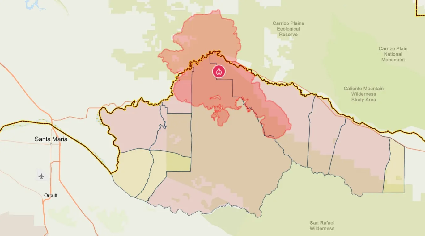
Evacuation zone map for California wildfires: Evacuation orders, warnings issued around Gifford Fire
...
A new map reveals the evacuation zones around the Gifford Fire, to the east of Santa Maria, California.
Around 300 square miles is currently under either an evacuation order or warning.
All residents in evacuation order zones are urged to "leave now."
"Immediate threat to life. This is a lawful order to leave now. The area is lawfully closed to public access," the order reads.
The areas highlighted in yellow on the map are under evacuation warnings, meaning residents must "be ready to leave at a moment's notice."
Aug 04, 2025 at 02:36 PM EDT
North American cities rank among world’s most polluted on August 4
Several major cities in North America recorded some of the worst air quality globally on August 4, according to IQAir, as reported by The Washington Post. Toronto and Detroit ranked second and fifth respectively, with air quality index (AQI) values of 158 and 147—levels considered unhealthy for sensitive groups. Montreal and Chicago also made the top ten, highlighting the widespread impact of wildfire smoke and urban pollution across the continent.
Kinshasa, Democratic Republic of the Congo, topped the list with an AQI of 170, followed by Manama, Kampala, and Cairo. Experts attribute North America's poor air quality to ongoing Canadian wildfires, which have sent smoke drifting into the U.S. and parts of Canada, triggering health advisories and visibility concerns.
Health officials recommend limiting outdoor activity, especially for vulnerable populations, and using air filtration indoors to reduce exposure. With over 700 wildfires still active in Canada, conditions may remain hazardous in the coming days.
Aug 04, 2025 at 02:36 PM EDT
New maps show spread of Gifford Fire as blaze engulfs more than 65,000 acres in California

...

...
Aug 04, 2025 at 02:23 PM EDT
Gifford fire grows to 65,000 acres, triggers new evacuation warnings
The Gifford Fire burning in southeast San Luis Obispo County surged over the weekend, prompting expanded evacuation warnings and orders by Monday morning. As of 9 a.m., the blaze had scorched 65,062 acres and remained just 3% contained, according to Los Padres National Forest officials. Crews are battling the fire under hot, dry conditions that are expected to persist through the week, raising concerns about increased fire activity.
The fire, which ignited Friday near Highway 166, has spread rapidly across rugged terrain and into the Los Padres National Forest, west of the Madre Fire burn scar. Highway 166 remains closed, and a planned closure of Highway 41 was canceled due to the fire's proximity. Three injuries have been reported, and more than 20 zones across San Luis Obispo and Santa Barbara counties are under evacuation orders or warnings.
Firefighters made overnight progress constructing containment lines along the northern edge, linking efforts with the Madre Fire perimeter. Crews are also working to protect structures in Schoolhouse and Cottonwood Canyons. A temporary evacuation shelter remains open at Benjamin Foxen Elementary School in Santa Maria, with American Red Cross staff on site to assist displaced residents.
Officials warn that the fire could intensify Monday afternoon as temperatures climb into the 90s and humidity drops. A warming trend is expected to continue through the weekend, complicating containment efforts.
View 0 Comments
Submit Correction
View Editorial & AI Guidelines