Newsweek/map thumbnail

By Joe Edwards
Reporter
0
Share
Newsweek is a Trust Project member
See more of our trusted coverage when you search.Prefer Newsweek on Googleto see more of our trusted coverage when you search.
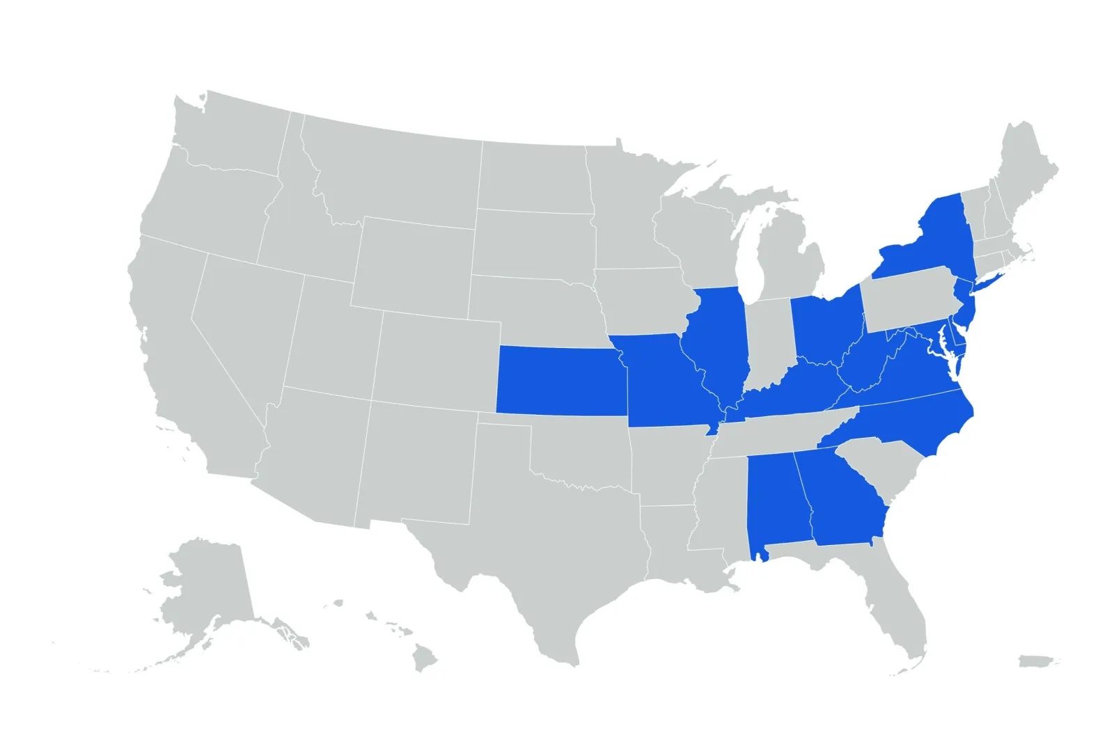
A widespread freeze warning from the National Weather Service (NWS) has been issued to alert millions of residents across 15 states that temperatures are set to drop below freezing.
Why It Matters
The warning raises concerns for agricultural operations and early-spring vegetation, which could face significant damage.
Read More on News
Vulnerable populations, including infants and older adults, are susceptible to health risks because of the colder temperatures.
What To Know
According to the NWS, freeze warnings were in effect across large portions of the Midwest, East and South, including parts of Alabama, Kansas, Missouri, Illinois, Indiana, Kentucky, Ohio, West Virginia, Virginia, Maryland, Delaware, North Carolina, New Jersey, New York, and Georgia.
Temperatures were forecast to dip into the mid-20s overnight in some places, in a widespread cold snap.
The warnings, in place through Tuesday morning in most cases but through Wednesday morning in some, specifically warn of sub-freezing temperatures that could kill crops and other sensitive vegetation. Residents are urged to take precautionary measures, such as covering outdoor plants and ensuring animals have warm shelter.
For agricultural operations facing sub-zero temperatures, the United States Department of Agriculture (USDA) advises focusing on crop protection, livestock care, and preparedness measures to mitigate risks.
The USDA also advises everyone to ensure that necessary equipment, such as generators and heaters, are in good working order.
Residents in the affected areas should monitor local forecasts for updates and consider protecting frost-sensitive flowers and vegetables.
The freeze warnings are expected to expire by mid-morning Wednesday at the latest, as daytime temperatures rebound. However, a second, weaker front could bring near-freezing temperatures later in the week.
What People Are Saying
Meteorologist Jeff Nordeen told Newsweek: "The cold air was brought in by very broad high pressure off of the West Coast that brought colder air from Canada into the Northeast, Midwest and as far south as the Southeast.
"Today and tomorrow the cold nights will still hold on for Upper Midwest, Ohio River Valley and mid-Atlantic to the Northeast states before temperatures trend warmer ahead of the storm late week."
The NWS Weather Prediction Center said on X on Monday: "Cold temperatures, near or below freezing, on Tuesday and Wednesday mornings will be felt across areas that were impacted by the recent multi-day storms. Cold weather precautions should be taken, especially for sensitive individuals or for recovery operations."
NWS Springfield, Missouri said on X, Monday: "Chilly overnight temperatures are expected again tonight. A Freeze Warning is in effect for the entire area from 11 PM tonight night into 9 AM Tuesday. Protect sensitive vegetation!"
NWS Raleigh, North Carolina said on X, Monday: "Steady rain will end from west to east overnight. A cold front will clear through central NC bringing cooler temperatures Tuesday and Tuesday night. A Freeze Watch has been issued for much of central NC for Tuesday night into Wednesday morning."
What Happens Next
The NWS will continue to issue updates and warnings as conditions evolve.
Residents in affected areas are advised to check their local NWS office's website for the latest information and forecasts.
Update, 4/10/2025, 07:58 a.m. ET: This article was updated with comment from Jeff Nordeen.
View 0 Comments
Submit Correction
View Editorial & AI Guidelines