...

By Joe Edwards
Reporter
0
Share
Newsweek is a Trust Project member
See more of our trusted coverage when you search.Prefer Newsweek on Googleto see more of our trusted coverage when you search.
A recent forecast suggests Florida and surrounding areas could see impacts from tropical cyclones in the coming weeks.
Why It Matters
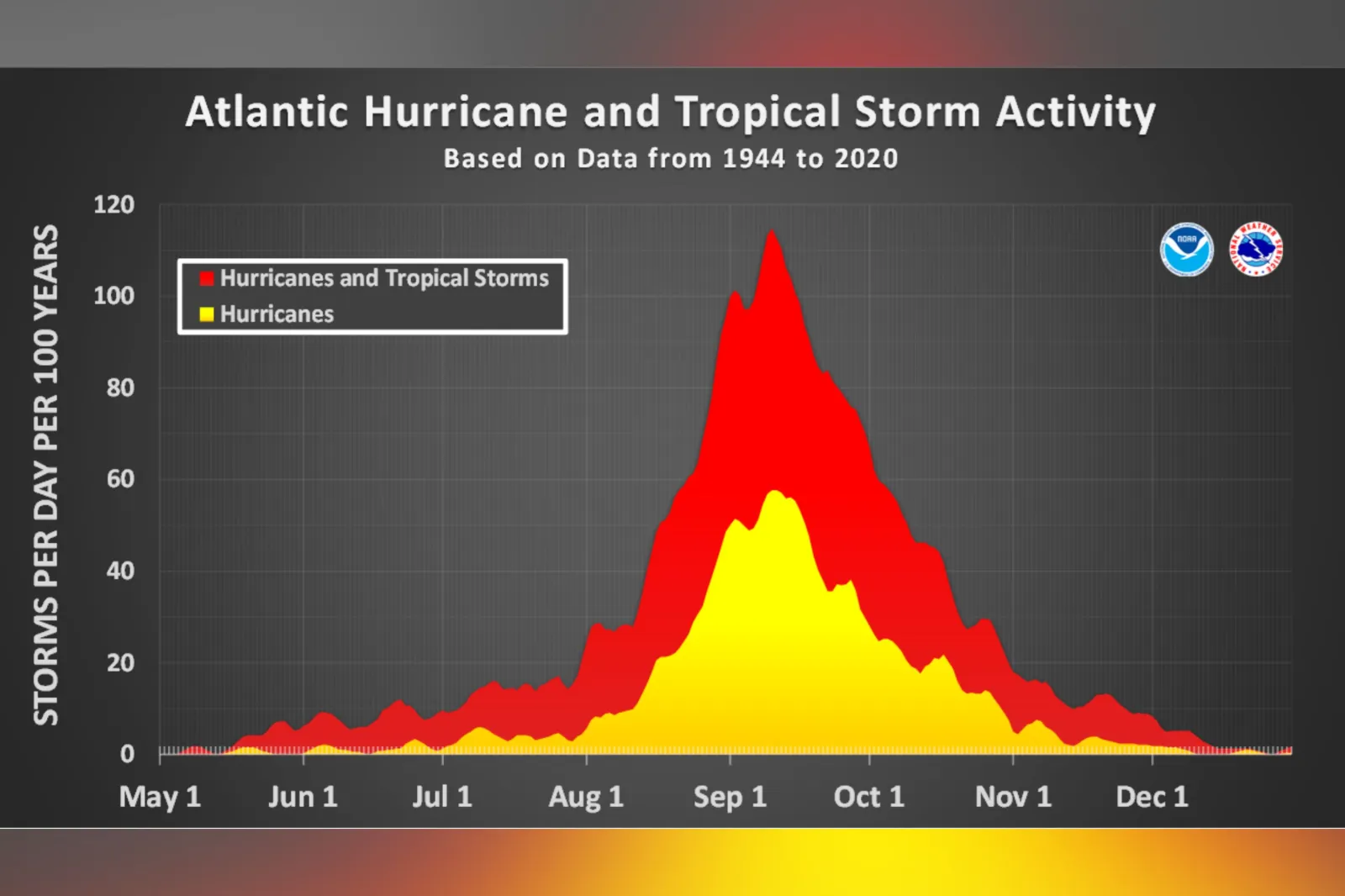
According to the National Hurricane Center (NHC), the peak of the Atlantic hurricane season is September 10, with most activity occurring between mid-August and mid-October.
Read More on News
What To Know
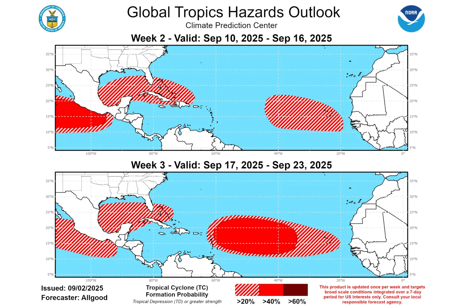
In its latest global tropics hazards outlook, covering September 10-16 and September 17-23, the Climate Prediction Center (CPC) indicated at least a 20 percent chance of cyclone formation, at least of tropical depression strength, in the Florida, Gulf, and Caribbean region.
...
"We are approaching the peak of the Atlantic hurricane season, and this outlook highlights a potential for tropical cyclone formation in the vicinity of Florida," NWS meteorologist Adam Allgood told Newsweek.
"While it is too early to determine the specific timing or track of any storm that develops, Florida residents should review their hurricane plans as needed and monitor guidance from the National Hurricane Center, their local NWS forecast office, and local governmental authorities should a system develop."
The NHC defines a cyclone as "a rotating, organized system of clouds and thunderstorms that originates over tropical or subtropical waters and has a closed low-level circulation."
They are categorized by wind speed: tropical depressions have maximum sustained winds of 38 mph or less; tropical storms range from 39 to 73 mph; and hurricanes reach 74 mph or higher, according to the agency.
As of Thursday, the NHC was monitoring a disturbance in the Atlantic with an 80 percent chance of cyclone formation over the next seven days.
"Environmental conditions are conducive for development of this system during the next several days, and a tropical depression is likely to form late this week or this weekend over the eastern or central tropical Atlantic while moving slowly toward the west-northwest at 5 to 10 mph," the agency said in an early-morning update.
Meanwhile in the Pacific, the NHC continued to track Hurricanes Kiko and Lorena.
Lorena is expected to bring heavy rainfall to Baja California Sur and Sonora Mexico in Mexico through Friday, increasing the risk of flash floods and mudslides across northwest parts of the country.
Kiko—a Category 4 hurricane at the time of writing—has the potential to make a rare landfall in Hawaii, according to AccuWeather.
...
What People Are Saying
NWS meteorologist Adam Allgood told Newsweek: "We analyze the state of the global tropics and consider the influence of various climate and weather scale features that can cause an area to become more favorable or less favorable for tropical cyclone formation. Often these features maintain some predictability into Weeks 2 and 3. This information is combined with guidance from multiple weather models to produce the global tropics hazards outlook."
Meteorologist Paul Dellegatto said in a post on X, Tuesday: "We are in the peak of the hurricane season, so it is not unusual to be watching a strong tropical wave in the eastern Atlantic.
"Conditions look favorable for development, and by this weekend, we should have a named storm (Gabrielle) to track."
Weather page Florida Tropics posted on X, Tuesday: "New global tropics hazards outlook has Florida surrounded starting September 10. Typical areas for development as we enter peak season."
What Happens Next
The CPC says its global tropics hazards outlook is every Tuesday.
Atlantic hurricane season runs through November 30. Forecast updates are issued regularly by the NHC on its website and social media channels.
Update 09/05/2025, 11:26 a.m. ET: This article was updated with comment from Adam Allgood.
View 0 Comments
Submit Correction
View Editorial & AI Guidelines