...


By Micah McCartney and John Feng
0
Share
Newsweek is a Trust Project member
See more of our trusted coverage when you search.Prefer Newsweek on Googleto see more of our trusted coverage when you search.
The USS Tripoli has been spotted making a brief port call as it raced toward the Middle East to join the U.S.-Israeli war against Iran.
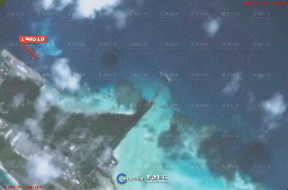
On Monday, the 844-foot warship was docked at the remote island of Diego Garcia in the Indian Ocean, according to satellite imagery shared by MizarVision, an AI startup in Hangzhou, China, that specializes in geospatial intelligence.
MizarVision has been publishing high-resolution images of American bases, warships and other military assets since the U.S. and Israel launched their war against Iran on February 28. In its post on Weibo, MizarVision said the images were taken by a "startup company's satellite" during a pass over the Indian Ocean at 11:46 a.m. Beijing time on Monday. It may be one of the last sightings of the Tripoli before it arrives in the Middle East later this week.
Read More on World
"Given no sign of a fleet oiler, this is a logical stop to top off fuel and stores before making the final push into @CENTCOM," open-source intelligence analyst MT Anderson wrote on X, referring to the U.S. Central Command. Anderson also shared a similar photo of the Tripoli at the Diego Garcia pier.
Forces Redirected From East Asia
Diego Garcia is a joint U.S.-U.K. base located 450 miles south of the Maldives. In addition to naval facilities, the island's 12,000-foot runway has supported bombing runs against Iran in the current conflict and the Yemen-based Houthis from 2024 to 2025. Tehran fired ballistic missiles toward the base in an unsuccessful attack on the hub, British officials said last week.
The Tripoli redeployed from the South China Sea last week, with satellites showing the flattop sailing southwest at high speed while under escort by at least two destroyers. The composition and location of the rest of the Tripoli's task force are unknown.
...
Another Japan-based ship, the amphibious transport dock USS San Diego, is likely not far behind, according to Anderson's analysis of satellite imagery that appears to show the vessel clearing the Strait of Malacca on its way to the Middle East.
Newsweek has contacted the U.S. Seventh Fleet for comment by email.
The U.S. is now surging forces into the region as the conflict drags on, though President Donald Trump previously said Operation Epic Fury could last as few as "four to five weeks."
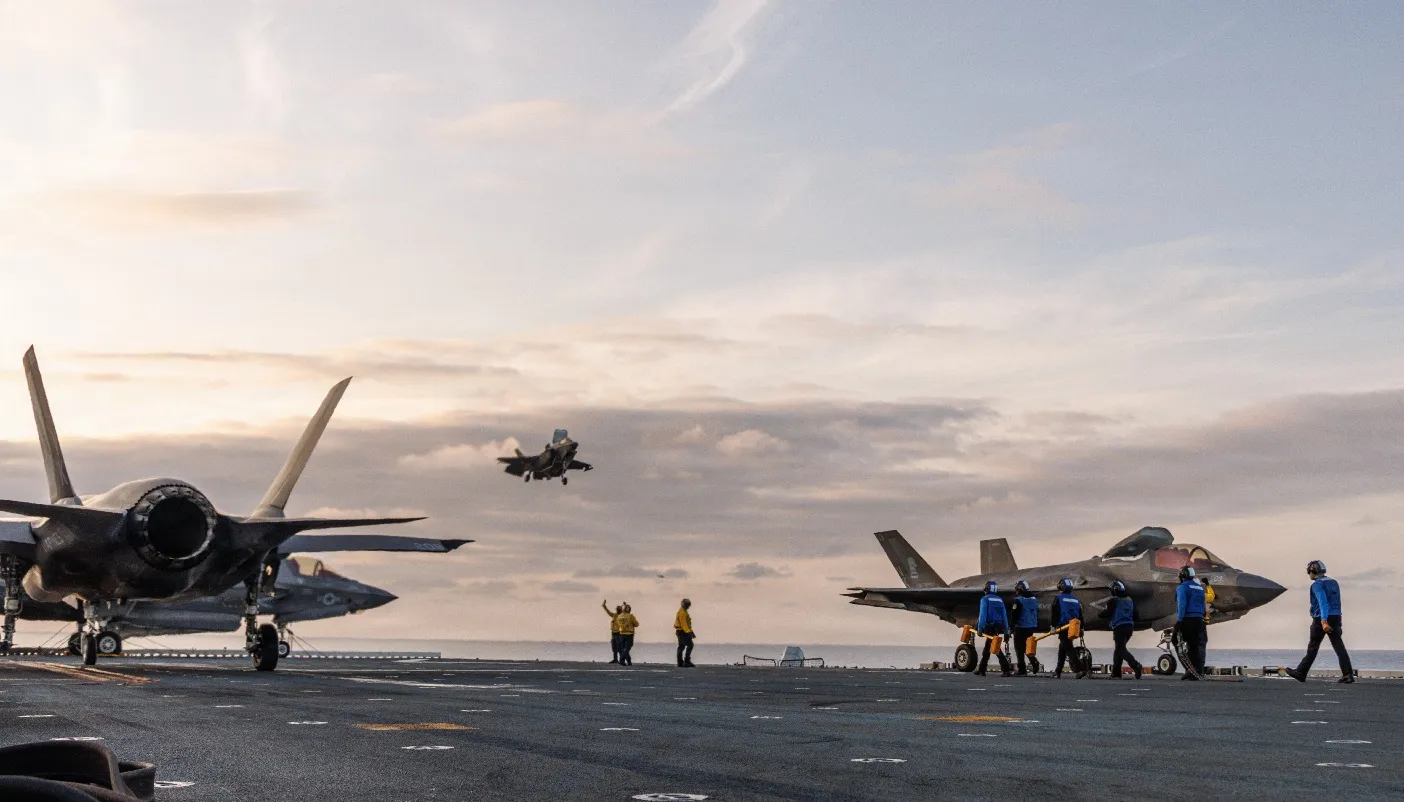
The Tripoli alone is ferrying more than 2,000 Marines. Its complement of F‑35B Lightning IIs—the short takeoff and vertical landing variant of the Lockheed Martin-built stealth fighter—is set to augment U.S. firepower in the region.
Yet this comes at the expense of a weakened force posture in the Asia-Pacific. In addition to the warships, the Pentagon has been pulling its THAAD missile shield from South Korea as Iranian counterattacks deplete American and Israeli stocks of missile interceptors.
The Tripoli will enter the Central Command area of operations on Friday, The Wall Street Journal reported, citing U.S. officials.
Satellite Imagery During Wartime
Although not without its drawbacks, including the risk of manipulation, satellite imagery has become a game changer for open-source intelligence (OSINT) researchers hoping to monitor conflicts and track damage or mass-casualty events.
MizarVision did not say which startup provided the satellite image in which its AI-powered tool identified the vessel assumed to be the Tripoli, but it was a rare glimpse into the latest U.S. military maneuvers linked to the Iran war amid a U.S. provider blackout.

...
Before the U.S. and Israel began their bombing campaign against Iran on February 28, Earth-imaging firms in the U.S. were already cautious about their product for fear of giving too much away.
Vantor, a leading provider, told Newsweek it does not supply the media with high-resolution pictures of U.S. military deployments. And in the first week of the conflict, Planet Labs, another large imaging company, said it would voluntarily delay its release of imagery over U.S. and NATO sites to avoid aiding adversary forces.
None cited any pressure from the U.S. Defense Department, which told Newsweek it did not have any comment on the decision taken by private companies.
Luke Fischer, the CEO of SkyFi, a spatial intelligence company in Austin, Texas, told Newsweek: "During active conflict, it's standard practice for commercial satellite companies to restrict or delay public access to imagery over certain areas of interest."
"First, the priority during active military operations is getting the right data to the right people. National security practitioners, allied governments, and operational decision-makers need access to this imagery in real time or near-real time, and the distribution pipeline reflects that," he said.
"Second, there's a real concern about bad actors using commercially available imagery to gain operational intelligence during a live conflict. The same data that an analyst at a think tank might use to write a report could, in the wrong hands, be used to refine targeting or assess damage in ways that put people at risk. Providers take that seriously," Fischer continued.
...
The Copernicus Browser, the European Space Agency website that supplies low-resolution Earth imagery from its fleet of Sentinel satellites, has been a popular alternative despite the technical limitations. Meanwhile, the Pentagon's own Defense Visual Information Distribution Service typically releases official photographs with a standard delay of days to weeks.
"The real-time accessibility of commercial satellite imagery has always been the most critical element of OSINT work. Given that contemporary military superpowers like the U.S. and China possess their own sovereign or high-end private real-time imaging capabilities, the impact of this delay falls primarily on nations lacking such infrastructure—such as Iran—and on civilian observers," said analyst Joseph Wen, who as a student mapped all known Chinese military bases and facilities online and then wrote a book on how to do it.
"A 14-day window provides ample time for military units to redeploy, evacuate, or implement camouflage. Therefore, this delay ensures that commercial imagery does not inadvertently serve as a real-time reconnaissance tool for Iran or its proxies," Wen, who also co-founded the Taiwan Defense Studies Initiative, told Newsweek.
He added, "While this may not be a mandatory government order, commercial firms often take such initiatives to align with their home country's national security interests, preventing their technology from being weaponized against U.S. and allied operations in the Middle East."
In a polarized era, the center is dismissed as bland. At Newsweek, ours is different: The Courageous Center—it's not "both sides," it's sharp, challenging and alive with ideas. We follow facts, not factions. If that sounds like the kind of journalism you want to see thrive, we need you.
When you become a Newsweek Member, you support a mission to keep the center strong and vibrant. Members enjoy: Ad-free browsing, exclusive content and editor conversations. Help keep the center courageous. Join today.


View 0 Comments
Submit Correction
View Editorial & AI Guidelines