
...

By Anna Skinner
Associate News Editor
0
Share
Newsweek is a Trust Project member
See more of our trusted coverage when you search.Prefer Newsweek on Googleto see more of our trusted coverage when you search.
A new weather briefing from the National Weather Service (NWS) is warning of a potentially dangerous severe weather setup near Chicago, with forecasters highlighting the risk of strong tornadoes as multiple rounds of storms move through northern Illinois.
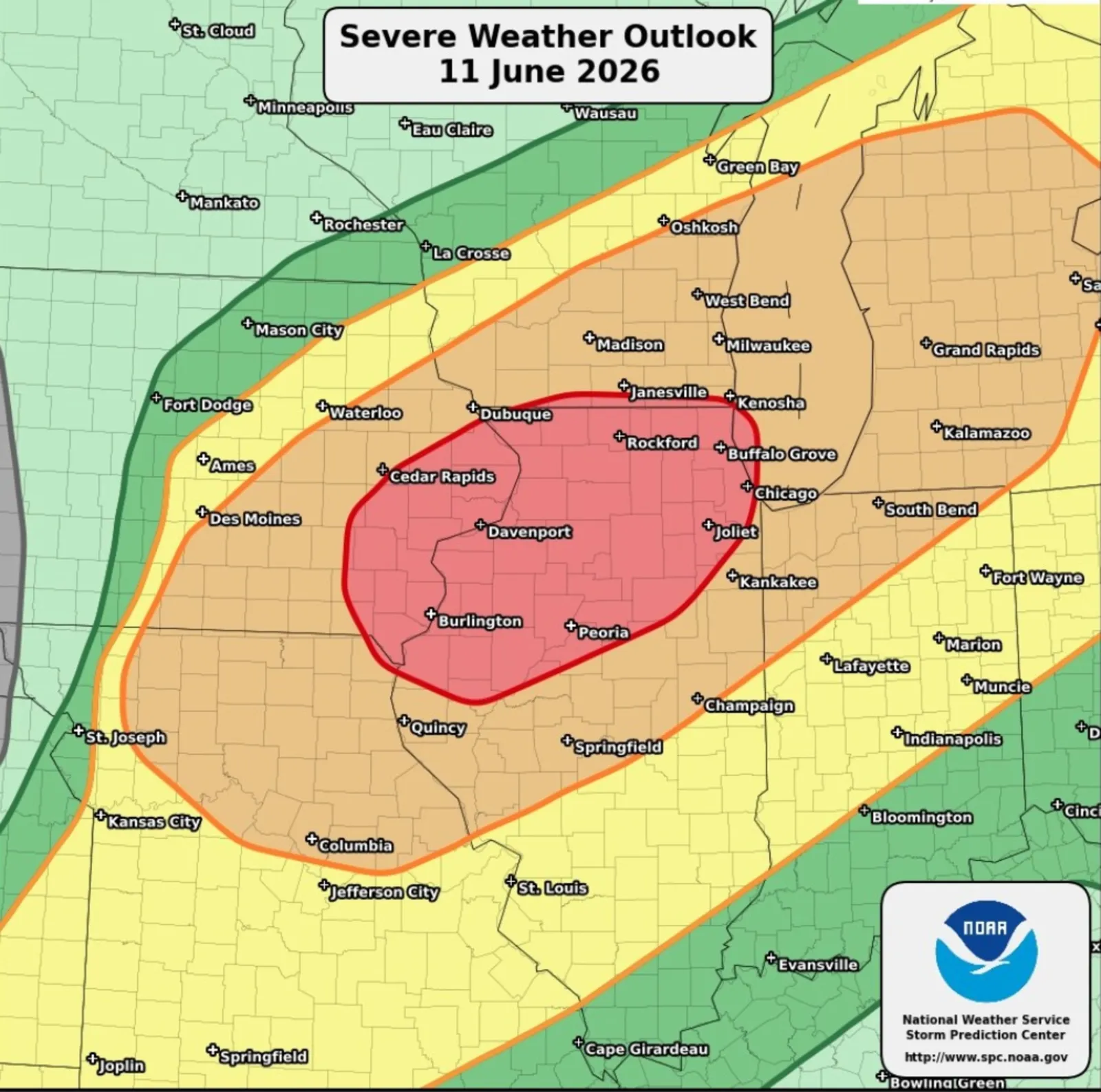
The developing conditions are part of a broader multiday severe weather pattern across the Midwest this week, with repeated storm systems forecast to move across the region. Similarly strong storms struck Illinois and Wisconsin on Wednesday evening. The NWS briefing highlights not just a one-day event, but a prolonged period of instability fueled by heat, humidity and a favorable storm environment. The broader regional outlook reinforces the concern, with northern Illinois included in a zone where widespread severe thunderstorms are expected. The storms could produce damaging winds, hail and tornadoes—some of which may be strong.
"All of the ingredients required for severe thunderstorms will be in place across the Plains and Midwest for a severe weather outbreak [through] Thursday,” AccuWeather Expert Meteorologist Brandon Buckingham told Newsweek.
Read More on Weather
“An ample amount of moisture, a highly unstable atmosphere and support from the upper levels of the atmosphere in the form of back-to-back troughs of low pressure ejecting out of the Rockies will likely result in hundreds of severe weather reports. Wind gusts capable of approaching 100 miles per hour, hail the size of softballs, and dozens of tornado reports across the Plains and Midwest are expected."
The Federal Emergency Management Agency (FEMA) also issued a message about the incoming storms ahead of time, indicating potentially dangerous conditions later Thursday night.
"Severe weather is expected to impact parts of the Upper Midwest and Great Plains today," FEMA posted on X. "Keep an eye on your local forecast and make sure your emergency alerts are turned on. Have more than one way to get warnings so you know when to take action. Always listen to local officials."
Chicago Tornado Watch: What We Know
On Thursday afternoon, a tornado watch went out for Chicago, as well as for the northern half of Illinois, part of southern Wisconsin, northwestern Indiana, southeastern Iowa and northeastern Missouri. Most watches will remain in effect until 9 p.m. Central.
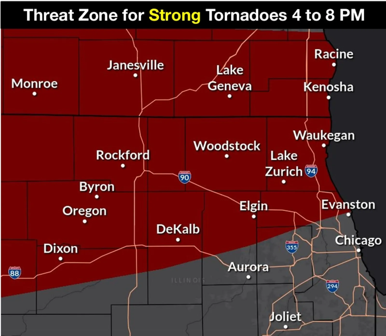
According to the latest NWS Chicago briefing, two distinct rounds of thunderstorms are expected to sweep across the region on Thursday. The first round, forecast between late morning and mid-afternoon, is expected to bring damaging winds and hail, while a second round later in the day could pose a greater threat of tornadoes.
"There is a threat for strong (EF-2+) tornadoes between 4 and 8 PM especially in the dark red shaded area along a stalled warm front," NWS Chicago said in the briefing, including the below map of the greatest risk area.
...
The first wave of severe storms is currently underway, with meteorologists saying storms could pop up between 11 a.m. and 3 p.m. local time on Thursday. The briefing does not indicate that a tornado warning is currently in effect. Instead, it outlines the evolving threat environment, with conditions expected to become favorable for significant severe weather, including tornadoes, damaging winds and large hail, later in the day.
Forecasters said that the second wave, expected from late afternoon into the evening hours, carries the greatest concern for “strong tornadoes,” along with destructive wind gusts.
Animated weather footage from windy.com shows a line of severe storms advancing across Illinois as of 12:30 p.m. Eastern.
The NWS Storm Prediction Center has assigned a Level 4 of 5 severe weather risk to parts of the Chicago area, indicating a significant potential for tornado development relative to typical conditions.
Officials are urging residents to prepare in advance, noting that severe weather may arrive in multiple waves, increasing the chance of impacts across a wide area.
Tornado Watch vs. Tornado Warning
A tornado watch means conditions are favorable for tornadoes to develop in a broad area, so people should stay alert and be prepared to take action, while a tornado warning means a tornado has been spotted or indicated by radar and there is an immediate threat, requiring people in the affected area to take shelter right away. In short, a watch signals that tornadoes are possible, whereas a warning means a tornado is occurring or imminent and action is urgently needed.
In a livestream on Thursday afternoon, an NWS Storm Prediction Center spokesperson stressed that tornadoes are not the only severe weather threat for Thursday night. Whereas dozens, or at times hundreds, of people can be impacted by tornadoes, thousands will feel the impacts of strong, straight-line winds that could reach hurricane-strength speeds.
A high wind warning is in effect for Chicago and surrounding areas.
"Damaging winds will blow down trees and power lines. Widespread power outages are expected. Travel will be difficult, especially for high profile vehicles," the warning said.
How Do Tornadoes Form?
Tornadoes typically develop within powerful thunderstorms known as supercells, which contain a rotating updraft called a mesocyclone. These storms form when warm, moist air near the surface rises into cooler, drier air aloft, creating atmospheric instability.
Wind shear—changes in wind speed and direction with height—allows the storm to begin rotating. As this rotation tightens and intensifies, it can eventually extend downward from the storm cloud, forming a visible funnel that becomes a tornado when it reaches the ground.
In the current setup across the Midwest, the combination of heat, humidity and strong upper-level winds is expected to create an environment favorable for these rotating storms, particularly during the second round of storms later in the day.
...
Tornado Rating Scale: What Is a 'Strong' Tornado?
The strength of a tornado is measured using the Enhanced Fujita (EF) scale, which classifies tornadoes based on the damage they cause.
A “strong” tornado generally refers to those rated EF2 or higher. These storms can cause significant destruction, including tearing roofs off well-built homes, overturning vehicles and snapping large trees.
Recent forecasts for the Chicago area indicate that tornadoes that develop could reach this stronger category, though the exact intensity will depend on how storms evolve.
Officials note that conditions such as storm structure, wind shear and the location of atmospheric boundaries like warm fronts can all influence whether tornadoes remain weak or intensify into strong, long-lived events.
Chicago Tornado Threat: What Happens Next
Forecasters emphasize that while the risk is elevated, the exact location and timing of tornado development remain uncertain, which is typical in severe weather setups like this.
Still, the presence of multiple storm rounds, a favorable severe weather environment and the potential for strong tornadoes have prompted officials to urge vigilance. Residents are advised to monitor updates closely, have multiple ways to receive warnings and be prepared to take action quickly if a tornado warning is issued.
View 0 Comments
Submit Correction
View Editorial & AI Guidelines