
By Amanda Castro
Associate News Editor
0
Share
Newsweek is a Trust Project member
See more of our trusted coverage when you search.Prefer Newsweek on Googleto see more of our trusted coverage when you search.
A fast-moving wildfire dubbed the Canyon Fire has scorched 5,000 acres across Ventura and Los Angeles counties, prompting mandatory evacuations and a local emergency proclamation. The blaze erupted Thursday afternoon near Lake Piru and quickly spread eastward, threatening homes, infrastructure, and power lines. Officials say the fire remains uncontained, with extreme heat and dry conditions fueling its rapid growth.
What to Know:
- The Canyon Fire began at 1:25 p.m. Thursday near Highway 126 and Castaic.
- As of late Thursday, the fire had grown to 4,856 acres with zero containment.
- Mandatory evacuations are in place for zones near Lake Piru and Val Verde.
- Over 2,700 residents and 700 structures are under evacuation orders.
- An additional 14,000 people and 4,700 structures are under evacuation warnings.
- Los Angeles County declared a local emergency to expedite aid and resources.
This live blog is now closed.
Aug 08, 2025 at 04:01 PM EDT
Shocking images of the Gifford Fire

...

...

...
Aug 08, 2025 at 03:51 PM EDT
Wildfire smoke triggers air quality alerts across US, raises health concerns

...
Air quality alerts were issued in 11 states this week as smoke from Canada's record-breaking wildfire season and California's Gifford Fire—now burning nearly 100,000 acres with only 15% containment—spread across the country. The smoke has blanketed major cities from New York to Denver, prompting warnings for vulnerable populations and even disrupting air travel.
While the flames themselves pose immediate danger, new research suggests the smoke may be far deadlier. A recent study examining the January Palisades and Eaton fires in Los Angeles found that while 30 deaths were officially recorded, excess mortality data points to a death toll closer to 440. Researchers attribute the discrepancy to toxic smoke exposure, which can worsen heart and lung conditions and trigger fatal complications far from the fire zone.
Wildfire smoke contains fine particulate matter known as PM2.5—tiny particles capable of entering the bloodstream and causing inflammation, respiratory distress, and cardiovascular strain. These pollutants can linger in the air long after flames are extinguished, disproportionately affecting low-income and marginalized communities with limited access to clean air and healthcare.
Experts say the growing intensity and reach of wildfires demand a more proactive public health response, including community air filtration programs and better emergency planning for hospitals. As climate change fuels more extreme fire behavior, understanding and mitigating the long-term health impacts of smoke exposure is becoming increasingly urgent.
Aug 08, 2025 at 03:40 PM EDT
Evacuation orders issued for Runner Fire in San Diego County
Evacuation orders were issued Friday for zones SDC-2242 and SDC-2243 in San Diego County as the Runner Fire burned through 25 acres near Roadrunner Lane and Moonlit Trail Boulevard in the Boulevard area. The blaze, first reported around 11:30 a.m., prompted a rapid response from fire crews as smoke became visible for miles.
Aug 08, 2025 at 03:27 PM EDT
Where containment statuses stand on active wildfires
The California Department of Forestry and Fire Protection (CAL FIRE) has responded to more than 357,000 emergency incidents this year, including 5,124 wildfires that have burned nearly 280,000 acres across the state. The fires have resulted in 31 fatalities and the destruction of over 16,000 structures.
Among the most active incidents is the Gifford Fire, which ignited on August 1 in San Luis Obispo and Santa Barbara counties and has consumed more than 99,000 acres with just 15% containment. The Orleans Complex, burning since July 9 in Del Norte and Siskiyou counties, has reached 22,080 acres and is 81% contained. Shasta County's Green Fire, which started July 1, is nearly fully contained after burning 19,022 acres.
More recent outbreaks include the Canyon Fire in Los Angeles and Ventura counties, which began August 7 and remains uncontained at 4,856 acres, and the Rosa Fire in Riverside County, which has burned 1,690 acres since August 4 and is 40% contained.
CAL FIRE continues to deploy air assets and ground crews statewide, supported by real-time mapping tools that track evacuation orders, wind conditions, and fire perimeters. Officials urge residents to stay alert as red flag warnings and smoke hazards persist.
Aug 08, 2025 at 03:11 PM EDT
Rose Fire: Evacuation order downgraded as containment progresses
CAL FIRE/Riverside County Fire Department announced Friday morning that evacuation orders for several zones impacted by the Rosa Fire have been downgraded to evacuation warnings, allowing many residents to return home. The fire, which ignited Monday near Highway 74 west of Ribbonwood, has burned approximately 1,690 acres and is now 40% contained.
Evacuation orders remain in effect for zones RVC-2122A, RVC-1983A, and RVC-2121A, covering areas north of Santa Rosa Truck Trail, east of Santa Rosa Road, south of Saint Pierre Road, and west of Palm Canyon Drive. Warnings are now in place for adjacent zones including RVC-2122B, RVC-2051, RVC-2052, RVC-1984, and RVC-1983B.
Highway 74 remains closed at Palm Canyon Drive and the Santa Rosa Pit Stop. CAL FIRE cautions returning residents that visible smoke or flames may persist due to unburned fuel within the fire perimeter. Anyone observing fire outside containment lines or feeling unsafe is urged to call 911 immediately.
Aug 08, 2025 at 02:57 PM EDT
Rosa Fire burns 10 acres and is ‘spreading rapidly’: CalFire
Firefighters are battling a fast-moving vegetation fire reported at 12:26 p.m. Monday in the 63000 block of Highway 74, west of Ribbonwood, according to CAL FIRE/Riverside County Fire Department. The blaze, dubbed the Rosa Fire, has scorched approximately 10 acres and is spreading rapidly. Additional air and ground resources have been requested to contain the flames. Updates are being coordinated with @RivCoNow.
Aug 08, 2025 at 02:44 PM EDT
Evacuation and closures explained
As of Friday morning, crews had managed to establish 25% containment, but officials warned that shifting winds and rugged terrain could hamper progress. More than 700 firefighters from local and state agencies are battling the blaze, supported by helicopters dropping water and fire retardant.
Evacuation Orders
Evacuation mandates have been issued for:
- Ventura County: Entire Lake Piru Recreation Area; areas east of Piru Canyon Road extending to the L.A. County line; and zones east of Piru's Center Street along Highway 126.
- Los Angeles County: Regions west of Castaic, including Hasley Canyon and Romero Canyon, bordered on the south by Highway 126 and on the north by Romero Canyon Road.
Evacuation Warnings
Residents in these corridors have received pre-evacuation alerts:
- North of Lake Piru.
- West of Interstate 5 and north of Route 126, encompassing Hasley Canyon, Val Verde and parts of Castaic.
Road and Facility Closures
Authorities have closed several key routes and facilities:
- Piru Canyon Road at Main Street.
- Lake Piru Recreation Area (under full evacuation).
- Lake Hughes Road between two miles north of Ridge Route Road and Pine Canyon Road.
- Castaic Library (located within an evacuation warning zone).
Emergency Shelters
Shelter and animal evacuation centers are available at:
- People: East Gymnasium, College of the Canyons, 26455 Rockwell Canyon Road (parking Lots 5–7).
- Large animals: Pierce College Equestrian Center, 6201 Winnetka Avenue, Woodland Hills.
- Small animals: Castaic Animal Care Center, 31044 Charlie Canyon Road; Agoura Animal Shelter, 29525 Agoura Road.
Residents are urged to follow evacuation instructions, keep clear of fire lines, and monitor local alerts for updates.
Aug 08, 2025 at 02:32 PM EDT
Wildfire activity intensifies nationwide amid heightened preparedness
The National Interagency Fire Center (NIFC) reports a surge in wildfire activity across the U.S., with 76 large fires currently burning and over 16,600 personnel deployed nationwide. As of early August, more than 38,900 wildfires have scorched nearly 2.9 million acres—above the 10-year average for fire incidents, though slightly below average in acreage burned.
The national preparedness level remains at 4 out of 5, signaling significant strain on firefighting resources. Weather conditions continue to challenge containment efforts, with dry air, gusty winds, and lightning storms fueling fire spread across the West, particularly in California, Nevada, Utah, and Arizona.
Officials urge residents in fire-prone areas to clear vegetation, maintain visible hydrants, and prepare evacuation plans. Community readiness and early action remain critical as the fire season intensifies. For safety tips and updates, visit NIFC's National Fire News.
Aug 08, 2025 at 02:21 PM EDT
Update from LA County Fire Department: Canyon Fire cause still ‘under investigation’
The LA County Fire Department has shared an update to its X, saying that the cause for the Canyon Fire is still "under investigation."
Aug 08, 2025 at 02:11 PM EDT
Canyon Fire prompts evacuation orders across Ventura and LA counties
Mandatory evacuation orders have been issued for multiple zones in Ventura and Los Angeles counties as the Canyon Fire continues to burn with zero containment. Officials warn of an immediate threat to life, urging residents in affected areas to leave immediately.
Evacuation orders are in effect for zones including CAS-HASLEY, CAS-ROMERO, CAS-OAKCANYON, CAS-VALVERDE B and D, and CAS-GOLDENSTATE C and D in Los Angeles County. In Ventura County, PIRU-01, PIRU-14, and LAKP-04 through LAKP-06 are under evacuation orders.
Evacuation warnings—indicating a potential threat—have been issued for CAS-GOLDENSTATE B, CAS-GREENHILL, CAS-SLOAN, CAS-HILLCREST, CAS-CAMBRIDGE, CAS-VALVERDE A and C, and CAS-INDUSTRY in Los Angeles County. Ventura zones LAKP-01 and LAKP-02 are also under warning.
The fire has scorched nearly 5,000 acres since Thursday, fueled by extreme heat and dry conditions. Officials urge residents to monitor local alerts and leave early if they need extra time or have pets and livestock.
Aug 08, 2025 at 12:59 PM EDT
Study links climate change to earlier wildfire seasons in California
A new study published in Science Advances finds that human-driven climate change is accelerating the start of wildfire season across California. Researchers analyzed fire data from 1992 to 2020 across 13 ecoregions. They found that in 11 of them, fire season onset has shifted earlier by 6 to 46 days due to rising temperatures and declining fuel moisture.
The study stresses how warming has intensified fire-conducive conditions, especially in Northern California, where the trend toward earlier fire activity is strongest. Scientists say this shift increases the likelihood of longer, more destructive fire seasons.
As global temperatures continue to rise, the researchers warn that early fire season onset will become more common, posing greater risks to communities, ecosystems, and emergency response systems.
Aug 08, 2025 at 12:52 PM EDT
WATCH: Wildfires in Southern California prompt evacuations
Aug 08, 2025 at 12:41 PM EDT
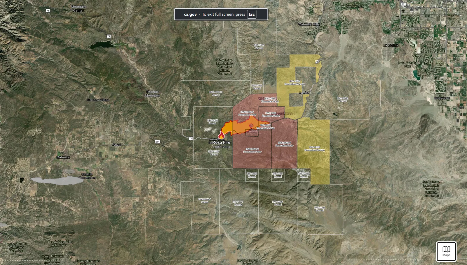
Rosa Fire grows to 1,690 acres, containment reaches 40 percent
The Rosa Fire continued to burn through remote terrain in Riverside County on Friday, reaching 1,690 acres with 40 percent containment. The blaze began Monday near Highway 74 in the San Bernardino National Forest, between Anza and Pinyon Pines.
Despite threatening nearly 500 structures, no homes have been damaged or destroyed, and no injuries have been reported. Firefighters are working in steep, rugged terrain with support from air crews to strengthen containment lines.
Evacuation orders and warnings remain in effect for several communities, including Pinyon Pines and Alpine Village. Highway 74 is closed between the 101 Freeway and State Route 33, with no timeline yet for reopening.
Officials say dry conditions and shifting winds could complicate efforts in the coming days.
...
Aug 08, 2025 at 12:29 PM EDT
Gifford Fire nears 100,000 acres, forces more widespread evacuations
California's largest wildfire of the year surged to 99,200 acres Friday, tearing through Santa Barbara and San Luis Obispo counties with only 15 percent containment. The Gifford Fire ignited one week ago near Highway 166 northeast of Santa Maria and has since grown rapidly, fueled by extreme heat and dry conditions.
Evacuation orders and warnings remain in effect across multiple zones, including areas near Lopez Lake, Huasna Valley, and Cottonwood Canyon. More than 870 structures are threatened, and officials have reported several injuries, including a firefighter treated for dehydration.
Highway 166 is closed between the 101 Freeway and State Route 33, cutting off access to key communities. Fire crews are battling the blaze with over 2,200 personnel, using helicopters, air tankers, and ground teams to slow its advance through steep, inaccessible terrain.
Aug 08, 2025 at 12:15 PM EDT
Canyon Fire destroys and damages homes
The Canyon Fire has destroyed seven homes and damaged ten more in Hasley Canyon, Ventura County. The blaze erupted Thursday afternoon and quickly spread east into Los Angeles County, fueled by scorching temperatures, dry conditions, and rugged terrain.
Aug 08, 2025 at 12:12 PM EDT
WATCH: Scenes of the Canyon Fire
Aug 08, 2025 at 12:01 PM EDT
Gifford fire becomes California’s largest fire of 2025

...
A massive wildfire tearing through Los Padres National Forest has become California's largest of the year, scorching nearly 100,000 acres across San Luis Obispo and Santa Barbara counties. The Gifford Fire, which began as four smaller fires along Highway 166, was 15% contained as of Friday morning.
Evacuation orders and warnings remain in effect, with hundreds of homes under threat. At least four people have been injured, and Highway 166 is closed in both directions east of Santa Maria. More than 3,400 personnel are battling the fire, including crews from San Francisco and other regions.
Extreme heat and dry conditions are expected to worsen through the weekend, heightening wildfire risk across inland California. August and September are historically the state's most dangerous months for fire activity.
Aug 08, 2025 at 11:50 AM EDT
Canyon fire slows as weather conditions improve
Firefighters made progress overnight on the Canyon Fire burning near Castaic, California, thanks to cooler temperatures and lighter winds. Crews worked to establish containment lines around the blaze, which has scorched nearly 5,000 acres in steep terrain along the Ventura–Los Angeles county line.
The fire, which ignited August 7 near Lake Piru, remains uncontained but has not damaged any homes. Evacuation orders and warnings are in effect for several nearby communities, including Val Verde and parts of Santa Clarita. Air tankers and helicopters continue to support ground crews as officials brace for more hot, dry conditions through the weekend.
Aug 08, 2025 at 11:38 AM EDT
Colorado wildfires force evacuations as Lee and Elk fires grow
Colorado is battling at least ten wildfires this August, with over 127,000 acres burned statewide. The Lee Fire near Meeker has exploded to nearly 60,000 acres and remains 0% contained, prompting pre-evacuation orders for the town and evacuations nearby. The nearby Elk Fire has burned 15,000 acres and is also uncontained.
Other active fires include the Turner Gulch Fire (26,000 acres, 49% contained) and the South Rim Fire in Black Canyon of the Gunnison, which has damaged park buildings. Smaller fires in Grand and Moffat counties are growing, with Highway 40 closed due to the Twelve Fire.
Dry conditions and high winds are fueling rapid spread. All of Colorado's largest wildfires have occurred since 2001, with the three biggest—Cameron Peak, East Troublesome, and Pine Gulch—burning in 2020. Officials warn the threat remains high through mid-August.
Aug 08, 2025 at 11:19 AM EDT
With fires raging coast to coast, Canada mobilizes national response
Wildfires are tearing across Canada from Vancouver Island to Newfoundland, prompting mass evacuations and a nationwide emergency response. On Thursday, federal officials deployed the Canadian Armed Forces and Coast Guard to assist Newfoundland and Labrador, where three out-of-control fires forced 900 residents to flee their homes.
The situation is dire. Canada's national fire threat level has remained at its highest rating—Level 5—since May. Over 7.1 million hectares of forest have burned so far this season, making 2025 the second-worst year on record after 2023. More than 725 fires are currently active, with many burning out of control.
In British Columbia, the Wesley Ridge fire near Nanaimo has triggered evacuation orders for hundreds of homes. Though some residents were allowed to return briefly, heavy smoke continues to blanket the area. Meanwhile, Manitoba remains under its second state of emergency this year, with 14,000 people displaced and officials calling it the worst fire season in three decades.
Smoke from the blazes has degraded air quality across Ontario, Quebec, and parts of the northeastern United States. Toronto recently ranked among the cities with the worst air pollution globally, with Environment Canada issuing repeated health advisories.
To curb further fire outbreaks, provinces have enacted bans on hiking, fishing, and the use of off-road vehicles in forested areas. Nova Scotia Premier Tim Houston expressed deep concern, saying, "I'm losing sleep about what's happening."
Emergency Management Minister Eleanor Olszewski confirmed that federal resources—including helicopters, water bombers, and humanitarian support—are being deployed to assist overwhelmed provinces. With domestic firefighting capacity stretched thin, Canada has also requested international aid.
As climate change fuels longer, more intense fire seasons, officials warn that the crisis may persist for weeks. The country's response is now a full-scale mobilization—an effort to protect lives, infrastructure, and the environment amid unprecedented conditions.
Aug 08, 2025 at 10:49 AM EDT
Symptoms from wildfire smoke: What to watch out for

...
Wildfire smoke is increasingly recognized as a serious health hazard, not just an environmental issue. The U.S. Environmental Protection Agency (EPA) reports that smoke from wildfires contains a mix of harmful pollutants, including fine particulate matter (PM2.5). These microscopic particles are especially dangerous because they can bypass the body's natural defenses, reaching deep into the lungs and even entering the bloodstream.
Short-term exposure to wildfire smoke can trigger symptoms like coughing, throat irritation, shortness of breath, and eye discomfort. For individuals with asthma or other respiratory conditions, these effects can be more severe. Long-term or repeated exposure may lead to more serious outcomes, including bronchitis, reduced lung function, heart attacks, strokes, and even premature death.
Certain populations face heightened risks from wildfire smoke. Children are particularly vulnerable due to their developing lungs and higher breathing rates. Older adults often have pre-existing health conditions that make them more susceptible to smoke-related complications. Pregnant people, outdoor workers, and individuals with cardiovascular or respiratory diseases are also at increased risk.
Socioeconomic factors play a role as well. Communities with limited access to healthcare, clean air resources, or protective infrastructure may experience more severe health impacts. The EPA notes that environmental justice concerns are central to understanding who bears the brunt of wildfire smoke exposure.
To reduce risk, the EPA recommends monitoring local air quality, staying indoors during smoke events, using high-efficiency air filters, and creating clean air spaces at home. These steps are especially important for those in high-risk groups. As wildfires become more frequent and intense, understanding and mitigating the health effects of smoke is critical for public safety.
Aug 08, 2025 at 10:36 AM EDT
Everything to know about California wildfire evacuations
When wildfires threaten, quick and informed action can save lives. CAL FIRE's "Go! Evacuation Guide" offers essential steps to help Californians prepare for and respond to evacuation orders during wildfire emergencies.
Key Preparation Tips:
- Before You Go: Pack an emergency kit, update your Wildfire Action Plan, and know your community's evacuation routes.
- Inside Your Home: Close windows and doors (leave them unlocked), remove flammable curtains, and shut off gas and air conditioning.
- Outside Your Home: Bring in flammable items, shut off propane, and attach garden hoses for firefighter use.
- Vehicle Readiness: Park facing outward with your emergency kit inside and all doors closed.
Animal Safety: Keep pets nearby and ready to evacuate. For livestock, plan transport and shelter in advance.
Evacuation Protocol: If evacuation becomes necessary, follow your checklist, wear protective clothing, and leave immediately. Don't wait for official orders if you feel unsafe.
Aug 08, 2025 at 10:22 AM EDT
What to know about the California wildfires today
California's wildfire season is surging, with the state's fire agency reporting 5,124 wildfires and nearly 280,000 acres burned in 2025. CAL FIRE has responded to more than 357,000 emergencies this year, with 31 fatalities and over 16,000 structures lost.
Currently Active Fires:
Several major wildfires are burning across the state:
- Gifford Fire (San Luis Obispo, Santa Barbara): 99,232 acres, 15% contained
- Orleans Complex (Del Norte, Siskiyou): 22,069 acres, 81% contained
- Green Fire (Shasta): 19,022 acres, 99% contained
- Canyon Fire (Los Angeles, Ventura): 4,856 acres, 0% contained
- Rosa Fire (Riverside): 1,690 acres, 40% contained
CAL FIRE warns that extreme heat, dry fuels, and rugged terrain are driving dangerous fire conditions statewide. Southern California faces an elevated risk through the weekend as a heatwave intensifies. August and September are historically peak wildfire months.
Residents are urged to monitor evacuation alerts and use CAL FIRE's interactive maps for real-time updates on fire perimeters, wind conditions, and air support activity.
Aug 08, 2025 at 10:09 AM EDT
Canyon Fire map, update as California blaze explodes in size near Lake Piru

...
The Canyon Fire burning north of Los Angeles has now grown to nearly 5,000 acres in size, prompting several areas to be put under evacuation orders.
The Canyon Fire's rapid growth and spread into both Los Angeles and Ventura counties have forced thousands to evacuate. The fire had still not been contained in the early hours of Friday.
The blaze is burning around the border between Los Angeles County and Ventura County, near Lake Piru.
The wildfire began around 1:30 p.m. on Thursday near Lake Piru, according to Cal Fire. It was initially reported to be about 30 acres, but quickly grew to 1,500 acres. As of the early hours of Friday morning, it had spread to 4,800 acres, according to the Ventura County Fire Department.
The cause of the fire is still under investigation, and it was 0 percent contained in the early hours of Friday morning.
Aug 08, 2025 at 09:54 AM EDT
Canyon fire forces evacuations as Southern California blaze spreads rapidly

...
A fast-moving wildfire known as the Canyon Fire has erupted near the Ventura–Los Angeles County line, scorching nearly 5,000 acres within hours and prompting widespread evacuations. The blaze ignited Thursday afternoon near Lake Piru and quickly expanded eastward, fueled by triple-digit temperatures, dry vegetation, and light winds.
Authorities have issued mandatory evacuation orders for multiple zones, including Val Verde, Hasley Canyon, and areas surrounding Lake Piru. Over 2,700 residents and 700 structures are under direct evacuation orders, while warnings affect an additional 14,000 people and 4,700 buildings.
Los Angeles County declared a local emergency to accelerate access to firefighting resources. Supervisor Kathryn Barger emphasized the urgency, stating the proclamation would help protect lives and infrastructure amid worsening conditions.
Firefighters from both Ventura and Los Angeles counties are battling the blaze with air tankers and ground crews, but containment remains at zero. The cause of the fire is still under investigation.
View 0 Comments
Submit Correction
View Editorial & AI Guidelines